Difference between revisions of "2020-09-20 52 4"
From Geohashing
(Created page with "{{subst:Expedition}}") |
m (Location) |
||
| (8 intermediate revisions by one other user not shown) | |||
| Line 1: | Line 1: | ||
| − | + | {{meetup graticule | lat=52 | lon=4 | date=2020-09-20}} | |
| − | + | __NOTOC__ | |
| − | |||
| − | |||
| − | |||
| − | |||
| − | |||
| − | |||
| − | |||
| − | |||
| − | |||
| − | |||
== Location == | == Location == | ||
| − | + | Elswout Estate in Overveen. | |
== Participants == | == Participants == | ||
| − | + | [[User:Palmpje | Palmpje]] travelled to the hash. | |
| − | |||
== Plans == | == Plans == | ||
| − | + | The plan was simple, drive to Elwout, park the car and walk to the hash. | |
== Expedition == | == Expedition == | ||
| − | + | Plan went pretty well. Palmpje was lucky because he could still park for free. That would no longer be possible in the near future. Covid meant there were a lot of people taking walks. Because he was early Palmpje first went to find a nearby geocache. After logging that one he went to the hash location. Just before reaching the hash he found an old ice cellar. And after that the hash. It was located between some trees, so rather hard to pinpoint the actual spot. | |
| − | |||
| − | |||
| − | |||
== Photos == | == Photos == | ||
| − | |||
| − | |||
| − | |||
<gallery perrow="5"> | <gallery perrow="5"> | ||
| + | Image:20200920-GPS.jpg | Took 4 minutes to locate the almost exact spot! | ||
| + | Image:20200920-IceCellar.jpg | Ice cellar | ||
| + | Image:20200920 TheSpot.jpg | The spot | ||
</gallery> | </gallery> | ||
== Achievements == | == Achievements == | ||
{{#vardefine:ribbonwidth|800px}} | {{#vardefine:ribbonwidth|800px}} | ||
| − | + | {{land geohash | latitude = 52 | longitude = 4 | date = 2020-09-20 | name = [[User:Palmpje|Palmpje]]}} | |
| − | |||
| − | |||
| − | |||
| − | |||
| − | |||
| − | |||
| − | |||
| − | |||
| − | |||
| − | [[ | ||
| − | |||
| − | |||
| − | |||
| − | |||
[[Category:Expeditions]] | [[Category:Expeditions]] | ||
| − | |||
[[Category:Expeditions with photos]] | [[Category:Expeditions with photos]] | ||
| − | |||
| − | |||
| − | |||
| − | |||
| − | |||
[[Category:Coordinates reached]] | [[Category:Coordinates reached]] | ||
| − | + | {{location|NL|NH}} | |
| − | |||
| − | |||
| − | |||
| − | |||
| − | |||
| − | |||
| − | |||
| − | |||
| − | |||
| − | |||
| − | |||
| − | |||
| − | |||
| − | |||
| − | |||
| − | |||
| − | |||
Latest revision as of 14:42, 26 December 2020
| Sun 20 Sep 2020 in 52,4: 52.3747719, 4.5975737 geohashing.info google osm bing/os kml crox |
Location
Elswout Estate in Overveen.
Participants
Palmpje travelled to the hash.
Plans
The plan was simple, drive to Elwout, park the car and walk to the hash.
Expedition
Plan went pretty well. Palmpje was lucky because he could still park for free. That would no longer be possible in the near future. Covid meant there were a lot of people taking walks. Because he was early Palmpje first went to find a nearby geocache. After logging that one he went to the hash location. Just before reaching the hash he found an old ice cellar. And after that the hash. It was located between some trees, so rather hard to pinpoint the actual spot.
Photos
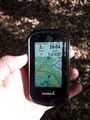
Took 4 minutes to locate the almost exact spot!
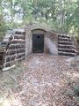
Ice cellar
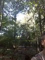
The spot


Achievements
Palmpje earned the Land geohash achievement
|