Difference between revisions of "2020-10-04 50 19"
(creating a stub) |
m (Location correction) |
||
| (5 intermediate revisions by one other user not shown) | |||
| Line 1: | Line 1: | ||
| − | + | {{meetup graticule | |
| − | |||
| − | |||
| − | |||
| − | |||
| − | |||
| − | |||
| − | |||
| − | |||
| lat={{#explode:{{SUBPAGENAME}}| |1}} | | lat={{#explode:{{SUBPAGENAME}}| |1}} | ||
| lon={{#explode:{{SUBPAGENAME}}| |2}} | | lon={{#explode:{{SUBPAGENAME}}| |2}} | ||
| date={{#explode:{{SUBPAGENAME}}| |0}} | | date={{#explode:{{SUBPAGENAME}}| |0}} | ||
| − | }} | + | }} |
__NOTOC__ | __NOTOC__ | ||
== Location == | == Location == | ||
| − | + | ||
| + | Forest near Trzebyczka village, Silesian voivodeship, Poland. | ||
== Participants == | == Participants == | ||
| − | |||
| − | |||
| − | + | [[User:Zyxist|Zyxist]] ([[User talk:Zyxist|talk]]) | |
| − | |||
== Expedition == | == Expedition == | ||
| − | + | The hashpoint was quite far away from Kraków, so I decided to get there by car. I needed to reach out Trzebyczka village - there is only one road going there which ends with a balloon loop for buses. I parked several hundred meters further, at the entrace to the forest, changed my shoes and started walking. The weather was nice, but it was very wet after week-long rains. I followed a muddy path for about 1 km, until I reached some meadows. There, I turned south deeper into the forest. When I was less than 300 meters from the hash point, things got a bit harder - it turned out that the area is covered with a lot of shrubs and other plants and I had some trouble navigating through it. At one moment I was a bit afraid that it might be impossible to get to the destination, but finally I managed to locate the point and take the photo for the proof. I didn't spend too much time there, because the midges started attacking me. I got back to the car, and drove back to Kraków. | |
== Tracklog == | == Tracklog == | ||
| − | + | {{tracklog | 2020 10 04 50 19 expedition.gpx}} | |
== Photos == | == Photos == | ||
| − | |||
| − | |||
| − | |||
<gallery perrow="5"> | <gallery perrow="5"> | ||
| + | File:2020 10 04 50 19 01 parking.jpg | Parking at the forest entrace | ||
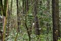
| + | File:2020 10 04 50 19 02 forest.jpg | Beginning of the walk | ||
| + | File:2020 10 04 50 19 03 proof.jpg | Proof (within GPS uncertainity) | ||
| + | File:2020 10 04 50 19 04 geohash.jpg | I marked the geohash with a small hole :) | ||
| + | File:2020 10 04 50 19 05 civilization.jpg | Detected traces of civilization on a bush nearby. | ||
</gallery> | </gallery> | ||
| − | |||
{{#vardefine:ribbonwidth|800px}} | {{#vardefine:ribbonwidth|800px}} | ||
| − | |||
| − | |||
| − | |||
| − | |||
| − | |||
| − | |||
| − | |||
| − | |||
| − | |||
| − | |||
| − | |||
| − | |||
| − | |||
| − | |||
| − | |||
[[Category:Expeditions]] | [[Category:Expeditions]] | ||
| − | + | [[Category:Coordinates reached]] | |
[[Category:Expeditions with photos]] | [[Category:Expeditions with photos]] | ||
| − | + | {{location|PL|S|ZA}} | |
| − | |||
| − | |||
| − | |||
| − | |||
| − | |||
| − | |||
| − | |||
| − | |||
| − | |||
| − | |||
| − | |||
| − | |||
| − | |||
| − | |||
| − | |||
| − | |||
| − | |||
| − | |||
| − | |||
| − | |||
| − | |||
| − | |||
| − | |||
Latest revision as of 20:36, 5 October 2020
| Sun 4 Oct 2020 in 50,19: 50.3921119, 19.3739426 geohashing.info google osm bing/os kml crox |
Location
Forest near Trzebyczka village, Silesian voivodeship, Poland.
Participants
Expedition
The hashpoint was quite far away from Kraków, so I decided to get there by car. I needed to reach out Trzebyczka village - there is only one road going there which ends with a balloon loop for buses. I parked several hundred meters further, at the entrace to the forest, changed my shoes and started walking. The weather was nice, but it was very wet after week-long rains. I followed a muddy path for about 1 km, until I reached some meadows. There, I turned south deeper into the forest. When I was less than 300 meters from the hash point, things got a bit harder - it turned out that the area is covered with a lot of shrubs and other plants and I had some trouble navigating through it. At one moment I was a bit afraid that it might be impossible to get to the destination, but finally I managed to locate the point and take the photo for the proof. I didn't spend too much time there, because the midges started attacking me. I got back to the car, and drove back to Kraków.
Tracklog
Photos
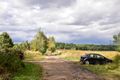
Parking at the forest entrace
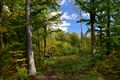
Beginning of the walk
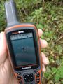
Proof (within GPS uncertainity)
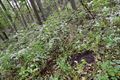
I marked the geohash with a small hole :)
Detected traces of civilization on a bush nearby.


