Difference between revisions of "2020-10-14 47 -122"
([live picture]Spud [https://openstreetmap.org/?lat=47.70536560&lon=-122.21291280&zoom=16&layers=B000FTF @47.7054,-122.2129]) |
(Summary, success, neither Fippe nor I are "last man standing") |
||
| Line 18: | Line 18: | ||
== Expedition == | == Expedition == | ||
| − | < | + | $2.70 for the lunchtime toll - no COVID discount here. Found the neighborhood and street easily. Had a glitch while uploading the third picture, phone seems to have lost connection (couldn't browse the website either) - but it came back later. I'll upload the missing picture shortly. |
| + | |||
| + | Satellite connection was clean; almost parked on the spot. I'd love to park with a reading of <0.3 meters sometime :) After geohasher shot, I chalked for another photo - the missing element. | ||
| + | |||
| + | Following that I headed down the road. [http://kirklandhistory.org/1905-lwbl-ckc/1905-lwbl-firloch/ History (kirklandhistory.org)] time! This neighborhood was called '''Firloch''' due to a mill by the lake. A railroad spur ran to it at one point, and the rest of the railroad is now an urban trail. No mill or spur anymore, but I wanted to see if I could see the lake. Not much chance. Satellite shows a small patch of water and choked vegetation all around, and that matches the boots on the ground. I did find one path leading part-way in, but it seemed to dead end in a mashed down area with some litter - perhaps someone's recent home. If I'm by the area in winter I'll take a comparison photo - bet we can see the lake then. | ||
| + | |||
| + | Geohash and history satisfied, I headed off to join my friends in a lunchtime walk/conference call. Juanita has a nice boardwalk that runs out into the lake; adding in the neighborhood north of that makes for about 30 minutes of walk time. Finally, 1:30 - time for Spud! and a drive home around the north end of the lake. A few miles further but $4.70 cheaper - that's 2 gallons of gas and 80-100 miles for my Prius. | ||
== Tracklog == | == Tracklog == | ||
| Line 41: | Line 47: | ||
{{#vardefine:ribbonwidth|800px}} | {{#vardefine:ribbonwidth|800px}} | ||
<!-- Add any achievement ribbons you earned below, or remove this section --> | <!-- Add any achievement ribbons you earned below, or remove this section --> | ||
| − | |||
| − | |||
| − | |||
| − | |||
| − | |||
| − | |||
| − | |||
| − | |||
| − | |||
| − | |||
| − | |||
| − | |||
| − | |||
[[Category:Expeditions]] | [[Category:Expeditions]] | ||
[[Category:Expeditions with photos]] | [[Category:Expeditions with photos]] | ||
[[Category:Coordinates reached]] | [[Category:Coordinates reached]] | ||
| − | |||
| − | |||
| − | |||
| − | |||
| − | |||
| − | |||
| − | |||
| − | |||
| − | |||
| − | |||
| − | |||
{{location|US|WA|KN}} | {{location|US|WA|KN}} | ||
Latest revision as of 01:42, 15 October 2020
| Wed 14 Oct 2020 in Seattle: 47.7059777, -122.1715134 geohashing.info google osm bing/os kml crox |
Location
A residential street in the Firloch neighborhood, near Totem Lake.
Participants
Plans
Lunchtime visit, toll bridge at least one way.
Expedition
$2.70 for the lunchtime toll - no COVID discount here. Found the neighborhood and street easily. Had a glitch while uploading the third picture, phone seems to have lost connection (couldn't browse the website either) - but it came back later. I'll upload the missing picture shortly.
Satellite connection was clean; almost parked on the spot. I'd love to park with a reading of <0.3 meters sometime :) After geohasher shot, I chalked for another photo - the missing element.
Following that I headed down the road. History (kirklandhistory.org) time! This neighborhood was called Firloch due to a mill by the lake. A railroad spur ran to it at one point, and the rest of the railroad is now an urban trail. No mill or spur anymore, but I wanted to see if I could see the lake. Not much chance. Satellite shows a small patch of water and choked vegetation all around, and that matches the boots on the ground. I did find one path leading part-way in, but it seemed to dead end in a mashed down area with some litter - perhaps someone's recent home. If I'm by the area in winter I'll take a comparison photo - bet we can see the lake then.
Geohash and history satisfied, I headed off to join my friends in a lunchtime walk/conference call. Juanita has a nice boardwalk that runs out into the lake; adding in the neighborhood north of that makes for about 30 minutes of walk time. Finally, 1:30 - time for Spud! and a drive home around the north end of the lake. A few miles further but $4.70 cheaper - that's 2 gallons of gas and 80-100 miles for my Prius.
Tracklog
Photos
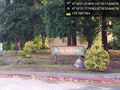
Totem Firs @47.7060,-122.1732
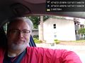
Geohasher @47.7060,-122.1715
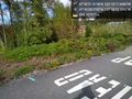
Lake @47.7098,-122.1756
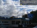
Spud @47.7054,-122.2129


