Difference between revisions of "2020-10-22 64 28"
(Created page with "{{subst:Expedition}}") |
m (Location) |
||
| (4 intermediate revisions by one other user not shown) | |||
| Line 1: | Line 1: | ||
| − | + | {{meetup graticule | |
| − | |||
| − | |||
| − | |||
| − | |||
| − | |||
| − | |||
| − | |||
| − | |||
| lat={{#explode:{{SUBPAGENAME}}| |1}} | | lat={{#explode:{{SUBPAGENAME}}| |1}} | ||
| lon={{#explode:{{SUBPAGENAME}}| |2}} | | lon={{#explode:{{SUBPAGENAME}}| |2}} | ||
| date={{#explode:{{SUBPAGENAME}}| |0}} | | date={{#explode:{{SUBPAGENAME}}| |0}} | ||
| − | }} | + | }} |
__NOTOC__ | __NOTOC__ | ||
== Location == | == Location == | ||
| − | + | In a forest about 270 metres off highway 5 on Säkkilänkangas, Ristijärvi. | |
| + | |||
| + | The point on a topographic map: [https://asiointi.maanmittauslaitos.fi/karttapaikka/?lang=en&share=customMarker&n=7157599.9&e=562448.9&title=Geohash+2020-10-22+64+28&desc=&zoom=10] | ||
== Participants == | == Participants == | ||
| − | + | * [[User:Kripakko|Kripakko]] | |
| − | |||
| − | |||
| − | |||
| − | |||
== Expedition == | == Expedition == | ||
| − | + | I was driving towards the north today with my girlfriend, and this hashpoint happened to be reasonably close to a road along which we would drive anyway, so I wanted to have a go at it. There had been a considerable amount of snowfall during the last week but nothing too severe. I had planned to leave the car at the end of the small forest road and approach from north-northeast, but it was too snowy to get on. Therefore, I opted to leave the car at a bus stop at the nearby intersection with Kirnukoskentie and walk from there. My girlfriend stayed in the car and could move it if necessary. | |
| − | + | I walked about 420 metres back along the road and then went into the woods towards the hashpoint. The first 180 metres or so consisted of pine saplings that were maybe five to seven years old. The depth of the snow was about ten centimetres and maybe more in some places. There were precarious rocks, holes and large twigs under the snow that I had to mind and walk carefully. It got slightly better when I entered the taller forest, but there was of course still a lot of snow, and since the temperature was +2 °C, everything was wet and I got wet up to my waist. I finally reached the hashpoint, took a few quick photographs and left along the same route. I went back to the car as quickly as I could, and we set off again almost immediately. We had several hours' worth of driving ahead of us and not many hours of daylight left. | |
| − | |||
== Photos == | == Photos == | ||
| − | < | + | <gallery perrow="4"> |
| − | Image:2020- | + | Image:2020-10-22_64_28_01-car.jpg | The car parked at the bus stop. |
| − | -- | + | Image:2020-10-22_64_28_02-road.jpg | Looking towards the hashpoint... it is in that tall forest, about 280 metres away. |
| − | + | Image:2020-10-22_64_28_03-track.jpg | My track in the snow about halfway to the hashpoint. | |
| + | Image:2020-10-22_64_28_04-hashpoint.jpg | The hashpoint was approximately at that spruce tree. | ||
| + | Image:2020-10-22_64_28_05-gpsr1.jpg | Hashpoint reached. | ||
| + | Image:2020-10-22_64_28_06-gpsr2.jpg | Proof of date and time. | ||
| + | Image:2020-10-22_64_28_07-selfie.jpg | Selfie at the hashpoint. | ||
</gallery> | </gallery> | ||
== Achievements == | == Achievements == | ||
{{#vardefine:ribbonwidth|800px}} | {{#vardefine:ribbonwidth|800px}} | ||
| − | + | {{land geohash | latitude = 64 | longitude = 28 | date = 2020-10-22 | name = Kripakko }} | |
| − | |||
| − | |||
| − | |||
| − | |||
| − | |||
| − | |||
| − | |||
| − | |||
| − | |||
| − | |||
| − | |||
| − | |||
| − | |||
| − | |||
[[Category:Expeditions]] | [[Category:Expeditions]] | ||
| − | |||
[[Category:Expeditions with photos]] | [[Category:Expeditions with photos]] | ||
| − | |||
| − | |||
| − | |||
| − | |||
| − | |||
[[Category:Coordinates reached]] | [[Category:Coordinates reached]] | ||
| − | + | {{location|FI|05}} | |
| − | |||
| − | |||
| − | |||
| − | |||
| − | |||
| − | |||
| − | |||
| − | |||
| − | |||
| − | |||
| − | |||
| − | |||
| − | |||
| − | |||
| − | |||
| − | |||
| − | |||
Latest revision as of 17:42, 23 October 2020
| Thu 22 Oct 2020 in 64,28: 64.5379293, 28.3019117 geohashing.info google osm bing/os kml crox |
Location
In a forest about 270 metres off highway 5 on Säkkilänkangas, Ristijärvi.
The point on a topographic map: [1]
Participants
Expedition
I was driving towards the north today with my girlfriend, and this hashpoint happened to be reasonably close to a road along which we would drive anyway, so I wanted to have a go at it. There had been a considerable amount of snowfall during the last week but nothing too severe. I had planned to leave the car at the end of the small forest road and approach from north-northeast, but it was too snowy to get on. Therefore, I opted to leave the car at a bus stop at the nearby intersection with Kirnukoskentie and walk from there. My girlfriend stayed in the car and could move it if necessary.
I walked about 420 metres back along the road and then went into the woods towards the hashpoint. The first 180 metres or so consisted of pine saplings that were maybe five to seven years old. The depth of the snow was about ten centimetres and maybe more in some places. There were precarious rocks, holes and large twigs under the snow that I had to mind and walk carefully. It got slightly better when I entered the taller forest, but there was of course still a lot of snow, and since the temperature was +2 °C, everything was wet and I got wet up to my waist. I finally reached the hashpoint, took a few quick photographs and left along the same route. I went back to the car as quickly as I could, and we set off again almost immediately. We had several hours' worth of driving ahead of us and not many hours of daylight left.
Photos
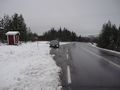
The car parked at the bus stop.
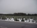
Looking towards the hashpoint... it is in that tall forest, about 280 metres away.
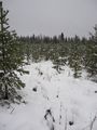
My track in the snow about halfway to the hashpoint.
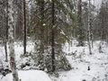
The hashpoint was approximately at that spruce tree.
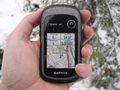
Hashpoint reached.
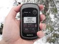
Proof of date and time.
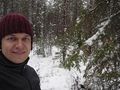
Selfie at the hashpoint.


Achievements
Kripakko earned the Land geohash achievement
|