Difference between revisions of "2020-11-19 52 9"
From Geohashing
(New Report) |
m (Adding hours) |
||
| (2 intermediate revisions by 2 users not shown) | |||
| Line 33: | Line 33: | ||
{{bicycle geohash|date=2020-11-19|latitude=52|longitude=9|name=[[User:Fippe|Fippe]]|distance=24 km|bothways=true|image=2020-11-19 52 9 07 Bicycle.jpg}} | {{bicycle geohash|date=2020-11-19|latitude=52|longitude=9|name=[[User:Fippe|Fippe]]|distance=24 km|bothways=true|image=2020-11-19 52 9 07 Bicycle.jpg}} | ||
{{sunrise geohash|date=2020-11-19|latitude=52|longitude=9|name=[[User:Fippe|Fippe]]}} | {{sunrise geohash|date=2020-11-19|latitude=52|longitude=9|name=[[User:Fippe|Fippe]]}} | ||
| + | {{last man standing|date=2020-11-19|latitude=52|longitude=9|name=[[User:Fippe|Fippe]]}} | ||
__NOTOC__ | __NOTOC__ | ||
| Line 39: | Line 40: | ||
[[Category:Expeditions with photos]] | [[Category:Expeditions with photos]] | ||
{{location|DE|NI|H}} | {{location|DE|NI|H}} | ||
| − | + | {{user categories|user=Fippe|bike=24|hours=07}} | |
Latest revision as of 19:32, 11 December 2022
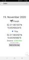
| Thu 19 Nov 2020 in Hannover: 52.3118018, 9.6929063 geohashing.info google osm bing/os kml crox |
Location
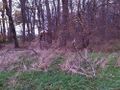
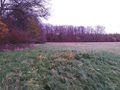
This Geohash is located on the edge between a forest and a meadow near Ronnenberg.
Participants
Expedition
I took the bicycle to Devese in the morning. The coordinates were located behind the municipal border on Ronnenberg territory. I entered the forest near the Geohash from the north and located the coordinates a few steps outside the forest on the adjacent meadow. As I reached the coordinates the sun was supposed to rise, but I couldn't see it since the forest blocked my view to the east and it was cloudy anyway. After recording proof, I went back to my bicycle and left the forest, this time to the south, and rode back home again.
Photos
Proof
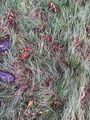
The Geohash
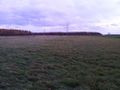
Surroundings
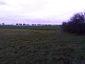
Surroundings
Surroundings
Surroundings
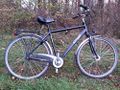
My bicycle near the Geohash
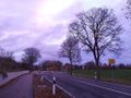
In Devese


Ribbons
Fippe earned the Land geohash achievement
|
Fippe earned the Bicycle geohash achievement
|
Fippe earned the Sunrise Geohash Achievement
|
Fippe earned the Last man standing achievement
|