Difference between revisions of "2020-11-21 53 10"
(Moving MikroKosmos's expedition from Template:Expedition Images2/2020-11-21 to here.) |
(→π π π: "shortly") |
||
| (5 intermediate revisions by 3 users not shown) | |||
| Line 5: | Line 5: | ||
==Participants== | ==Participants== | ||
| − | *[[User:π π π|π π π]] ([[User talk: | + | *[[User:π π π|π π π]] ([[User talk:π π π|talk]]) |
*[[User:MikroKosmos|MikroKosmos]] | *[[User:MikroKosmos|MikroKosmos]] | ||
==Plans== | ==Plans== | ||
| − | |||
| − | |||
| − | |||
===MikroKosmos=== | ===MikroKosmos=== | ||
Try to reach my first geohash-point. | Try to reach my first geohash-point. | ||
| Line 21: | Line 18: | ||
Then I was just at the coordinates N53° 40.291 E010° 02.279. | Then I was just at the coordinates N53° 40.291 E010° 02.279. | ||
I took some photos and then went without leaving anything but traces. | I took some photos and then went without leaving anything but traces. | ||
| + | New to this sport, I did not have the meetup time in mind, but I was there short | ||
| + | after 16:00, on my last photo my watch shows 16:13. | ||
| + | |||
| + | ==π π π== | ||
| + | My first regular expedition where someone else also showed up (though not at the same time)! Welcome, MikroKosmos! In retrospect, maybe I shouldn’ve left just before the meetup time, but I didn‘t expect anyone else to come at all. | ||
| + | |||
| + | I took the train to Kiwittsmoor and then cycled 2.5 km to the hash, managing to take two wrong turns on the way. I left my bike on the path, jumped over a ditch to get to a frequented dogwalking path. I considered waiting until nobody looked, but that would have taken some time, so I just paced across the field in plain sight and entered a small stretch of forest. I walked through it for about 70 m until I found a good spot to cross the next ditch and enter the field of the geohash. 35 m across the grass, I found the location and took pictures, then walked 160 m back to my bike, crossing a fence, some undergrowth and the first ditch again. Then I wanted to head back to Kiwittsmoor, but missed my turn and ended up accidentally cycling 2.7 km to Langenhorn Nord station, where I saw my train leave as I arrived, so I had to wait for the next one. | ||
==Photos== | ==Photos== | ||
| + | |||
===MikroKosmos=== | ===MikroKosmos=== | ||
<gallery> | <gallery> | ||
Geohash20201121a.jpg | Proof | Geohash20201121a.jpg | Proof | ||
Geohash20201121b.jpg | the view | Geohash20201121b.jpg | the view | ||
| + | [[File:Geohash20201121c.jpg|thumb|Geohash20201121c]] | ||
</gallery> | </gallery> | ||
| − | + | ===π π π=== | |
| − | + | <gallery> | |
| − | <gallery | + | File:2020-11-21 53 10 7.jpg | proof |
| + | File:2020-11-21 53 10 8.jpg | coords | ||
| + | File:2020-11-21 53 10 5.jpg | π π π | ||
| + | File:2020-11-21 53 10 6.jpg | ditch along path | ||
| + | File:2020-11-21 53 10 1.jpg | the hash | ||
| + | File:2020-11-21 53 10 2.jpg | pano 1 | ||
| + | File:2020-11-21 53 10 3.jpg | pano 2 | ||
</gallery> | </gallery> | ||
==Achievements== | ==Achievements== | ||
| − | Land geohash, Bicycle geohash, Public transport geohash-- | + | Land geohash, Bicycle geohash (π π π), Public transport geohash (π π π) |
| + | |||
| + | {{Two to the N achievement | ||
| + | | count = 6 | ||
| + | | date = 2020-11-21 | ||
| + | | latitude = 53 | ||
| + | | longitude = 10 | ||
| + | | name = π π π | ||
| + | }} | ||
__NOTOC__ | __NOTOC__ | ||
| Line 41: | Line 61: | ||
[[Category:Coordinates reached]] | [[Category:Coordinates reached]] | ||
[[Category:Land geohash achievement]] | [[Category:Land geohash achievement]] | ||
| − | |||
[[Category:Bicycle geohash achievement]] | [[Category:Bicycle geohash achievement]] | ||
| − | [[Category:Public transport geohash achievement]] | + | [[Category:Public transport geohash achievement]] |
{{location|DE|HH}} | {{location|DE|HH}} | ||
Latest revision as of 16:36, 6 September 2022
| Sat 21 Nov 2020 in 53,10: 53.6715242, 10.0379915 geohashing.info google osm bing/os kml crox |
Location
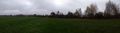
on a large field in Hamburg-Hummelsbüttel
Participants
Plans
MikroKosmos
Try to reach my first geohash-point. Today it is near and on a field.
Expedition
MikroKosmos
I followed walking trails, crossed a stubble field (100m) and went on a field of grass (20m). Then I was just at the coordinates N53° 40.291 E010° 02.279. I took some photos and then went without leaving anything but traces. New to this sport, I did not have the meetup time in mind, but I was there short after 16:00, on my last photo my watch shows 16:13.
π π π
My first regular expedition where someone else also showed up (though not at the same time)! Welcome, MikroKosmos! In retrospect, maybe I shouldn’ve left just before the meetup time, but I didn‘t expect anyone else to come at all.
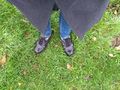
I took the train to Kiwittsmoor and then cycled 2.5 km to the hash, managing to take two wrong turns on the way. I left my bike on the path, jumped over a ditch to get to a frequented dogwalking path. I considered waiting until nobody looked, but that would have taken some time, so I just paced across the field in plain sight and entered a small stretch of forest. I walked through it for about 70 m until I found a good spot to cross the next ditch and enter the field of the geohash. 35 m across the grass, I found the location and took pictures, then walked 160 m back to my bike, crossing a fence, some undergrowth and the first ditch again. Then I wanted to head back to Kiwittsmoor, but missed my turn and ended up accidentally cycling 2.7 km to Langenhorn Nord station, where I saw my train leave as I arrived, so I had to wait for the next one.
Photos
MikroKosmos
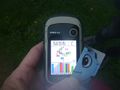
Proof
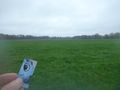
the view


π π π
proof
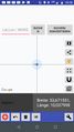
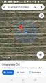
coords
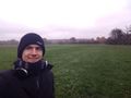
π π π
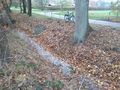
ditch along path
the hash
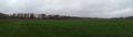
pano 1
pano 2


Achievements
Land geohash, Bicycle geohash (π π π), Public transport geohash (π π π)
