Difference between revisions of "2020-12-29 33 -112"
m (→Location) |
(→Expedition) |
||
| (13 intermediate revisions by 2 users not shown) | |||
| Line 18: | Line 18: | ||
== Participants == | == Participants == | ||
| − | |||
| − | |||
| − | + | [[User:Lyricalcarpenter|Lyricalcarpenter]] ([[User talk:Lyricalcarpenter|talk]]) | |
| − | |||
== Expedition == | == Expedition == | ||
| − | + | Upon arriving, there were many more people walking around the neighborhood than expected. I took my first picture between the third and fourth houses, where I remembered the geohash to be positioned. While checking on Peeron to make sure that I had correctly located the hash, the people who lived in those houses wanted to pull into their driveway. I was obligated to pull over onto a side road and check the picture, which ''wasn't even the picture of the hashpoint.'' | |
| − | + | Remember how I said the hashpoint was in between the third and fourth houses? It wasn't. It was located between the second and third houses. I didn't notice this because of the positioning of the local shrubbery, which I remembered from planning. I was forced to scrap the original picture, drive around the street again, and take a new picture. | |
| − | |||
| − | + | In the picture, you can see me trying to hold a Crox Poster. I say "trying" because at the moment I took the picture a crosswind started blowing the paper around. I had to try for three minutes to get the poster in the right field of view before I was satisfied, and went home. | |
| − | + | ||
| − | + | The reason that I didn't just tape the poster to the ground or something is that everybody in the neighborhood was out watching me make a fool of myself. Since geohashing is mostly a law-abiding sport, I didn't want to leave a piece of paper just laying on the ground in view of everyone. | |
| − | + | ||
| + | Even if this claim is disputed somehow, I drove up and down the road so many times that I must have hit the hash at some point. | ||
| + | |||
| + | == Photos == | ||
<gallery perrow="5"> | <gallery perrow="5"> | ||
| + | File:LC 2020-12-29 33 -112.jpg|thumb|Littering is bad.™ | ||
</gallery> | </gallery> | ||
== Achievements == | == Achievements == | ||
| + | |||
{{#vardefine:ribbonwidth|800px}} | {{#vardefine:ribbonwidth|800px}} | ||
| − | |||
| − | + | {{land geohash | |
| − | |||
| − | |||
| − | + | | latitude = 33 | |
| + | | longitude = -112 | ||
| + | | date = 2020-12-29 | ||
| + | | name = lyricalcarpenter | ||
| + | }} | ||
| + | {{Two to the N achievement | ||
| − | + | | count = 0 | |
| − | + | | date = 2020-12-29 | |
| − | + | | latitude = 33 | |
| − | + | | longitude = -112 | |
| + | | name = lyricalcarpenter | ||
| + | | reached = true | ||
| + | }} | ||
| − | + | [[Category:Expeditions]] | |
| − | |||
| − | |||
| − | |||
[[Category:Expeditions with photos]] | [[Category:Expeditions with photos]] | ||
| − | + | ||
| − | |||
| − | |||
| − | |||
| − | |||
[[Category:Coordinates reached]] | [[Category:Coordinates reached]] | ||
| − | + | {{location|US|AZ|MA}} | |
| − | |||
| − | |||
| − | |||
| − | |||
| − | |||
| − | |||
| − | |||
| − | |||
| − | |||
| − | |||
| − | |||
| − | |||
| − | |||
| − | |||
| − | |||
| − | |||
| − | |||
Latest revision as of 01:33, 24 January 2021
| Tue 29 Dec 2020 in 33,-112: 33.6677735, -112.1475106 geohashing.info google osm bing/os kml crox |
Location
On the north side of West Escuda Dr in Glendale.
Participants
Expedition
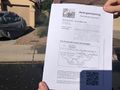
Upon arriving, there were many more people walking around the neighborhood than expected. I took my first picture between the third and fourth houses, where I remembered the geohash to be positioned. While checking on Peeron to make sure that I had correctly located the hash, the people who lived in those houses wanted to pull into their driveway. I was obligated to pull over onto a side road and check the picture, which wasn't even the picture of the hashpoint.
Remember how I said the hashpoint was in between the third and fourth houses? It wasn't. It was located between the second and third houses. I didn't notice this because of the positioning of the local shrubbery, which I remembered from planning. I was forced to scrap the original picture, drive around the street again, and take a new picture.
In the picture, you can see me trying to hold a Crox Poster. I say "trying" because at the moment I took the picture a crosswind started blowing the paper around. I had to try for three minutes to get the poster in the right field of view before I was satisfied, and went home.
The reason that I didn't just tape the poster to the ground or something is that everybody in the neighborhood was out watching me make a fool of myself. Since geohashing is mostly a law-abiding sport, I didn't want to leave a piece of paper just laying on the ground in view of everyone.
Even if this claim is disputed somehow, I drove up and down the road so many times that I must have hit the hash at some point.
Photos
Littering is bad.™

Achievements
lyricalcarpenter earned the Land geohash achievement
|
