Difference between revisions of "2021-01-08 49 8"
m (Fippe moved page 2021-01-08 49 08 to 2021-01-08 49 8) |
Gefrierbrand (talk | contribs) |
||
| (6 intermediate revisions by 3 users not shown) | |||
| Line 14: | Line 14: | ||
__NOTOC__ | __NOTOC__ | ||
== Location == | == Location == | ||
| − | + | On top of a fallen down treetrunk slightly offroad in a small forest near Eberstadt. | |
== Participants == | == Participants == | ||
| − | + | *[[User:Gefrierbrand|Gefrierbrand]] | |
| − | + | *[[User:Santu|Santu]] | |
| + | *Pedro (the dog) | ||
== Plans == | == Plans == | ||
| − | + | We noticed that the Hashpoint was relatively close to Santus home and also almost exactly due west in an accessible forest. As we had plans to walk the dog anyway, we decided it was finally time to go geohashing together, the fist one ever for Santu. We had previously discussed the possibility for achievements and noticed the almost perfect conditions for a juggernaut run. It was however surprisingly difficult to find good mapping tools online which show the deviation from a straight line. But we eventually managed to find a route with would stay within the limits and decided to give it a shot. As we knew it would get cold and dark we prepared flashlights, warm clothes and some emergency rations well as more than enough treats for the dog. | |
== Expedition == | == Expedition == | ||
| − | + | This was a great and fun experience! We knew the paths pretty well from our planning sessions and also had transferred it to a handheld GPS device for reference. In theory we should not need to step out of our maximum allowed tolerance for the Juggernaut attempt if we followed that path correctly, which meant crossing some smaller forests and hedges on relatively steep terrain. Fortunately enough we could stay on farm tracks or other nice to walk on paths for most of the way. While we were overtaken by another person waling the dog we built a very small snowman to use the last moments of light before we ventured on into the dusk and eventually darkness. We had to overcome one smaller fence and Gefrierbrand, who went first, promptly managed to fall over in a unharmful, but hilarious way. We also encountered a nice lady who was startled at first, but then happy to show us an opening through the quite thick bushes. After that we basically only had to walk in a straight line right along the roads in Eberstadt to finally arrive in the targeted forest. Our Flashlights were quite helpful there and we declared the Hashpoint to be on a nice, snowcovered log which was within the GPS accuracy. Naturally we had to climb on it and that time no one fell down. We then contemplated using the bus to get back, but since we would have had to wait almost as long as walking we used our feet to get home again. | |
== Tracklog == | == Tracklog == | ||
| − | + | {{tracklog|T2021-01-08-17-45.gpx}} | |
== Photos == | == Photos == | ||
| − | |||
| − | |||
| − | |||
<gallery perrow="5"> | <gallery perrow="5"> | ||
| + | Image:2021-01-08_49_8_expeditionstart.jpg | Time to start in a snow covered adventure | ||
| + | Image:2021-01-08_49_8_treatthedog.jpg | Pedro needs his treats | ||
| + | Image:2021-01-08_49_8_snowman.jpg | little snowman on the way | ||
| + | Image:2021-01-08_49_8_downthisway.jpg | This was about 30° downhill | ||
| + | Image:2021-01-08_49_8_coordinatesreached.jpg | proof | ||
| + | Image:2021-01-08_49_8_stupidgrin.jpg | StupidGrin<sup>TM</sup> in the shine of our flashlight. | ||
| + | Image:2021-01-08_49_8_pathanddeviation.jpg | The maximum deviation from the straight line was 147 m | ||
</gallery> | </gallery> | ||
== Achievements == | == Achievements == | ||
{{#vardefine:ribbonwidth|800px}} | {{#vardefine:ribbonwidth|800px}} | ||
| − | + | {{land geohash | |
| − | + | | latitude = 49 | |
| − | + | | longitude = 8 | |
| − | + | | date = 2021-01-08 | |
| − | + | | name = Gefrierbrand & Santu | |
| − | + | }} | |
| − | + | {{Juggernaut achievement | |
| − | + | | latitude = 49 | |
| − | + | | longitude = 8 | |
| − | + | | date = 2021-01-08 | |
| − | + | | deviation= 29 | |
| − | + | | name = Gefrierbrand & Santu | |
| − | + | }} | |
| − | + | {{Walk geohash | |
| − | + | | latitude = 49 | |
| − | + | | longitude = 8 | |
| + | | date = 2021-01-08 | ||
| + | | name = Gefrierbrand & Santu | ||
| + | | distance = 5.3 km | ||
| + | }} | ||
| + | {{Last man standing | ||
| + | | latitude = 49 | ||
| + | | longitude = 8 | ||
| + | | date = 2021-01-08 | ||
| + | | gender = couple | ||
| + | | name = Gefrierbrand & Santu | ||
| + | }} | ||
[[Category:Expeditions]] | [[Category:Expeditions]] | ||
| − | |||
| − | |||
| − | |||
| − | |||
| − | |||
| − | |||
| − | |||
[[Category:Coordinates reached]] | [[Category:Coordinates reached]] | ||
| − | + | [[Category:Expeditions with dogs]] | |
| − | + | {{location|DE|HE|DA|city=true}} | |
| − | |||
| − | |||
| − | |||
| − | |||
| − | |||
| − | |||
| − | |||
| − | |||
| − | |||
| − | |||
| − | [[Category: | ||
| − | |||
| − | |||
| − | |||
| − | |||
| − | |||
Latest revision as of 07:53, 18 October 2022
| Fri 8 Jan 2021 in 49,8: 49.8213431, 8.6343501 geohashing.info google osm bing/os kml crox |
Location
On top of a fallen down treetrunk slightly offroad in a small forest near Eberstadt.
Participants
- Gefrierbrand
- Santu
- Pedro (the dog)
Plans
We noticed that the Hashpoint was relatively close to Santus home and also almost exactly due west in an accessible forest. As we had plans to walk the dog anyway, we decided it was finally time to go geohashing together, the fist one ever for Santu. We had previously discussed the possibility for achievements and noticed the almost perfect conditions for a juggernaut run. It was however surprisingly difficult to find good mapping tools online which show the deviation from a straight line. But we eventually managed to find a route with would stay within the limits and decided to give it a shot. As we knew it would get cold and dark we prepared flashlights, warm clothes and some emergency rations well as more than enough treats for the dog.
Expedition
This was a great and fun experience! We knew the paths pretty well from our planning sessions and also had transferred it to a handheld GPS device for reference. In theory we should not need to step out of our maximum allowed tolerance for the Juggernaut attempt if we followed that path correctly, which meant crossing some smaller forests and hedges on relatively steep terrain. Fortunately enough we could stay on farm tracks or other nice to walk on paths for most of the way. While we were overtaken by another person waling the dog we built a very small snowman to use the last moments of light before we ventured on into the dusk and eventually darkness. We had to overcome one smaller fence and Gefrierbrand, who went first, promptly managed to fall over in a unharmful, but hilarious way. We also encountered a nice lady who was startled at first, but then happy to show us an opening through the quite thick bushes. After that we basically only had to walk in a straight line right along the roads in Eberstadt to finally arrive in the targeted forest. Our Flashlights were quite helpful there and we declared the Hashpoint to be on a nice, snowcovered log which was within the GPS accuracy. Naturally we had to climb on it and that time no one fell down. We then contemplated using the bus to get back, but since we would have had to wait almost as long as walking we used our feet to get home again.
Tracklog
Photos
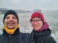
Time to start in a snow covered adventure
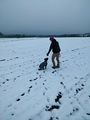
Pedro needs his treats
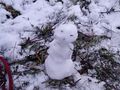
little snowman on the way
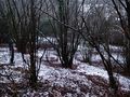
This was about 30° downhill
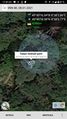
proof
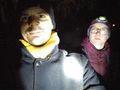
StupidGrinTM in the shine of our flashlight.
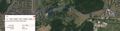
The maximum deviation from the straight line was 147 m


Achievements
Gefrierbrand & Santu earned the Land geohash achievement
|
Gefrierbrand & Santu earned the Juggernaut achievement
|
Gefrierbrand & Santu earned the Walk geohash Achievement
|
Gefrierbrand & Santu earned the Last couple standing achievement
|