Difference between revisions of "2021-01-16 52 4"
FelixTheCat (talk | contribs) (Created page with "{{subst:Expedition |lat = 52 |lon = 4 |date = 2021-01-16 }}") |
FelixTheCat (talk | contribs) |
||
| Line 1: | Line 1: | ||
| − | + | {{meetup graticule | |
| − | |||
| − | |||
| − | |||
| − | |||
| − | |||
| − | |||
| − | |||
| − | |||
| lat=52 | | lat=52 | ||
| lon=4 | | lon=4 | ||
| date=2021-01-16 | | date=2021-01-16 | ||
| − | }} | + | }} |
__NOTOC__ | __NOTOC__ | ||
== Location == | == Location == | ||
| − | + | Westerpark, Zoetermeer, South Holland province. | |
== Participants == | == Participants == | ||
| − | + | * [[User:FelixTheCat|FelixTheCat]] ([[User talk:FelixTheCat|talk]]) | |
| − | + | * Kat the Awesome | |
| − | |||
| − | |||
| − | |||
== Expedition == | == Expedition == | ||
| − | + | The hash was in a park on the western edge of Zoetermeer, about 10 km from our house. It was quite cold, about 2 degrees C, but Kat and I were not te be deterred and decided to ride our bikes. We rode through Nootdorp, crossed the A12 motorway and arrived in Zoetermeer. It was a nice park, with trees, lots of grass, several lakes and even some small hills. We parked our bikes and walked the last 150 metres to reach the point. After taking the required photos I picked up two empty vodka bottles and put them in a trashcan. Then we returned to our bikes and rode back home again. On the way back it began to snow, for the first time this winter. It made for beautiful surroundings but rather unpleasant cycling. We got home safely and made ourselves a nice cup of tea. | |
| − | |||
| − | |||
| − | |||
== Photos == | == Photos == | ||
| − | |||
| − | |||
| − | |||
<gallery perrow="5"> | <gallery perrow="5"> | ||
| + | Image:2021-01-16 52 4 FelixTheCat 1.JPG | The tunnel we used to cross the A12 motorway (in front) and the Gouda-Den Haag railway line (at rear, with train passing by). | ||
| + | Image:2021-01-16 52 4 FelixTheCat 2.JPG | At the edge of Zoetermeer. The park is behind those trees up ahead. | ||
| + | Image:2021-01-16 52 4 FelixTheCat 3.JPG | In the park. | ||
| + | Image:2021-01-16 52 4 FelixTheCat 4.JPG | Approaching the hash. | ||
| + | Image:2021-01-16 52 4 FelixTheCat 5.png | Made it! We're still on dry land; the edge of the water is not recorded very accurately on the map. | ||
| + | Image:2021-01-16 52 4 FelixTheCat 6.JPG | Lloyd and Hermelien the elephant celebrating. | ||
| + | Image:2021-01-16 52 4 FelixTheCat 7.JPG | Looking at the water. There's an empty vodka bottle on the ground, and another one bobbing in the water. | ||
| + | Image:2021-01-16 52 4 FelixTheCat 8.JPG | So I did the right thing and picked them up... | ||
| + | Image:2021-01-16 52 4 FelixTheCat 9.JPG | ...and put them in the bin. | ||
</gallery> | </gallery> | ||
== Achievements == | == Achievements == | ||
{{#vardefine:ribbonwidth|800px}} | {{#vardefine:ribbonwidth|800px}} | ||
| − | + | {{bicycle geohash | |
| − | + | | latitude = 52 | |
| − | + | | longitude = 4 | |
| − | + | | date = 2021-01-16 | |
| − | [[ | + | | name = [[User:FelixTheCat|FelixTheCat]] ([[User talk:FelixTheCat|talk]]) and Kat |
| − | + | | distance = 21 km | |
| − | + | | bothways = true | |
| − | + | }} | |
| − | + | {{Geotrash | |
| − | + | | latitude = 52 | |
| − | + | | longitude = 4 | |
| − | -- | + | | date = 2021-01-16 |
| − | + | | name = [[User:FelixTheCat|FelixTheCat]] ([[User talk:FelixTheCat|talk]]) | |
| − | + | }} | |
| − | |||
| − | |||
[[Category:Expeditions]] | [[Category:Expeditions]] | ||
| − | |||
[[Category:Expeditions with photos]] | [[Category:Expeditions with photos]] | ||
| − | |||
| − | |||
| − | |||
| − | |||
| − | |||
[[Category:Coordinates reached]] | [[Category:Coordinates reached]] | ||
| − | |||
| − | |||
| − | |||
| − | |||
| − | |||
| − | |||
| − | |||
| − | |||
| − | |||
| − | |||
| − | |||
| − | |||
| − | |||
| − | |||
| − | |||
| − | |||
| − | |||
| − | |||
Revision as of 20:54, 16 January 2021
| Sat 16 Jan 2021 in 52,4: 52.0555456, 4.4445563 geohashing.info google osm bing/os kml crox |
Location
Westerpark, Zoetermeer, South Holland province.
Participants
- FelixTheCat (talk)
- Kat the Awesome
Expedition
The hash was in a park on the western edge of Zoetermeer, about 10 km from our house. It was quite cold, about 2 degrees C, but Kat and I were not te be deterred and decided to ride our bikes. We rode through Nootdorp, crossed the A12 motorway and arrived in Zoetermeer. It was a nice park, with trees, lots of grass, several lakes and even some small hills. We parked our bikes and walked the last 150 metres to reach the point. After taking the required photos I picked up two empty vodka bottles and put them in a trashcan. Then we returned to our bikes and rode back home again. On the way back it began to snow, for the first time this winter. It made for beautiful surroundings but rather unpleasant cycling. We got home safely and made ourselves a nice cup of tea.
Photos
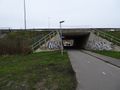
The tunnel we used to cross the A12 motorway (in front) and the Gouda-Den Haag railway line (at rear, with train passing by).
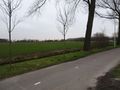
At the edge of Zoetermeer. The park is behind those trees up ahead.
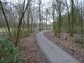
In the park.
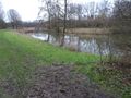
Approaching the hash.
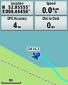
Made it! We're still on dry land; the edge of the water is not recorded very accurately on the map.
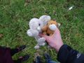
Lloyd and Hermelien the elephant celebrating.
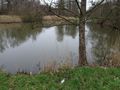
Looking at the water. There's an empty vodka bottle on the ground, and another one bobbing in the water.
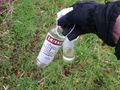
So I did the right thing and picked them up...
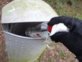
...and put them in the bin.


Achievements
FelixTheCat (talk) and Kat earned the Bicycle geohash achievement
|
FelixTheCat (talk) earned the GeoTrash Geohash Achievement
|