Difference between revisions of "2021-02-09 49 8"
Gefrierbrand (talk | contribs) |
Gefrierbrand (talk | contribs) |
||
| (12 intermediate revisions by 3 users not shown) | |||
| Line 1: | Line 1: | ||
| − | + | {{meetup graticule | |
| − | |||
| − | |||
| − | |||
| − | |||
| − | |||
| − | |||
| − | |||
| − | |||
| lat=49 | | lat=49 | ||
| lon=8 | | lon=8 | ||
| date=2021-02-09 | | date=2021-02-09 | ||
| − | }} | + | }} |
__NOTOC__ | __NOTOC__ | ||
== Location == | == Location == | ||
| − | in a swampy | + | in a swampy forest near Darmstadt |
== Participants == | == Participants == | ||
| − | [[User:Gefrierbrand|Gefrierbrand]] | + | *[[User:Gefrierbrand|Gefrierbrand]] |
| − | + | *[[User:Santu|Santu]] | |
| + | *Pedro the dog | ||
== Plans == | == Plans == | ||
| − | + | Drive near the hash, walk into the forest, explore the surrounding area. | |
| + | == Expedition == | ||
| + | This was a very spontaneous expedition. Even with the hash being only about 9km (straight line distance) away from Santus home, we had not intended to go Geohashing on this day. But as Gefrierbrand entered the details of the previous expedition, he noticed the cool Picture of [[2021-02-06 62 29|Kripakkos Expedition]] and mentioned the cold weather. Santu looked outside and said "it's freezing now!". As we had just missed the freezing achievement earlier, we had to change plans immediately and prepared us and the dog for an impromptu adventure. | ||
| − | + | We then drove to a paddock near a small lake in the general area, collected a geocache directly at its shore and then walked towards the small forest. We had no trouble locating the hashpoint, but traversing there was harder than anticipated since the ground was not frozen and very muddy and damp. While there were several puddles, some even with frozen ice layers on top, the walking on water achievement as to wait for another time. | |
| − | |||
| + | We took pictures and temperature readings and then proceeded to the nearby Jagdschloss Kranichstein. Even with our thick clothes it was too cold for a nice longer walk and we headed back back into the warm home quite quickly. | ||
== Photos == | == Photos == | ||
| − | |||
| − | |||
| − | |||
<gallery perrow="5"> | <gallery perrow="5"> | ||
| + | Image:2021-02-09_49_8_Gefrierbrand_1612947074107.jpg|Jagdschloss Kranichstein | ||
| + | Image:2021-02-09_49_8_Gefrierbrand_1612947105133.jpg|Frozen | ||
| + | Image:2021-02-09_49_8_Gefrierbrand_1612947131202.jpg|proof | ||
| + | Image:2021-02-09_49_8_Gefrierbrand_1612947158691.jpg|stupid grin<sup>TM</sup> | ||
| + | Image:2021-02-09_49_8_Gefrierbrand_1612947199621.jpg|playing in the snow | ||
| + | Image:2021-02-09_49_8_Gefrierbrand_1612947241003.jpg|muddier than it looks | ||
</gallery> | </gallery> | ||
== Achievements == | == Achievements == | ||
{{#vardefine:ribbonwidth|800px}} | {{#vardefine:ribbonwidth|800px}} | ||
| − | + | {{land geohash | |
| − | + | | latitude = 49 | |
| − | + | | longitude = 8 | |
| − | + | | date = 2021-02-09 | |
| − | + | | name = Gefrierbrand & Santu | |
| − | + | }} | |
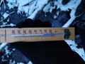
| − | + | {{Frozen Geohash | |
| − | + | | latitude = 49 | |
| − | + | | longitude = 8 | |
| − | + | | date = 2021-02-09 | |
| − | + | | temperature = -4 °C | |
| − | + | | name = Gefrierbrand & Santu | |
| − | + | }} | |
| − | + | {{Hash collision | |
| + | | latitude = 49 | ||
| + | | longitude = 8 | ||
| + | | date = 2021-02-09 | ||
| + | | name = Gefrierbrand & Santu | ||
| + | | id = GC6YA78 | ||
| + | | distance = 265m | ||
| + | | honor = honorable mention | ||
| + | }} | ||
| − | |||
[[Category:Expeditions]] | [[Category:Expeditions]] | ||
| − | |||
[[Category:Expeditions with photos]] | [[Category:Expeditions with photos]] | ||
| − | |||
| − | |||
| − | |||
| − | |||
| − | |||
[[Category:Coordinates reached]] | [[Category:Coordinates reached]] | ||
| − | + | [[Category:Expeditions with dogs]] | |
| − | + | {{location|DE|HE|DA|city=true}} | |
| − | |||
| − | |||
| − | |||
| − | |||
| − | |||
| − | |||
| − | |||
| − | |||
| − | |||
| − | |||
| − | [[Category: | ||
| − | |||
| − | |||
| − | |||
| − | |||
| − | |||
Latest revision as of 07:53, 18 October 2022
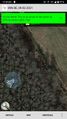
| Tue 9 Feb 2021 in 49,8: 49.8971011, 8.6898974 geohashing.info google osm bing/os kml crox |
Location
in a swampy forest near Darmstadt
Participants
- Gefrierbrand
- Santu
- Pedro the dog
Plans
Drive near the hash, walk into the forest, explore the surrounding area.
Expedition
This was a very spontaneous expedition. Even with the hash being only about 9km (straight line distance) away from Santus home, we had not intended to go Geohashing on this day. But as Gefrierbrand entered the details of the previous expedition, he noticed the cool Picture of Kripakkos Expedition and mentioned the cold weather. Santu looked outside and said "it's freezing now!". As we had just missed the freezing achievement earlier, we had to change plans immediately and prepared us and the dog for an impromptu adventure.
We then drove to a paddock near a small lake in the general area, collected a geocache directly at its shore and then walked towards the small forest. We had no trouble locating the hashpoint, but traversing there was harder than anticipated since the ground was not frozen and very muddy and damp. While there were several puddles, some even with frozen ice layers on top, the walking on water achievement as to wait for another time.
We took pictures and temperature readings and then proceeded to the nearby Jagdschloss Kranichstein. Even with our thick clothes it was too cold for a nice longer walk and we headed back back into the warm home quite quickly.
Photos

Jagdschloss Kranichstein
Frozen
proof
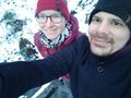
stupid grinTM
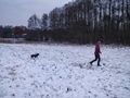
playing in the snow
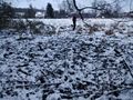
muddier than it looks


Achievements
Gefrierbrand & Santu earned the Land geohash achievement
|

Gefrierbrand & Santu earned the Hash collision honorable mention
|