2021-02-06 62 29
| Sat 6 Feb 2021 in 62,29: 62.7667093, 29.8028228 geohashing.info google osm bing/os kml crox |
Location
In lake Höytiäinen, nearly a kilometre from the nearest shore.
Participants
Expedition
I devised a plan to take the bus 202 from Joensuu to Kontiolahti and to ski to the hashpoint. I would also have to ski from my home to the bus stop and back on my way home. The bus runs hourly, so I would have one hour (overly optimistic, would require perfect conditions) or two (definitely possible) to visit the hashpoint. I applied some anti-icing agent to the bottoms of my nano-coated skis[1], dressed up excessively warmly and set off. The weather was beautiful: −11 °C, partly cloudy and not snowing at all.
I was able to ski almost all the way (some 1.4 km) to the bus stop. There has been enough snowfall in constant frost that most roads have not been gritted recently. It is not necessary because the cold snow is dry and not slippery at all. It also offers sufficient friction for classic-style skiing and nice slide so that it was convenient to move forward at about jogging speed. I am not a fast skier by any means, and in this winter I have been lazy and not skied yet, so my technique is still rusty.
I got on the bus at about 11:30, and it arrived in Kontiolahti at 12:00. I was able to walk and ski the first 1.4 km to the lakeshore in only ten minutes, greatly aided by the 35-metre vertical descent in the last 800 metres. I entered the lake at Vierevänniemi beach, and there I realised that there was a thick layer of powder snow on the ice that would be slow to traverse. I would not be able to make it back to the bus station by 13:05, when the next bus would leave, so I would aim to the next one at 14:05. There was also some water on the ice in some places, which caused slight buildup of ice to my skis despite the anti-icing agent. Of course, without it, the skis would have iced up almost instantly and become useless for skiing. The little ice was no problem because I could scrape it off either manually or by skiing over hard frozen snow which existed in some places.
I first followed a wide convenient track with no loose snow that took me close to the islands at 62.769, 29.814. Then I took the straight path towards the hashpoint, clearing a trail in the 10-cm deep powder snow. I reached the hashpoint surprisingly easily despite having no landmarks to help me. I missed the point by some 20 metres over a distance of about 550 metres. Maybe I have developed some orienteer's instinct with which I can stay in course and estimate distances rather well. I took a few pictures and headed back for the islands.
I went and found the geocache Ahku on the smaller island. The straight distance between it and the hashpoint was 655 metres. I wonder if I am eligible for the Hash collision achievement with this one. According to the achievement page, the geocache should be visible from the geohash site, and this one, while on the far side of the island, was on the side of a tree that would theoretically be visible to the hashpoint, though it would have required a telescope to actually see it. On the other hand, someone at the geocache site would easily have seen a person standing at the geohash because it lies on the open lake. Well, in any case I can at least claim an honourable mention.
Next, I skied to the nearest shore and found the geocache Rantaongintaa. I could have entered the mainland there and skied back to the road, but the trails were snowy enough that I decided I would be better off skiing back to Vierevänniemi beach on paths and roads that I knew to be traversable. I climbed up the previous descent and returned to the bus station at 13:55, nicely in time to catch the bus. When I took the skis off, I noticed that there were large buildups of ice on the sides and the tops where it was never scraped off and some little specs of ice on the bottoms too. Also, the bottoms of the skis are gradually falling apart due to the many twigs and pieces of gravel that I have skied over during the years. I travelled back to Joensuu, visited a grocery store and skied home. I ended up skiing about 8.0 km and walking about 2.1 km in total, a nice daily physical exercise.
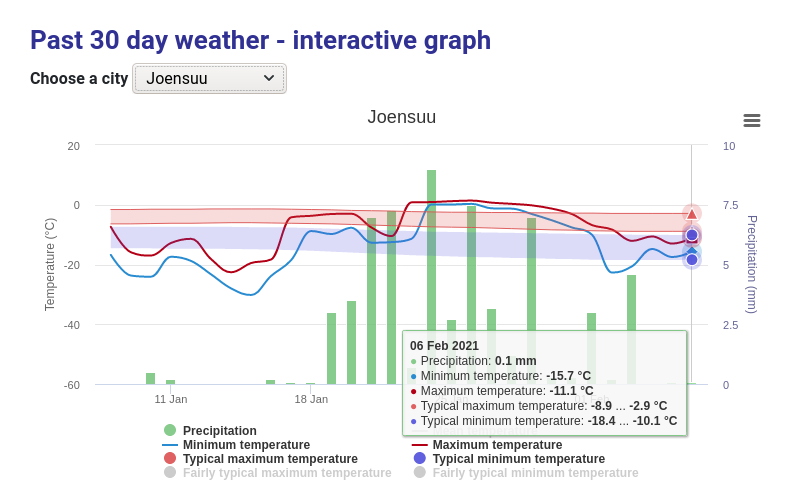
I did not record the temperature because I do not have a portable thermometer that could measure this low temperatures. However, all weather forecasts that I saw predicted a high temperature of −11 °C for the day. Weather reports are consistent with this: newspaper Karjalainen reports −12 °C in Joensuu and −11 °C in Juuka, Kontiolahti being in the middle of them, the Finnish Meteorological Institute[2] reports −11.1 °C in Joensuu and AccuWeather.com reports −10 °C in Kontiolahti. Therefore, I can quite confidently call it −11 °C.
Photos
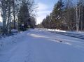
The bus stop, waiting for the bus.
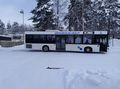
The bus, at the terminus in Kontiolahti.
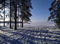
Vierevänniemi beach, used as an easy access point to the lake in the winter.
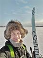
Selfie at the hashpoint.
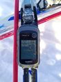
Proof of location.

Proof of date and time.
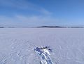
X marks the spot.
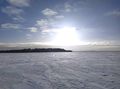
The sun shining in an almost clear sky.
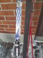
How the skis looked like after getting back to the bus terminus in Kontiolahti.


Achievements
Kripakko earned the Water geohash achievement
|
Kripakko earned the Walking on water geohash achievement
|
Kripakko earned the Public transport geohash achievement
|
Kripakko earned the Frozen Geohash Achievement
|
Kripakko earned the Hash collision honorable mention
|
Footnote
- ^ Nano-coated skis are designed so that they offer a good compromise of grip and slide in all weather conditions with no waxing of the skis required. Mine are Optigrip skis by Karhu: [1]
- ^ The data of the expedition day disappear after 30 days, so I took a screenshot for permanent proof: Media:2021-02-06_62_29_10-fmistat.png