Difference between revisions of "2021-02-18 47 -122"
Coyotebush (talk | contribs) (→Photos) |
|||
| Line 1: | Line 1: | ||
| − | + | {{meetup graticule | |
| − | |||
| − | |||
| − | |||
| − | |||
| − | |||
| − | |||
| − | |||
| − | |||
| lat=47 | | lat=47 | ||
| lon=-122 | | lon=-122 | ||
| date=2021-02-18 | | date=2021-02-18 | ||
| + | | graticule_name=Seattle | ||
| + | | graticule_link=Seattle, Washington | ||
}}<!-- edit as necessary --> | }}<!-- edit as necessary --> | ||
__NOTOC__ | __NOTOC__ | ||
== Location == | == Location == | ||
| − | + | The north edge of Queen Anne, near the Fremont bridge | |
== Participants == | == Participants == | ||
| − | + | * [[User:Thomcat|Thomcat]] | |
| − | + | * [[User:Coyotebush|Coyotebush]] | |
== Plans == | == Plans == | ||
| − | + | Thomcat - Drop by mid-afternoon, visit the easy geohash, then grab a pint at the Nickerson Street Saloon. | |
== Expedition == | == Expedition == | ||
| − | |||
| + | === Thomcat === | ||
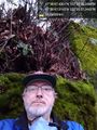
| + | So mid-afternoon turned into late-afternoon, the easy geohash turned out to be on a steep hillside, and the Saloon in question wasn't visible from the geohash. Well, maybe if I climbed the tree. | ||
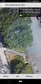
| + | Parked at the saloon in question and crossed the very busy street - rush hour still a thing. Went down the steps and ended up 7m away at one point. Left the path going north to get to 4m - I suspect the actual point was just beyond the tree pictured. | ||
| + | |||
| + | The slope, difficult to tell in the photos, was around 70 degrees, and covered with stickery vines. It snowed last weekend, and everything was very wet. Crossing to the tree risked contusions, slips and falls. I opted to retreat - though climbing the tree to see the Saloon (and thereby earn a pint?) was very tempting. | ||
| + | |||
| + | I also tried from the parking area below, but had a heck of a time getting a signal. | ||
| + | |||
| + | Going for the complete loop, I went on the pedestrian trail under the bridge, then a good half-mile further west before I could work my way back up to Nickerson Street. With a last longing glance at the saloon, I left - though to be honest, had I had a pint, the bridge would have gone up to slow my return home even more. | ||
| + | |||
| + | === Coyotebush === | ||
*test -- [[User:Coyotebush|Coyotebush]] ([[User talk:Coyotebush|talk]]) 21:34, 18 February 2021 (PST) | *test -- [[User:Coyotebush|Coyotebush]] ([[User talk:Coyotebush|talk]]) 21:34, 18 February 2021 (PST) | ||
| + | |||
== Tracklog == | == Tracklog == | ||
<!-- if your GPS device keeps a log, you may post a link here --> | <!-- if your GPS device keeps a log, you may post a link here --> | ||
| Line 60: | Line 65: | ||
<!-- Add any achievement ribbons you earned below, or remove this section --> | <!-- Add any achievement ribbons you earned below, or remove this section --> | ||
| − | |||
| − | |||
| − | |||
| − | |||
| − | |||
| − | |||
| − | |||
| − | |||
| − | |||
| − | |||
| − | |||
| − | |||
| − | |||
| − | |||
[[Category:Expeditions]] | [[Category:Expeditions]] | ||
| − | |||
[[Category:Expeditions with photos]] | [[Category:Expeditions with photos]] | ||
| − | |||
| − | |||
| − | |||
| − | |||
| − | |||
[[Category:Coordinates reached]] | [[Category:Coordinates reached]] | ||
| − | + | {{location|US|WA|KN}} | |
| − | |||
| − | |||
| − | |||
| − | |||
| − | |||
| − | |||
| − | |||
| − | |||
| − | |||
| − | |||
| − | |||
| − | |||
| − | |||
| − | |||
| − | |||
| − | |||
Revision as of 15:58, 19 February 2021
| Thu 18 Feb 2021 in Seattle: 47.6465083, -122.3495135 geohashing.info google osm bing/os kml crox |
Location
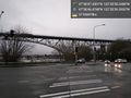
The north edge of Queen Anne, near the Fremont bridge
Participants
Plans
Thomcat - Drop by mid-afternoon, visit the easy geohash, then grab a pint at the Nickerson Street Saloon.
Expedition
Thomcat
So mid-afternoon turned into late-afternoon, the easy geohash turned out to be on a steep hillside, and the Saloon in question wasn't visible from the geohash. Well, maybe if I climbed the tree.
Parked at the saloon in question and crossed the very busy street - rush hour still a thing. Went down the steps and ended up 7m away at one point. Left the path going north to get to 4m - I suspect the actual point was just beyond the tree pictured.
The slope, difficult to tell in the photos, was around 70 degrees, and covered with stickery vines. It snowed last weekend, and everything was very wet. Crossing to the tree risked contusions, slips and falls. I opted to retreat - though climbing the tree to see the Saloon (and thereby earn a pint?) was very tempting.
I also tried from the parking area below, but had a heck of a time getting a signal.
Going for the complete loop, I went on the pedestrian trail under the bridge, then a good half-mile further west before I could work my way back up to Nickerson Street. With a last longing glance at the saloon, I left - though to be honest, had I had a pint, the bridge would have gone up to slow my return home even more.
Coyotebush
- test -- Coyotebush (talk) 21:34, 18 February 2021 (PST)
Tracklog
Photos
Waiting @47.6462,-122.3498
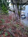
Tree? @47.6464,-122.3495
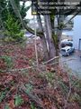
Tree @47.6465,-122.3495
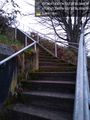
Stairs @47.6465,-122.3495
Geohasher @47.6465,-122.3493
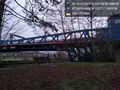
Bridge @47.6474,-122.3505
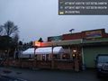
Saloon @47.6466,-122.3500
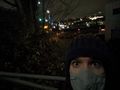
Night geohasher
Map view


