Difference between revisions of "2021-02-19 45 5"
From Geohashing
(Coordinates reached) |
(Add photos) |
||
| Line 17: | Line 17: | ||
== Photos == | == Photos == | ||
<gallery> | <gallery> | ||
| + | Image:2021-02-19 45 5 01.jpg | At Saint-André-le-Gaz train station | ||
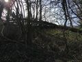
| + | Image:2021-02-19 45 5 08.jpg | Near the geohash | ||
| + | Image:2021-02-19 45 5 02.jpg | No access from here | ||
| + | Image:2021-02-19 45 5 03.jpg | Let's try this way | ||
| + | Image:2021-02-19 45 5 04.png | Coordinates reached | ||
| + | Image:2021-02-19 45 5 05.jpg | Stupid grin | ||
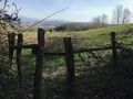
| + | Image:2021-02-19 45 5 06.jpg | Surroundings (south-west) | ||
| + | Image:2021-02-19 45 5 07.jpg | Surroundings (south-east) | ||
</gallery> | </gallery> | ||
| Line 38: | Line 46: | ||
__NOTOC__ | __NOTOC__ | ||
[[Category:Expeditions]] | [[Category:Expeditions]] | ||
| + | [[Category:Expeditions with photos]] | ||
[[Category:Coordinates reached]] | [[Category:Coordinates reached]] | ||
{{location|FR|38}} | {{location|FR|38}} | ||
Revision as of 20:41, 19 February 2021
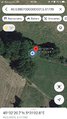
| Fri 19 Feb 2021 in 45,5: 45.5390706, 5.5173906 geohashing.info google osm bing/os kml crox |
Location
In a thicket between two meadows, in Saint-André-le-Gaz.
Participants
Plans
Baarde will take the 13:00 train from Lyon to Saint-André-le-Gaz then walk to the geohash. He expects to be there at 14:10.
Expedition
Photos
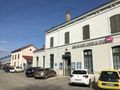
At Saint-André-le-Gaz train station
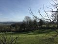
Near the geohash
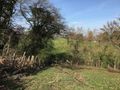
No access from here
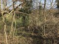
Let's try this way
Coordinates reached

Stupid grin
Surroundings (south-west)
Surroundings (south-east)


Achievements
Baarde earned the Land geohash achievement
|

Baarde earned the Two to the N achievement
by reaching 25 hashpoints on 2021-02-19 45 5 and is promoted to Level 5 (Coordinates reached).