Difference between revisions of "2021-03-02 50 7"
Gefrierbrand (talk | contribs) (An expedition message sent via Geohash Droid for Android.) |
m (Location) |
||
| (6 intermediate revisions by one other user not shown) | |||
| Line 1: | Line 1: | ||
| − | + | {{meetup graticule | |
| − | |||
| − | |||
| − | |||
| − | |||
| − | |||
| − | |||
| − | |||
| − | |||
| lat=50 | | lat=50 | ||
| lon=7 | | lon=7 | ||
| date=2021-03-02 | | date=2021-03-02 | ||
| − | }} | + | }} |
__NOTOC__ | __NOTOC__ | ||
== Location == | == Location == | ||
| − | + | on a field next to a paddock in Sürzerhof. | |
== Participants == | == Participants == | ||
| − | + | [[User:Gefrierbrand|Gefrierbrand]] | |
| − | |||
== Plans == | == Plans == | ||
| − | + | I will try to be there around 1800 | |
== Expedition == | == Expedition == | ||
| − | + | The Hashlocation was very near a road I had to take anyway on my way back home from work. Only a very short detour was needed. I managed to get there a little earlier than anticipated. After parking about 300m away in the small rural village, I walked towards the target and noticed a woman training with her horse in the paddock right next to the field the hash was located on. The aerial pictures had suggested there would be a small path between the fenced property and the field which I intended to use. However, the very narrow turf ribbon was overhung by thorny branches and therefore I had to walk on the field itself. | |
| + | |||
| + | Initially I wanted to stay a bit and explore the area in detail, but I decided against it as I did not want to disturb the horsetraining. I also did not wait until 18:00 since I did not anticipate anybody else showing up. I decided against returning on the shortest path and instead walked along some more (unoccupied, but electrically fenced) horse training areas towards the next regular footpath and then returned to my car. | ||
| − | |||
| − | |||
== Photos == | == Photos == | ||
| Line 34: | Line 25: | ||
--> | --> | ||
<gallery perrow="5"> | <gallery perrow="5"> | ||
| + | |||
| + | Image:2021-03-02_50_7_Gefrierbrand_1615196137927.jpg|Proof | ||
</gallery> | </gallery> | ||
== Achievements == | == Achievements == | ||
{{#vardefine:ribbonwidth|800px}} | {{#vardefine:ribbonwidth|800px}} | ||
| − | + | {{land geohash | |
| − | + | | latitude = 50 | |
| − | + | | longitude = 7 | |
| − | + | | date = 2021-03-02 | |
| − | + | | name = Gefrierbrand | |
| − | + | }} | |
| − | |||
| − | |||
| − | |||
| − | |||
| − | |||
| − | |||
| − | |||
| − | |||
| − | |||
| − | |||
[[Category:Expeditions]] | [[Category:Expeditions]] | ||
| − | |||
| − | |||
| − | |||
| − | |||
| − | |||
| − | |||
| − | |||
[[Category:Coordinates reached]] | [[Category:Coordinates reached]] | ||
| − | + | {{location|DE|RP|MYK}} | |
| − | |||
| − | |||
| − | |||
| − | |||
| − | |||
| − | |||
| − | |||
| − | |||
| − | |||
| − | |||
| − | |||
| − | |||
| − | |||
| − | |||
| − | |||
| − | |||
| − | |||
Latest revision as of 09:42, 8 March 2021
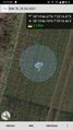
| Tue 2 Mar 2021 in 50,7: 50.3296310, 7.4206861 geohashing.info google osm bing/os kml crox |
Location
on a field next to a paddock in Sürzerhof.
Participants
Plans
I will try to be there around 1800
Expedition
The Hashlocation was very near a road I had to take anyway on my way back home from work. Only a very short detour was needed. I managed to get there a little earlier than anticipated. After parking about 300m away in the small rural village, I walked towards the target and noticed a woman training with her horse in the paddock right next to the field the hash was located on. The aerial pictures had suggested there would be a small path between the fenced property and the field which I intended to use. However, the very narrow turf ribbon was overhung by thorny branches and therefore I had to walk on the field itself.
Initially I wanted to stay a bit and explore the area in detail, but I decided against it as I did not want to disturb the horsetraining. I also did not wait until 18:00 since I did not anticipate anybody else showing up. I decided against returning on the shortest path and instead walked along some more (unoccupied, but electrically fenced) horse training areas towards the next regular footpath and then returned to my car.
Photos
Proof

Achievements
Gefrierbrand earned the Land geohash achievement
|