Difference between revisions of "2021-03-20 42 -83"
(Add location and participants) |
m (Location) |
||
| (15 intermediate revisions by one other user not shown) | |||
| Line 1: | Line 1: | ||
| − | + | [[File:2021-03-20 42 -83 Alison and Corey at hashpoint (Nixill).jpg|thumb|left]] | |
| − | + | {{meetup graticule | |
| − | |||
| − | |||
| − | |||
| − | |||
| − | |||
| − | |||
| − | |||
| lat=42 | | lat=42 | ||
| lon=-83 | | lon=-83 | ||
| date=2021-03-20 | | date=2021-03-20 | ||
| − | }} | + | }} |
__NOTOC__ | __NOTOC__ | ||
== Location == | == Location == | ||
| − | On the Riverwalk in downtown Detroit, Michigan | + | On the Riverwalk in downtown Detroit, Michigan, just south of the southwestern corner of the '''[https://www.tcfcenterdetroit.com/ TCF Center]'''. |
== Participants == | == Participants == | ||
| − | * [[User:Alison|Alison]] | + | * [[User:Alison|Alison]] |
| − | * [[user:MusicalMitten]] | + | * [[user:MusicalMitten|MusicalMitten]] |
| − | * [[user:Nixill]] | + | * [[user:Nixill|Nixill]] |
== Plans == | == Plans == | ||
| − | + | '''Nixill''' (they/them) and '''Alison''''s (she/her) plans started a few hours before the meetup. We planned for our usual weekly grocery pickup and a trip to [https://www.microcenter.com/ Micro Center], a large computer store. After finishing our shopping at Micro Center, we planned on driving down to a transit park and ride lot near the [https://www.amtrak.com/stations/det Detroit Amtrak station] and meeting '''Corey/MusicalMitten''' (he/him) there, then riding bikes to the hashpoint. | |
== Expedition == | == Expedition == | ||
| − | + | Alison picked Nix up for the grocery pickup and Micro Center, then they drove down to the transit park and ride lot, arriving about 16:45. Upon parking, Alison decided to leave her car's sunroof open as it was about 15°C out and sunny and the car has a black roof and black leather interior, and we didn't want to come back to a hot car. | |
| + | |||
| + | At the Amsterdam lot, Nix and Alison met up with Corey, and we all rode our bikes down to the hashpoint. (Corey rode his own; Nix and Alison both rode [https://mogodetroit.org/ MoGo bikeshare] bikes since Alison's car is neither large enough to carry bikes in it nor has a bike rack.) We rode down through [https://detroitmi.gov/departments/parks-recreation/parks/hart-plaza Hart Plaza] to reach the Riverwalk, then west along the Riverwalk to the hashpoint. We arrived at the hashpoint about 17:30. | ||
| + | |||
| + | When we reached the hashpoint, we stopped to take some photos, hang out for a bit, and admire the Windsor skyline across the river. We also discussed what we wanted to do afterward, and decided on riding our bikes east along Atwater Street to [https://detroitmi.gov/departments/parks-recreation/belle-isle Belle Isle], a state park on an island in the Detroit River. | ||
| + | |||
| + | We proceeded on this plan, stopping at a few MoGo stations on the way to replenish our timers. (Nix and Alison both have MoGo passes, which allow unlimited 1-hour rides before getting charged overage fees. Putting a MoGo bike back in the dock and then immediately removing it again counts as a separate ride.) Alison swapped her non-electric MoGo bike visible in the hashpoint photo for a MoGo Boost e-bike. We were delayed at the Belle Isle bridge by several car drivers who didn't understand the concept of a yield sign and the fact that it applies to bikes in the bike lane that crosses the slip road, but ended up arriving at the island safely. | ||
| + | |||
| + | We nearly circumnavigated Belle Isle, stopping at the "Bus Stop Comfort Station No. 7" (at which no buses currently stop) to use the restrooms and attempt unsuccessfully to use a vending machine that was turned off. We saw a photographer with a telephoto lens shooting a bald eagle perched on a tree in an island (unnamed) in a lake (Lake Okonoka) in the island (Belle Isle) on the river (Detroit River). Rounding the eastern tip of the island, we started feeling a bit chilly because the wind was picking up and the sun was getting lower in the sky. Also, our MoGo time was running short because there are no docks on the island. We booked it off the island and to the nearest MoGo station (in the West Village neighbourhood), where we docked the bikes and decided on a curbside order at the McDonald's about five blocks to the east for dinner. | ||
| + | |||
| + | Here's where things really went wrong. When we arrived at the McDonald's (again, Corey on his own bike and Nix and I on MoGos Boost), we discovered that there were no labelled curbside parking spaces, nor would the mobile app let us check in for curbside pickup, nor was the lobby open for counter service. We asked another McDonald's employee what to do while they were serving another customer by curbside, and they directed one of us through the drive-through lanes. By this time, it was about 19:30 and the <s>sun has gone down and the moon has come up, and long ago somebody left with the cup</s> sun was setting and it was getting yet colder. Also, the drive-through line was wrapped all the way around the building and out onto Jefferson Avenue. | ||
| + | |||
| + | We finally got our food a bit around 20:05. So much for "fast food". By this time, we didn't have enough time to eat in the McDonald's parking lot, so we schlepped the food back to the MoGo dock, docked the bikes, and eat there. Nix's Filet-O-Fish had tartar sauce on it, despite that they ordered it with mayo instead. | ||
| + | |||
| + | We finished eating around 20:25 and decided that we were underdressed for how cold it had become, and that we needed to ride the bus back to where our cars were parked. The nearest bus stop was at Jefferson and Van Dyke, about three long blocks away from the MoGo Station. We ran there and arrived just in time for an inbound bus. Even though fare collection was officially resumed on 15 March, the driver waved us on without making us pay fare. Corey spilled the McDonald's drinks on himself and the bus seat. We alighted at Spirit Plaza at 20:50, about ten minutes before a northbound Woodward bus was due at Congress Street on the other side of the plaza. | ||
| + | |||
| + | The Woodward bus picked us up on schedule and the driver let us on fare-free again. Several bus passengers were wearing their masks as chin straps. This was still our best transportation option given where we were, where we needed to be, and what we were wearing, though. We alighted the Woodward bus at Piquette Avenue around 21:20, crossed the street to the parking lot our cars were in, bid one another farewell, then Alison drove Nix home and Corey drove himself home. | ||
== Tracklog == | == Tracklog == | ||
| − | + | * [[File:2021-03-20 42 -83 pre-hash tracklog.gpx]] | |
| + | * [[File:2021-03-20 42 -83 post-hash tracklog.gpx]] | ||
| + | * [[User:Alison|Alison]]'s déjà vu proof: [[File:2021-03-20 42 -83 Alison deja vu proof.gpx]] | ||
== Photos == | == Photos == | ||
| − | |||
| − | |||
| − | |||
<gallery perrow="5"> | <gallery perrow="5"> | ||
| + | File:2021-03-20 42 -83 cars in park and ride (Alison).jpg | Corey's and Alison's cars in the park and ride lot, obeying social distancing rules. | ||
| + | File:2021-03-20 42 -83 Alison and Corey at hashpoint (Nixill).jpg | Alison and Corey at the hashpoint with everyone's bikes. Nix took the photo because they didn't want to be in it. | ||
| + | File:2021-03-20 42 -83 proof screenshot (Alison).png | Proof screenshot from Alison's phone, showing GPS coordinates. | ||
| + | File:2021-03-20 42 -83 Atwater under TCF Center (Alison).jpg | Atwater Street under the TCF Center. | ||
| + | File:2021-03-20 42 -83 Windsor panorama (Alison).jpg | The Windsor skyline, featuring Nix's arm because they were pointing out the Windsor International Transit Terminal to Corey. | ||
| + | File:2021-03-20 42 -83 Corey at Station 7 (Nix).jpg | Corey and his bike at Station 7 on Belle Isle. | ||
| + | File:2021-03-20 42 -83 island (Nix).jpg | The island, on which is the tree, on which is the bald eagle. | ||
| + | File:2021-03-20 42 -83 bald eagle (Nix).jpg | Nix's attempt at a bald eagle telephoto shot. | ||
| + | File:2021-03-20 42 -83 bald eagle (Corey).jpg | Corey's attempt at a bald eagle telephoto shot. | ||
| + | File:2021-03-20 42 -83 bald eagle (Alison).jpg | Alison's attempt at a bald eagle telephoto shot. We all only brought our smartphones. | ||
| + | File:2021-03-20 42 -83 McDs queue (Alison).jpg | The queue at McDonald's. At this point, it was 19:48 and Nix was only halfway through the queue. | ||
| + | File:2021-03-20 42 -83 sunset at McDs (Alison).jpg | Looking west from McDonalds at the setting sun. | ||
| + | File:2021-03-20 42 -83 Jeffersonian Houze (Alison).jpg | Jeffersonian Houze, a high-rise apartment building across Jefferson Avenue from McDonald's. | ||
| + | File:2021-03-20 42 -83 MoGo dock (Alison).jpg | The MoGo dock at Agnes and Parker, whence we left for the bus stop because it was cold. | ||
| + | File:2021-03-20 42 -83 Spirit of Detroit (Corey).jpg | The Spirit of Detroit statue, overlooking Spirit Plaza. | ||
| + | File:2021-03-20 42 -83 Bike on bus (Corey).jpg | Corey's bike on the rack of the Woodward bus. | ||
</gallery> | </gallery> | ||
== Achievements == | == Achievements == | ||
{{#vardefine:ribbonwidth|800px}} | {{#vardefine:ribbonwidth|800px}} | ||
| − | + | {{Déjà vu geohash | |
| + | | latitude = 42 | ||
| + | | longitude = -83 | ||
| + | | date = 2021-03-20 | ||
| + | | olddate = 2020-09-20 | ||
| + | | name = [[User:Alison|Alison]] | ||
| + | }} | ||
| + | {{Déjà vu geohash | ||
| + | | latitude = 42 | ||
| + | | longitude = -83 | ||
| + | | date = 2021-03-20 | ||
| + | | olddate = 2021-03-17 | ||
| + | | name = [[User:MusicalMitten|MusicalMitten]] | ||
| + | }} | ||
| + | {{Radio Yerevan | ||
| + | | achievement = [[Drowned Rat Geohash]] | ||
| + | | detail = he spilled drinks on himself in the return trip, and not on the way there | ||
| + | | date = 2021-03-20 | ||
| + | | latitude = 42 | ||
| + | | longitude = -83 | ||
| + | | user = [[User:MusicalMitten|MusicalMitten]] | ||
| + | }} | ||
| − | |||
| − | |||
| − | |||
| − | |||
| − | |||
| − | |||
| − | |||
| − | |||
| − | |||
| − | |||
| − | |||
| − | |||
| − | |||
| − | |||
[[Category:Expeditions]] | [[Category:Expeditions]] | ||
| − | |||
[[Category:Expeditions with photos]] | [[Category:Expeditions with photos]] | ||
| − | |||
| − | |||
| − | |||
| − | |||
| − | |||
[[Category:Coordinates reached]] | [[Category:Coordinates reached]] | ||
| − | + | {{location|US|MI|WY}} | |
| − | |||
| − | |||
| − | |||
| − | |||
| − | |||
| − | |||
| − | |||
| − | |||
| − | |||
| − | |||
| − | |||
| − | |||
| − | |||
| − | |||
| − | |||
| − | |||
| − | |||
Latest revision as of 02:42, 25 March 2021
.jpg)
| Sat 20 Mar 2021 in 42,-83: 42.3247914, -83.0493433 geohashing.info google osm bing/os kml crox |
Location
On the Riverwalk in downtown Detroit, Michigan, just south of the southwestern corner of the TCF Center.
Participants
Plans
Nixill (they/them) and Alison's (she/her) plans started a few hours before the meetup. We planned for our usual weekly grocery pickup and a trip to Micro Center, a large computer store. After finishing our shopping at Micro Center, we planned on driving down to a transit park and ride lot near the Detroit Amtrak station and meeting Corey/MusicalMitten (he/him) there, then riding bikes to the hashpoint.
Expedition
Alison picked Nix up for the grocery pickup and Micro Center, then they drove down to the transit park and ride lot, arriving about 16:45. Upon parking, Alison decided to leave her car's sunroof open as it was about 15°C out and sunny and the car has a black roof and black leather interior, and we didn't want to come back to a hot car.
At the Amsterdam lot, Nix and Alison met up with Corey, and we all rode our bikes down to the hashpoint. (Corey rode his own; Nix and Alison both rode MoGo bikeshare bikes since Alison's car is neither large enough to carry bikes in it nor has a bike rack.) We rode down through Hart Plaza to reach the Riverwalk, then west along the Riverwalk to the hashpoint. We arrived at the hashpoint about 17:30.
When we reached the hashpoint, we stopped to take some photos, hang out for a bit, and admire the Windsor skyline across the river. We also discussed what we wanted to do afterward, and decided on riding our bikes east along Atwater Street to Belle Isle, a state park on an island in the Detroit River.
We proceeded on this plan, stopping at a few MoGo stations on the way to replenish our timers. (Nix and Alison both have MoGo passes, which allow unlimited 1-hour rides before getting charged overage fees. Putting a MoGo bike back in the dock and then immediately removing it again counts as a separate ride.) Alison swapped her non-electric MoGo bike visible in the hashpoint photo for a MoGo Boost e-bike. We were delayed at the Belle Isle bridge by several car drivers who didn't understand the concept of a yield sign and the fact that it applies to bikes in the bike lane that crosses the slip road, but ended up arriving at the island safely.
We nearly circumnavigated Belle Isle, stopping at the "Bus Stop Comfort Station No. 7" (at which no buses currently stop) to use the restrooms and attempt unsuccessfully to use a vending machine that was turned off. We saw a photographer with a telephoto lens shooting a bald eagle perched on a tree in an island (unnamed) in a lake (Lake Okonoka) in the island (Belle Isle) on the river (Detroit River). Rounding the eastern tip of the island, we started feeling a bit chilly because the wind was picking up and the sun was getting lower in the sky. Also, our MoGo time was running short because there are no docks on the island. We booked it off the island and to the nearest MoGo station (in the West Village neighbourhood), where we docked the bikes and decided on a curbside order at the McDonald's about five blocks to the east for dinner.
Here's where things really went wrong. When we arrived at the McDonald's (again, Corey on his own bike and Nix and I on MoGos Boost), we discovered that there were no labelled curbside parking spaces, nor would the mobile app let us check in for curbside pickup, nor was the lobby open for counter service. We asked another McDonald's employee what to do while they were serving another customer by curbside, and they directed one of us through the drive-through lanes. By this time, it was about 19:30 and the sun has gone down and the moon has come up, and long ago somebody left with the cup sun was setting and it was getting yet colder. Also, the drive-through line was wrapped all the way around the building and out onto Jefferson Avenue.
We finally got our food a bit around 20:05. So much for "fast food". By this time, we didn't have enough time to eat in the McDonald's parking lot, so we schlepped the food back to the MoGo dock, docked the bikes, and eat there. Nix's Filet-O-Fish had tartar sauce on it, despite that they ordered it with mayo instead.
We finished eating around 20:25 and decided that we were underdressed for how cold it had become, and that we needed to ride the bus back to where our cars were parked. The nearest bus stop was at Jefferson and Van Dyke, about three long blocks away from the MoGo Station. We ran there and arrived just in time for an inbound bus. Even though fare collection was officially resumed on 15 March, the driver waved us on without making us pay fare. Corey spilled the McDonald's drinks on himself and the bus seat. We alighted at Spirit Plaza at 20:50, about ten minutes before a northbound Woodward bus was due at Congress Street on the other side of the plaza.
The Woodward bus picked us up on schedule and the driver let us on fare-free again. Several bus passengers were wearing their masks as chin straps. This was still our best transportation option given where we were, where we needed to be, and what we were wearing, though. We alighted the Woodward bus at Piquette Avenue around 21:20, crossed the street to the parking lot our cars were in, bid one another farewell, then Alison drove Nix home and Corey drove himself home.
Tracklog
- File:2021-03-20 42 -83 pre-hash tracklog.gpx
- File:2021-03-20 42 -83 post-hash tracklog.gpx
- Alison's déjà vu proof: File:2021-03-20 42 -83 Alison deja vu proof.gpx
Photos
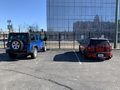
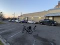
Corey's and Alison's cars in the park and ride lot, obeying social distancing rules.
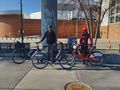
Alison and Corey at the hashpoint with everyone's bikes. Nix took the photo because they didn't want to be in it.
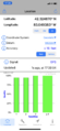
Proof screenshot from Alison's phone, showing GPS coordinates.
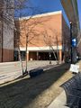
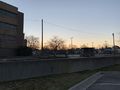
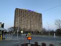
Atwater Street under the TCF Center.
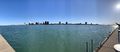
The Windsor skyline, featuring Nix's arm because they were pointing out the Windsor International Transit Terminal to Corey.
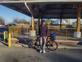
Corey and his bike at Station 7 on Belle Isle.
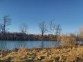
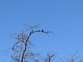
The island, on which is the tree, on which is the bald eagle.
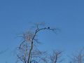
Nix's attempt at a bald eagle telephoto shot.
Corey's attempt at a bald eagle telephoto shot.
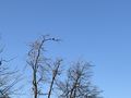
Alison's attempt at a bald eagle telephoto shot. We all only brought our smartphones.
The queue at McDonald's. At this point, it was 19:48 and Nix was only halfway through the queue.
Looking west from McDonalds at the setting sun.
Jeffersonian Houze, a high-rise apartment building across Jefferson Avenue from McDonald's.
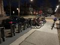
The MoGo dock at Agnes and Parker, whence we left for the bus stop because it was cold.
The Spirit of Detroit statue, overlooking Spirit Plaza.
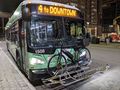
Corey's bike on the rack of the Woodward bus.
.jpg)
.png)
.jpg)
.jpg)
.jpg)
.jpg)
.jpg)
.jpg)
.jpg)
.jpg)
.jpg)
.jpg)
.jpg)
.jpg)
.jpg)
Achievements
Alison earned the Déjà Vu Geohash Achievement
|
MusicalMitten earned the Déjà Vu Geohash Achievement
|
Is it true that MusicalMitten earned the Drowned Rat Geohash?
|