Difference between revisions of "2021-03-22 53 9"
m (clearing up username confusion) |
(→Photos) |
||
| Line 11: | Line 11: | ||
==Photos== | ==Photos== | ||
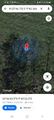
| − | + | [[File:2021-03-22 53 9 2.jpg|750px|Panorama at the geohash]] | |
| − | <gallery | + | <gallery> |
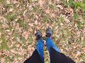
| + | File:2021-03-22 53 9 c.jpg | coords | ||
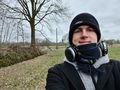
| + | File:2021-03-22 53 9 p.jpg | proof | ||
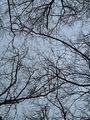
| + | File:2021-03-22 53 9 1.jpg | π π π | ||
| + | File:2021-03-22 53 9 3.jpg | the hash | ||
| + | File:2021-03-22 53 9 4.jpg | must sound funny to non-Germans … | ||
| + | File:2021-03-22 53 9 5.jpg | this one's for John Green | ||
</gallery> | </gallery> | ||
Latest revision as of 20:01, 3 March 2023
| Mon 22 Mar 2021 in 53,9: 53.7788623, 9.6727608 geohashing.info google osm bing/os kml crox |
Location
on a meadow next to a forest in Klein Offenseth-Sparrieshoop, Schleswig-Holstein
Participants
Expedition
Went for this because it was another ~2-hour expedition. Because I had 40 minutes in Klein Offenseth-Sparrieshoop (North German place names, man), I decided to walk from the station to the hash instead of cycling. I took the A3 train and had to spend 15 minutes at Barmstedt station, then walked a residential street along the railway tracks for 1.1 km after getting off, eating cookies on the way. The hash lay at the edge of a meadow just 28 m from the road, 37 m from the railway and around 10 m from a forest. The location was easy to find, I quickly took pictures and then walked off the field through the open gate. Because I had a few minutes to spare, I went into the forest for a while. Then I walked back to station, arriving just in time for my train, and rode it back home for 25 minutes.
Photos


coords
proof
π π π
the hash
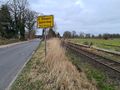
must sound funny to non-Germans …
this one's for John Green


Achievements
Land geohash, Public transport geohash