Difference between revisions of "2021-03-28 47 -122"
([live picture]Water [https://openstreetmap.org/?lat=47.79035130&lon=-122.14145440&zoom=16&layers=B000FTF @47.7904,-122.1415]) |
(success last Sunday) |
||
| Line 1: | Line 1: | ||
| − | + | {{meetup graticule | |
| − | |||
| − | |||
| − | |||
| − | |||
| − | |||
| − | |||
| − | |||
| − | |||
| lat=47 | | lat=47 | ||
| lon=-122 | | lon=-122 | ||
| date=2021-03-28 | | date=2021-03-28 | ||
| − | }} | + | | graticule_name=Seattle |
| + | | graticule_link=Seattle, Washington | ||
| + | }} | ||
__NOTOC__ | __NOTOC__ | ||
== Location == | == Location == | ||
| − | + | On the grounds of the [https://www.kingcounty.gov/depts/dnrp/wtd/system/brightwater.aspx Brightwater] treatment plant | |
== Participants == | == Participants == | ||
| − | + | * [[User:Thomcat|Thomcat]] | |
| − | |||
== Plans == | == Plans == | ||
| − | + | Stop by after work? | |
== Expedition == | == Expedition == | ||
| − | + | First baseball game of the year was south of this, in Belleveue. It was also rained out. After hustling over the toll bridge to get there, I decided to take a more leisurely return journey and see just how accessible this hashpoint is. | |
| + | |||
| + | The good news - very accessible! The bad news - the rain followed me north, turning into hail at the end. | ||
| + | |||
| + | The [https://www.kingcounty.gov/services/environment/brightwater-center.aspx trail system] here is pretty good. I was able to park, walk past the interesting visitors building, over a few pedestrian bridges and then on to the hashpoint. My original thought was to explore the park more, but impending darkness and hail changed my mind a bit. | ||
| + | |||
| + | Reading more about the [https://www.kingcounty.gov/depts/dnrp/wtd/system/brightwater.aspx facility] is an exercise for the student, but realize it is at the head of a 13 mile (21 km) long tunnel leading west to Puget Sound. Here the clean and treated water is dumped directly into the Sound, with the outflow some 600 feet below the surface. | ||
== Tracklog == | == Tracklog == | ||
| − | |||
== Photos == | == Photos == | ||
| Line 48: | Line 46: | ||
== Achievements == | == Achievements == | ||
{{#vardefine:ribbonwidth|800px}} | {{#vardefine:ribbonwidth|800px}} | ||
| − | |||
| − | |||
| − | |||
| − | |||
| − | |||
| − | |||
| − | |||
| − | |||
| − | |||
| − | |||
| − | |||
| − | |||
| − | |||
| − | |||
| − | |||
[[Category:Expeditions]] | [[Category:Expeditions]] | ||
| − | |||
[[Category:Expeditions with photos]] | [[Category:Expeditions with photos]] | ||
| − | |||
| − | |||
| − | |||
| − | |||
| − | |||
[[Category:Coordinates reached]] | [[Category:Coordinates reached]] | ||
| − | + | {{location|US|WA|KN}} | |
| − | |||
| − | |||
| − | |||
| − | |||
| − | |||
| − | |||
| − | |||
| − | |||
| − | |||
| − | |||
| − | |||
| − | |||
| − | |||
| − | |||
| − | |||
| − | |||
| − | |||
Revision as of 15:44, 31 March 2021
| Sun 28 Mar 2021 in Seattle: 47.7962037, -122.1414554 geohashing.info google osm bing/os kml crox |
Location
On the grounds of the Brightwater treatment plant
Participants
Plans
Stop by after work?
Expedition
First baseball game of the year was south of this, in Belleveue. It was also rained out. After hustling over the toll bridge to get there, I decided to take a more leisurely return journey and see just how accessible this hashpoint is.
The good news - very accessible! The bad news - the rain followed me north, turning into hail at the end.
The trail system here is pretty good. I was able to park, walk past the interesting visitors building, over a few pedestrian bridges and then on to the hashpoint. My original thought was to explore the park more, but impending darkness and hail changed my mind a bit.
Reading more about the facility is an exercise for the student, but realize it is at the head of a 13 mile (21 km) long tunnel leading west to Puget Sound. Here the clean and treated water is dumped directly into the Sound, with the outflow some 600 feet below the surface.
Tracklog
Photos
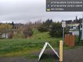
Parked @47.7918,-122.1420
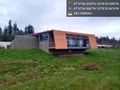
Brightwater @47.7935,-122.1419
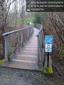
Bridges & wetlands @47.7949,-122.1416
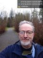
Geohasher @47.7962,-122.1415
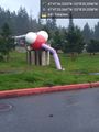
Water @47.7904,-122.1415


