2021-03-31 48 7
From Geohashing
| Wed 31 Mar 2021 in 48,7: 48.2978890, 7.4449001 geohashing.info google osm bing/os kml crox |
Location
In an orchard a meadow near Scherwiller.
Participants
Plans
Baarde is going to take his bicycle and ride there in the afternoon. He expects to reach the hashpoint around 15:00.
Expedition
[Missing introduction]
According to satellite imagery, the geohash was supposed to be located in the middle of an orchard. However, the place was completely tree-less.
After recording proof, I turned westwards and made a 20 km loop through the Vosges mountains before stopping on a small hill below the ruins of the Ramstein and Ortenbourg castles.
[Missing conclusion]
Photos
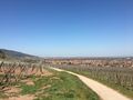
Cycling through the vineyards
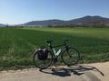
Where's the orchard?
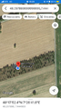
Coordinates reached
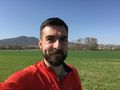
Stupid grin
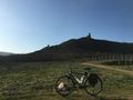
The Ramstein and Ortenbourg castles
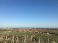
Scherwiller
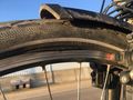
That's not supposed to happen


Achievements
Baarde earned the Land geohash achievement
|
Baarde earned the Bicycle geohash achievement
|