Difference between revisions of "2021-04-21 52 10"
From Geohashing
m (Location correction) |
m |
||
| Line 32: | Line 32: | ||
==Achievements== | ==Achievements== | ||
{{#vardefine:ribbonwidth|100%}} | {{#vardefine:ribbonwidth|100%}} | ||
| − | {{land geohash|date=2021-04-21|latitude=52|longitude=10|name=[[User:Fippe|Fippe]]|image=2021-04-21 52 10 | + | {{land geohash|date=2021-04-21|latitude=52|longitude=10|name=[[User:Fippe|Fippe]]|image=2021-04-21 52 10 03 Geohash.jpg}} |
__NOTOC__ | __NOTOC__ | ||
Revision as of 19:49, 21 April 2021
| Wed 21 Apr 2021 in Braunschweig: 52.0201630, 10.1435142 geohashing.info google osm bing/os kml crox |
Location
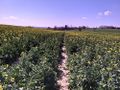
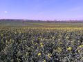
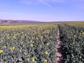
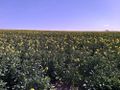
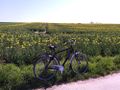
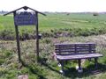
This Geohash is located on a canola field in Volkersheim.
Participants
Expedition
I took the train to Derneburg and rode the bike for the rest of the distance. There were some hills, but I overcame them. The field turned out to be full of canola plants, but I was able to reach the Geohash in one of the tractor tracks and recorded proof. Afterwards, I rode back to Derneburg and went to see the 19th-century pyramid some count had built as a grave for his family, and took the train back home after that.
Photos
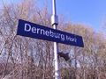
In Derneburg
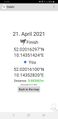
Proof
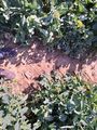
The Geohash
Surroundings
Surroundings
Surroundings
Surroundings
The site of the Geohash
Near Volkersheim
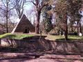
The pyramid in Derneburg


Achievements
Fippe earned the Land geohash achievement
|