Difference between revisions of "2021-05-08 41 -71"
From Geohashing
m (Location) |
|||
| Line 19: | Line 19: | ||
<gallery perrow="5"> | <gallery perrow="5"> | ||
| − | + | Image:08-05-2021 41 -71 Dirt Road.jpg|thumb|It's funny how often geohashing will lead you onto a one-lane dirt road. | |
| + | Image:08-05-2021 41 -71 Field.jpg|thumb|Tamari must have used that jutsu that cuts down every tree around. | ||
| + | Image:08-05-2021 41 -71 The Spot.jpg|thumb|The actual geohash was somewhere in this indistinguishable little section. | ||
| + | Image:08-05-2021 41 -71 GPS.png|thumb|Once again, Google Maps wasn't as precise as could be, but it sufficed. | ||
| + | Image:08-05-2021 41 -71 Compass.png|thumb|Just a little more proof, Greene is a village within the town of Coventry. | ||
</gallery> | </gallery> | ||
Revision as of 02:08, 9 May 2021
| Sat 8 May 2021 in 41,-71: 41.6806358, -71.7828062 geohashing.info google osm bing/os kml crox |
Location
In a field of fallen trees off a dirt road in Coventry, Rhode Island.
Participants
Expedition
I'll tell my tale, I swear, just give me a little bit.
Photos
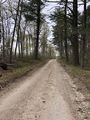
It's funny how often geohashing will lead you onto a one-lane dirt road.
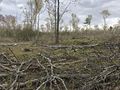
Tamari must have used that jutsu that cuts down every tree around.
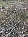
The actual geohash was somewhere in this indistinguishable little section.
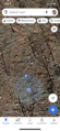
Once again, Google Maps wasn't as precise as could be, but it sufficed.

Just a little more proof, Greene is a village within the town of Coventry.


Achievements
This user earned the Land geohash achievement
|