Difference between revisions of "2021-05-08 41 -71"
| (3 intermediate revisions by 2 users not shown) | |||
| Line 14: | Line 14: | ||
== Expedition == | == Expedition == | ||
| − | I' | + | After not making any geohash attempts in April, I figured the best way to get back on the scene was with a bang. On a drive from the suburbs of Boston back home to New York, I would make my first attempts outside of my home graticule of 41 -73, and beyond that, I would go for a multihash. When scouting out the locations beforehand, I figured that this one should be doable as long as there weren't any unavoidable markers of private property. |
| + | |||
| + | My drive from Mansfield, MA took me through a part of Rhode Island I would have absolutely no reason to visit again, but that's not to say it wasn't nice. I got especially excited when my route took me onto a dirt road, a sure sign that you're getting into something good. After a couple miles, I pulled off the side of this path through the woods and made my way into a field completely filled with fallen trees. There were plenty of stumps that showed they had been cut, but why leave so many trees where they were? I guess that lumber just wasn't big enough for their purposes? I could have asked the owner of the property, whose house was just down the road, but it was probably best to just slip in and out undetected. Exactly the way I normally do ;) (with consent, of course, you get what I'm saying). | ||
| + | |||
| + | It was such a peaceful area, there was no noise from any nearby roads and the sporadic chirping of birds didn't offset how nicely quiet it all was. It took a little bit on wandering up and over the countless fallen trees to get to what my phone told me was the spot, but eventually I felt reasonably confident that I had found it. Of course, it was just another pile of branches, nothing special to mark it. Just like that, my very first out-of-state geohash was complete, and I wasn't even close to finished for the day. Check out the other two attempts I made that day [[2021-05-08 41 -72|here]] and [[2021-05-08 41 -73|here]]. | ||
== Photos == | == Photos == | ||
<gallery perrow="5"> | <gallery perrow="5"> | ||
| − | + | Image:08-05-2021 41 -71 Dirt Road.jpg|thumb|It's funny how often geohashing will lead you onto a one-lane dirt road. | |
| + | Image:08-05-2021 41 -71 Field.jpg|thumb|Tamari must have used that jutsu that cuts down every tree around. | ||
| + | Image:08-05-2021 41 -71 The Spot.jpg|thumb|The actual geohash was somewhere in this indistinguishable little section. | ||
| + | Image:08-05-2021 41 -71 GPS.png|thumb|Once again, Google Maps wasn't as precise as could be, but it sufficed. | ||
| + | Image:08-05-2021 41 -71 Compass.png|thumb|Just a little more proof, Greene is a village within the town of Coventry. | ||
</gallery> | </gallery> | ||
| Line 32: | Line 40: | ||
[[Category:Expeditions]] | [[Category:Expeditions]] | ||
[[Category:Coordinates reached]] | [[Category:Coordinates reached]] | ||
| + | {{location|US|RI|KE}} | ||
Latest revision as of 18:52, 9 May 2021
| Sat 8 May 2021 in 41,-71: 41.6806358, -71.7828062 geohashing.info google osm bing/os kml crox |
Location
In a field of fallen trees off a dirt road in Coventry, Rhode Island.
Participants
Expedition
After not making any geohash attempts in April, I figured the best way to get back on the scene was with a bang. On a drive from the suburbs of Boston back home to New York, I would make my first attempts outside of my home graticule of 41 -73, and beyond that, I would go for a multihash. When scouting out the locations beforehand, I figured that this one should be doable as long as there weren't any unavoidable markers of private property.
My drive from Mansfield, MA took me through a part of Rhode Island I would have absolutely no reason to visit again, but that's not to say it wasn't nice. I got especially excited when my route took me onto a dirt road, a sure sign that you're getting into something good. After a couple miles, I pulled off the side of this path through the woods and made my way into a field completely filled with fallen trees. There were plenty of stumps that showed they had been cut, but why leave so many trees where they were? I guess that lumber just wasn't big enough for their purposes? I could have asked the owner of the property, whose house was just down the road, but it was probably best to just slip in and out undetected. Exactly the way I normally do ;) (with consent, of course, you get what I'm saying).
It was such a peaceful area, there was no noise from any nearby roads and the sporadic chirping of birds didn't offset how nicely quiet it all was. It took a little bit on wandering up and over the countless fallen trees to get to what my phone told me was the spot, but eventually I felt reasonably confident that I had found it. Of course, it was just another pile of branches, nothing special to mark it. Just like that, my very first out-of-state geohash was complete, and I wasn't even close to finished for the day. Check out the other two attempts I made that day here and here.
Photos
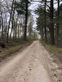
It's funny how often geohashing will lead you onto a one-lane dirt road.
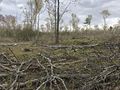
Tamari must have used that jutsu that cuts down every tree around.
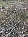
The actual geohash was somewhere in this indistinguishable little section.
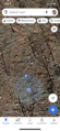
Once again, Google Maps wasn't as precise as could be, but it sufficed.

Just a little more proof, Greene is a village within the town of Coventry.


Achievements
This user earned the Land geohash achievement
|