Difference between revisions of "2021-05-10 51 9"
From Geohashing
(New report) |
m (Adding hours) |
||
| (One intermediate revision by the same user not shown) | |||
| Line 37: | Line 37: | ||
[[Category:Expeditions with photos]] | [[Category:Expeditions with photos]] | ||
{{location|DE|NI|HI}} | {{location|DE|NI|HI}} | ||
| − | + | {{user categories|user=Fippe|bike=10|train=135|foot=13|hours=12}} | |
Latest revision as of 19:39, 11 December 2022
| Mon 10 May 2021 in Kassel: 51.9056046, 9.9678417 geohashing.info google osm bing/os kml crox |
Location
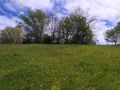
This Geohash is located on a meadow in Wetteborn.
Participants
Expedition
I took the train to Freden and walked the rest of the way. Trusting Google Maps, I took a path through a forest which might not actually have been a path. In Wetteborn I reached the coordinates, they were on a meadow on a hill with a nice view. After recording proof I went back to Freden, but this time not through the forest. From Freden, I took the train back to Hannover.
Photos
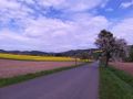
Looking back at Freden
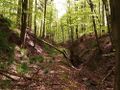
This is a path in the forest. Or is it?

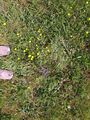
Proof
The Geohash
Surroundings
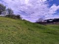
Surroundings
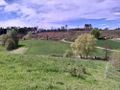
Surroundings
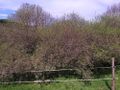
Surroundings


Achievements
Fippe earned the Land geohash achievement
|