Difference between revisions of "2021-05-20 50 7"
Gefrierbrand (talk | contribs) |
Gefrierbrand (talk | contribs) |
||
| (9 intermediate revisions by 2 users not shown) | |||
| Line 6: | Line 6: | ||
__NOTOC__ | __NOTOC__ | ||
== Location == | == Location == | ||
| − | In a | + | In a barley field near Filsen |
== Participants == | == Participants == | ||
| Line 14: | Line 14: | ||
== Expedition == | == Expedition == | ||
| − | + | And another fun one! After work we decided to go Geohashing again. The map-survey showed a ferry crossing the Rhine river near the hashlocation and we decided to take a very narrow road to get there and use said ferry to cross the river and walk onwards from there. | |
| + | |||
| + | The narrow road turned out to be also very steep and curvy, but fun to drive along. It had also a small parkinglot in the middle and a bench with a great view on "mill valley". We continued towards Boppard and parked in line for the ferry crossing, which was loading passengers on the other side. Looking at the timetables we noticed that we had some time left to kill and quickly wandered though a few parks along the shore before returning to the car. | ||
| + | |||
| + | Then suddenly a police boat arrived very quickly, turned around and moored alongside the ferry. Some policemen climbed around and everybody on our side (which was surprisingly 200 m away) started wondering what's going on. First, we couldn't really make out what they were doing, but they started to fiddle around with long sticks and ropes at the front of the ferry. | ||
| + | |||
| + | Gefrierbrand then couldn't cope any longer with not-knowing what's going on and took his binoculars from the trunk to have a better look, even if it was slightly creepy. Using them, we could see that the ferry got somewhat entangled with a large tree branch and was possibly stuck. | ||
| + | |||
| + | Since our crossing was the last scheduled one for the day we worried a bit if we have to find alternate routes, but luckily the police was able to free the ferry from the wood by driving around with their boat and creating large waves on the water. | ||
| + | |||
| + | After crossing the Rhine, we drove to Filsen and continued on foot up a hill trough a forest towards the hash. We noticed quite a lot of high seats used for hunting, and one of them had a very interesting constriction which made it look like it was one-legged. | ||
| + | |||
| + | Finding the hash was relatively easy, even though we both had bad GPS reception during the entire expedition. Santu identified the grain as barley and we were able to carefully wade into the field to the location. The plants were already grown to a height were Pedro completely disappeared in them. We had some fun by hiding and letting him jump around and then took another way back towards the car. | ||
| + | |||
| + | This route let us to even more nice vantage points with great views on the Rhine and Boppard, and it had lots of information boards explaining local animals, plants and terrain. | ||
| + | |||
| + | On our way back home we had no GPS reception at all and it took a while to get out of Filsen with a few wrong turns, but we eventually managed it and even drove through some nice alleys and a crooked house. | ||
== Photos == | == Photos == | ||
| − | |||
| − | |||
| − | |||
<gallery perrow="5"> | <gallery perrow="5"> | ||
| + | File:2021-05-20_50_7 slopy way.jpg | Slopy route along the way | ||
| + | File:2021-05-20_50_7 grin on the way.jpg | Stupid grin on slopy road | ||
| + | File:2021-05-20_50_7 stuck ferry.jpg | stuck ferry | ||
| + | File:2021-05-20_50_7 police boat.jpg | Police boat in front of ferry | ||
| + | File:2021-05-20_50_7 high seat.jpg | interesting high seat | ||
| + | File:2021-05-20_50_7 santu at hash.jpg | Santu smiling at hash | ||
| + | File:2021-05-20_50_7 stupid grin.jpg | StupidGrin<sup>TM<sup> | ||
| + | File:2021-05-20_50_7 view on boppard.jpg | nice view on Boppard | ||
| + | File:2021-05-20_50_7 cherries.jpg | giant cherries | ||
| + | File:2021-05-20_50_7 crooked house.jpg | very crooked house | ||
| + | File:2021-05-20_50_7 pedro in field.jpg | Pedro running through barley | ||
| + | File:2021-05-20_50_7 pedro in field.mp4 | just barely visible Pedro being fed | ||
| + | File:2021-05-20_50_7 proof.jpg | Proof | ||
</gallery> | </gallery> | ||
| Line 26: | Line 52: | ||
{{#vardefine:ribbonwidth|800px}} | {{#vardefine:ribbonwidth|800px}} | ||
<!-- Add any achievement ribbons you earned below, or remove this section --> | <!-- Add any achievement ribbons you earned below, or remove this section --> | ||
| + | {{land geohash | ||
| + | | latitude = 50 | ||
| + | | longitude = 7 | ||
| + | | date = 2021-05-20 | ||
| + | | name = [[User:Gefrierbrand|Gefrierbrand]] and [[User:Santu|Santu]] | ||
| + | }} | ||
| + | {{gratuitous ribbon | ||
| + | | color = blue | ||
| + | | icon = Ferry-pic44x44.jpg | ||
| + | | latitude = 50 | ||
| + | | longitude = 7 | ||
| + | | date = 2021-05-20 | ||
| + | | achievement = Ferry Achievement | ||
| + | | description = using a ferry on the way to the hash | ||
| + | | name = [[User:Gefrierbrand|Gefrierbrand]] and [[User:Santu|Santu]] | ||
| + | }} | ||
| + | {{Two to the N achievement | ||
| + | | count = 4 | ||
| + | | date = 2021-05-20 | ||
| + | | latitude = 50 | ||
| + | | longitude = 7 | ||
| + | | name = Santu | ||
| + | | reached = true | ||
| + | }} | ||
| − | |||
| − | |||
| − | |||
| − | |||
| − | |||
| − | |||
[[Category:Expeditions]] | [[Category:Expeditions]] | ||
| − | |||
[[Category:Expeditions with photos]] | [[Category:Expeditions with photos]] | ||
[[Category:Expeditions with videos]] | [[Category:Expeditions with videos]] | ||
| − | |||
| − | |||
| − | |||
| − | |||
[[Category:Coordinates reached]] | [[Category:Coordinates reached]] | ||
| − | + | [[Category:Expeditions with dogs]] | |
| + | {{location|DE|RP|EMS}} | ||
Latest revision as of 07:55, 18 October 2022
| Thu 20 May 2021 in 50,7: 50.2348540, 7.6215693 geohashing.info google osm bing/os kml crox |
Location
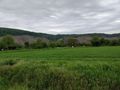
In a barley field near Filsen
Participants
- Santu
- Gefrierbrand
- Pedro the dog
Expedition
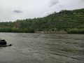
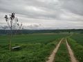
And another fun one! After work we decided to go Geohashing again. The map-survey showed a ferry crossing the Rhine river near the hashlocation and we decided to take a very narrow road to get there and use said ferry to cross the river and walk onwards from there.
The narrow road turned out to be also very steep and curvy, but fun to drive along. It had also a small parkinglot in the middle and a bench with a great view on "mill valley". We continued towards Boppard and parked in line for the ferry crossing, which was loading passengers on the other side. Looking at the timetables we noticed that we had some time left to kill and quickly wandered though a few parks along the shore before returning to the car.
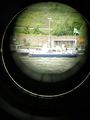
Then suddenly a police boat arrived very quickly, turned around and moored alongside the ferry. Some policemen climbed around and everybody on our side (which was surprisingly 200 m away) started wondering what's going on. First, we couldn't really make out what they were doing, but they started to fiddle around with long sticks and ropes at the front of the ferry.
Gefrierbrand then couldn't cope any longer with not-knowing what's going on and took his binoculars from the trunk to have a better look, even if it was slightly creepy. Using them, we could see that the ferry got somewhat entangled with a large tree branch and was possibly stuck.
Since our crossing was the last scheduled one for the day we worried a bit if we have to find alternate routes, but luckily the police was able to free the ferry from the wood by driving around with their boat and creating large waves on the water.
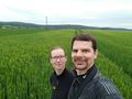
After crossing the Rhine, we drove to Filsen and continued on foot up a hill trough a forest towards the hash. We noticed quite a lot of high seats used for hunting, and one of them had a very interesting constriction which made it look like it was one-legged.
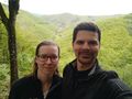
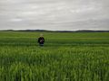
Finding the hash was relatively easy, even though we both had bad GPS reception during the entire expedition. Santu identified the grain as barley and we were able to carefully wade into the field to the location. The plants were already grown to a height were Pedro completely disappeared in them. We had some fun by hiding and letting him jump around and then took another way back towards the car.
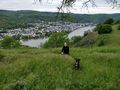
This route let us to even more nice vantage points with great views on the Rhine and Boppard, and it had lots of information boards explaining local animals, plants and terrain.
On our way back home we had no GPS reception at all and it took a while to get out of Filsen with a few wrong turns, but we eventually managed it and even drove through some nice alleys and a crooked house.
Photos
Slopy route along the way
Stupid grin on slopy road
stuck ferry
Police boat in front of ferry
interesting high seat
Santu smiling at hash
StupidGrinTM
nice view on Boppard
giant cherries
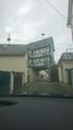
very crooked house
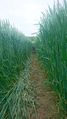
Pedro running through barley
just barely visible Pedro being fed
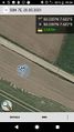
Proof


Achievements
Gefrierbrand and Santu earned the Land geohash achievement
|
Gefrierbrand and Santu earned the Ferry Achievement
|
