Difference between revisions of "2021-05-22 54 38"
(Created page with "{{subst:Expedition}}") |
(Add description!) |
||
| Line 1: | Line 1: | ||
| − | + | [[Image:{{{image|2021-05-22 54 38 Forest.jpg}}}|thumb|left]] | |
| − | + | {{meetup graticule | |
| − | [[Image:{{{image| | ||
| − | |||
| − | |||
| − | |||
| − | |||
| − | |||
| − | |||
| lat={{#explode:{{SUBPAGENAME}}| |1}} | | lat={{#explode:{{SUBPAGENAME}}| |1}} | ||
| lon={{#explode:{{SUBPAGENAME}}| |2}} | | lon={{#explode:{{SUBPAGENAME}}| |2}} | ||
| date={{#explode:{{SUBPAGENAME}}| |0}} | | date={{#explode:{{SUBPAGENAME}}| |0}} | ||
| − | }} | + | }} |
__NOTOC__ | __NOTOC__ | ||
== Location == | == Location == | ||
<!-- where you've surveyed the hash to be --> | <!-- where you've surveyed the hash to be --> | ||
| + | In fields right near SNT "Voskresenki". | ||
== Participants == | == Participants == | ||
| − | + | * [[User:V1993|V1993]] ([[User talk:V1993|talk]]) | |
| − | |||
== Plans == | == Plans == | ||
| − | + | Got really lucky to find out tomorrow's geohash was well reachable and decided to give it a go. Almost cancelled as hashpoint seemed to be on private property, but then figured it was just close to it. | |
== Expedition == | == Expedition == | ||
| − | + | First I took a bus to Stupino train station, then a train to Sitenka. From there road went trough a couple of SNTs (groups of country houses) until reaching field with hashpoint, listening to a fair amount of barking from behind fences in the process. Got to take a look at some guy unloading stuff from his car straight over the fence in rather brutal manner. | |
| + | |||
| + | Luckily for me, field itself turned out to be well walkable, with tall grass being crumpled. After waling along the fence making sure to make noise (there tend to be snakes around here), I got to the hash point. Unluckily, power line that just so happened to be there acts like a good GPS jammer, making task of accurately pinpointing hashpoint rather challenging, but I'm fairly sure I got it. | ||
| + | |||
| + | Afterwards, I took the same route back, once again using train and bus. Not nearly as exciting as my first expedition, but still well enjoyable adventure during great day! | ||
== Tracklog == | == Tracklog == | ||
| − | + | {{tracklog | 2021-05-22 54 38 v1993.gpx}} | |
| − | == Photos == | + | In case you can't see it above, tracklog is also [https://www.openstreetmap.org/user/vyo2003/traces/3677861 available at OSM]. |
| − | + | ||
| − | + | == Photos == | |
| − | |||
<gallery perrow="5"> | <gallery perrow="5"> | ||
| + | Image:2021-05-22 54 38 Road.jpg | Road | ||
| + | Image:2021-05-22 54 38 Road2.jpg | More road! | ||
| + | Image:2021-05-22 54 38 Grass.jpg | What lurks in (once) high grass? | ||
| + | Image:2021-05-22 54 38 InGrass.jpg | Other than me and some mice, I mean | ||
| + | Image:2021-05-22 54 38 GPS Jammer.jpg | GPS users hate this little trick! | ||
| + | Image:2021-05-22 54 38 Forest.jpg | Pretty forest near haspoint | ||
| + | Image:2021-05-22 54 38 Hash.jpg | Hash! | ||
| + | Image:2021-05-22 54 38 v1993.jpg | Me there | ||
| + | Image:2021-05-22 54 38 Trees.jpg | Some trees in the field | ||
| + | Image:2021-05-22 54 38 Electricity.jpg | Electricity! | ||
| + | Image:2021-05-22 54 38 Church.jpg | Local church | ||
| + | Image:2021-05-22 54 38 Rails.jpg | Rather minimalistic train station Sitenka | ||
</gallery> | </gallery> | ||
== Achievements == | == Achievements == | ||
{{#vardefine:ribbonwidth|800px}} | {{#vardefine:ribbonwidth|800px}} | ||
| − | + | {{land geohash | |
| − | + | | latitude = 54 | |
| − | + | | longitude = 38 | |
| − | + | | date = 2021-05-22 | |
| − | + | }} | |
| − | + | {{Public transport geohash | |
| − | + | | latitude = 54 | |
| − | + | | longitude = 38 | |
| − | + | | date = 2021-05-22 | |
| − | + | | busline = buses and trains | |
| − | + | }} | |
| − | |||
| − | |||
| − | |||
| − | |||
[[Category:Expeditions]] | [[Category:Expeditions]] | ||
| − | |||
[[Category:Expeditions with photos]] | [[Category:Expeditions with photos]] | ||
| − | |||
| − | |||
| − | |||
| − | |||
| − | |||
[[Category:Coordinates reached]] | [[Category:Coordinates reached]] | ||
| − | |||
| − | |||
| − | |||
| − | |||
| − | |||
| − | |||
| − | |||
| − | |||
| − | |||
| − | |||
| − | |||
| − | |||
| − | |||
| − | |||
| − | |||
| − | |||
| − | |||
| − | |||
Revision as of 13:20, 22 May 2021

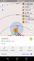
| Sat 22 May 2021 in 54,38: 54.9459240, 38.0762402 geohashing.info google osm bing/os kml crox |
Location
In fields right near SNT "Voskresenki".
Participants
Plans
Got really lucky to find out tomorrow's geohash was well reachable and decided to give it a go. Almost cancelled as hashpoint seemed to be on private property, but then figured it was just close to it.
Expedition
First I took a bus to Stupino train station, then a train to Sitenka. From there road went trough a couple of SNTs (groups of country houses) until reaching field with hashpoint, listening to a fair amount of barking from behind fences in the process. Got to take a look at some guy unloading stuff from his car straight over the fence in rather brutal manner.
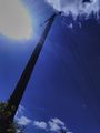
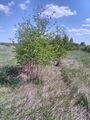
Luckily for me, field itself turned out to be well walkable, with tall grass being crumpled. After waling along the fence making sure to make noise (there tend to be snakes around here), I got to the hash point. Unluckily, power line that just so happened to be there acts like a good GPS jammer, making task of accurately pinpointing hashpoint rather challenging, but I'm fairly sure I got it.
Afterwards, I took the same route back, once again using train and bus. Not nearly as exciting as my first expedition, but still well enjoyable adventure during great day!
Tracklog
In case you can't see it above, tracklog is also available at OSM.
Photos
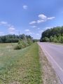
Road
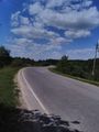
More road!
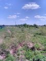
What lurks in (once) high grass?
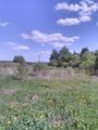
Other than me and some mice, I mean
GPS users hate this little trick!
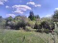
Pretty forest near haspoint
Hash!

Me there
Some trees in the field
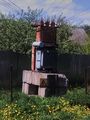
Electricity!
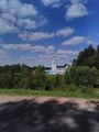
Local church
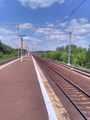
Rather minimalistic train station Sitenka


Achievements
This user earned the Land geohash achievement
|
This user earned the Public transport geohash achievement
|