Difference between revisions of "2021-05-26 39 -4"
From Geohashing
(Created page with "{{subst:Expedition |lat = 39 |lon = -4 |date = 2021-05-26 }}") |
|||
| Line 15: | Line 15: | ||
== Location == | == Location == | ||
<!-- where you've surveyed the hash to be --> | <!-- where you've surveyed the hash to be --> | ||
| + | Directly by the side of the road near Torrijos. | ||
== Participants == | == Participants == | ||
<!-- who attended: If you link to your wiki user name in this section, your expedition will be picked up by the various statistics generated for geohashing. You may use three tildes ~ as a shortcut to automatically insert the user signature of the account you are editing with. | <!-- who attended: If you link to your wiki user name in this section, your expedition will be picked up by the various statistics generated for geohashing. You may use three tildes ~ as a shortcut to automatically insert the user signature of the account you are editing with. | ||
--> | --> | ||
| + | [[User:Wingman|Wingman]] ([[User talk:Wingman|talk]]) | ||
== Plans == | == Plans == | ||
| Line 25: | Line 27: | ||
== Expedition == | == Expedition == | ||
<!-- how it all turned out. your narrative goes here. --> | <!-- how it all turned out. your narrative goes here. --> | ||
| + | My first (successful) geohash. | ||
| + | |||
| + | This looked like an easy one, directly by the side of the road. And it was. | ||
| + | |||
| + | I left (home) office early at 16:30 for a nice one hour ride on a warm and sunny day. Just a few meters from the geohash there was some space beside the road where I could safely park the bike. Took Photos and rode back. | ||
| + | Indeed an easy one. | ||
== Tracklog == | == Tracklog == | ||
| Line 34: | Line 42: | ||
--> | --> | ||
<gallery perrow="5"> | <gallery perrow="5"> | ||
| + | Image:2021-05-22 39 L1040272.JPG | Proof (and kind of a selfie). | ||
| + | Image:2021-05-22 39 -4 L1040267.JPG | The geohash is on the other side of the road, near the center of the image, where the little plastic tube lays (I didn't bring it, just relocated it by a few meters). | ||
</gallery> | </gallery> | ||
| Line 53: | Line 63: | ||
<!-- If all those plans are never acted upon, change [[Category:Expedition planning]] to [[Category:Not reached - Did not attempt]]. --> | <!-- If all those plans are never acted upon, change [[Category:Expedition planning]] to [[Category:Not reached - Did not attempt]]. --> | ||
| − | |||
[[Category:Expeditions]] | [[Category:Expeditions]] | ||
| − | |||
[[Category:Expeditions with photos]] | [[Category:Expeditions with photos]] | ||
| + | <!-- An actual expedition: | ||
[[Category:Expeditions with videos]] | [[Category:Expeditions with videos]] | ||
[[Category:Expedition without GPS]] | [[Category:Expedition without GPS]] | ||
--> | --> | ||
| + | [[Category:Coordinates reached]] | ||
<!-- if you reached your coords: | <!-- if you reached your coords: | ||
| − | |||
Revision as of 17:17, 27 May 2021
| Wed 26 May 2021 in 39,-4: 39.9922151, -4.3184964 geohashing.info google osm bing/os kml crox |
Location
Directly by the side of the road near Torrijos.
Participants
Plans
Expedition
My first (successful) geohash.
This looked like an easy one, directly by the side of the road. And it was.
I left (home) office early at 16:30 for a nice one hour ride on a warm and sunny day. Just a few meters from the geohash there was some space beside the road where I could safely park the bike. Took Photos and rode back. Indeed an easy one.
Tracklog
Photos
- 2021-05-22 39 L1040272.JPG
Proof (and kind of a selfie).
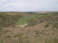
The geohash is on the other side of the road, near the center of the image, where the little plastic tube lays (I didn't bring it, just relocated it by a few meters).
