Difference between revisions of "2021-06-06 40 -4"
(→Expedition) |
(→Photos) |
||
| Line 71: | Line 71: | ||
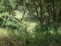
Image:2021-06-06_40_-4_L1040298.JPG | Was first thinking I had to fight my way through a thorn hedge like sleeping beauty's prince charming... | Image:2021-06-06_40_-4_L1040298.JPG | Was first thinking I had to fight my way through a thorn hedge like sleeping beauty's prince charming... | ||
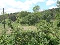
Image:2021-06-06_40_-4_L1040286.JPG | ... but a few meters along the hedge was a path through. | Image:2021-06-06_40_-4_L1040286.JPG | ... but a few meters along the hedge was a path through. | ||
| − | Image:2021-06-06_40_-4_L1040287.JPG | Through | + | Image:2021-06-06_40_-4_L1040287.JPG | Through thistles towards the geohash. Here they are still green, while the later expedition [[2021-06-18_40_-3]] ended up in a field of dried out ones. |
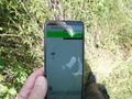
Image:2021-06-06_40_-4_L1040291.JPG | Here we are, proof and kind of selfie. | Image:2021-06-06_40_-4_L1040291.JPG | Here we are, proof and kind of selfie. | ||
Image:2021-06-06_40_-4_L1040292.JPG | I put the dead branch at the point. | Image:2021-06-06_40_-4_L1040292.JPG | I put the dead branch at the point. | ||
Latest revision as of 07:46, 11 January 2022
| Sun 6 Jun 2021 in 40,-4: 40.5228441, -4.5620088 geohashing.info google osm bing/os kml crox |
Location
Nowhere, about 50 meters off a small road near Bartolomé de Pinares.
Participants
Plans
Expedition
The geohash was an about one hour ride from my home. There were two alternative routes, one over small roads, presumably quite scenic, and another one mostly over main roads, a little bit longer, but faster. I decided to take the scenic one outbound and the faster one inbound.
The outbound ride was indeed very nice. It went through a beautiful part of the Sierra Oeste, crossing some mountain passes. I reached a maximum height of 1223 meters. The road between Cebreros and Bartolomé de Pinares was particularly impressive, offering spectacular views, and there's almost no traffic. On expedition 2021-10-12_40_-4, I got there again, and that time, I stopped for a photo.
Parking near the geohash at the side of the road was a bit suboptimal, but with so few traffic, it was OK. The geohash was very close to the road, but I had to find my way through some wilderness, see photos.
The ride back home was quite laid back. I passed the large reservoir Embalse del Borguillo, which has very nice beaches, and got home well.
Tracklog
Photos
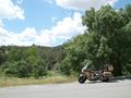
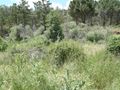
As close as paved roads could get me. The geohash is about 50 meters in the viewing direction.
Was first thinking I had to fight my way through a thorn hedge like sleeping beauty's prince charming...
... but a few meters along the hedge was a path through.
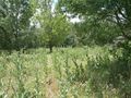
Through thistles towards the geohash. Here they are still green, while the later expedition 2021-06-18_40_-3 ended up in a field of dried out ones.
Here we are, proof and kind of selfie.
I put the dead branch at the point.


