Difference between revisions of "2021-06-08 50 7"
From Geohashing
Gefrierbrand (talk | contribs) (→Expedition) |
Gefrierbrand (talk | contribs) |
||
| (11 intermediate revisions by 2 users not shown) | |||
| Line 14: | Line 14: | ||
__NOTOC__ | __NOTOC__ | ||
== Location == | == Location == | ||
| − | + | In a field near Minkelfeld | |
== Participants == | == Participants == | ||
| − | *Gefrierbrand | + | *[[User:Gefrierbrand|Gefrierbrand]] |
| − | *Santu | + | *[[User:Santu|Santu]] |
*Pedro the dog | *Pedro the dog | ||
| Line 25: | Line 25: | ||
== Expedition == | == Expedition == | ||
| − | *drove to | + | *drove to Minkelfeld |
*tried to visit church, but it was locked | *tried to visit church, but it was locked | ||
*walked short distance to hash, bad smell and old semi-abandoned gear being held together by straps | *walked short distance to hash, bad smell and old semi-abandoned gear being held together by straps | ||
| Line 40: | Line 40: | ||
== Photos == | == Photos == | ||
| − | |||
| − | |||
| − | |||
<gallery perrow="5"> | <gallery perrow="5"> | ||
| − | + | Image:2021-06-08_50_7_Gefrierbrand_1623165945976.jpg|overview | |
| − | Image:2021-06-08_50_7_Gefrierbrand_1623165945976.jpg|overview | + | Image:2021-06-08_50_7_Gefrierbrand_1623180159015.jpg|proof |
| − | + | Image:2021-06-08_50_7_Gefrierbrand_1623180241492.jpg|StupidGrin<sup>TM</sup> with Pedro | |
| − | Image:2021-06-08_50_7_Gefrierbrand_1623180159015.jpg|proof | + | Image:2021-06-08_50_7_Gefrierbrand_1623227698476.jpg|St. Marcus |
| − | |||
| − | Image:2021-06-08_50_7_Gefrierbrand_1623180241492.jpg| | ||
</gallery> | </gallery> | ||
== Achievements == | == Achievements == | ||
{{#vardefine:ribbonwidth|800px}} | {{#vardefine:ribbonwidth|800px}} | ||
| − | + | {{land geohash | |
| − | + | | latitude = 50 | |
| − | + | | longitude = 7 | |
| − | + | | date = 2021-06-08 | |
| − | + | | name = Santu & Gefrierbrand | |
| + | }} | ||
| + | {{Geotrash | ||
| + | | latitude = 50 | ||
| + | | longitude = 7 | ||
| + | | date = 2021-06-08 | ||
| + | | name = Santu & Gefrierbrand | ||
| + | }} | ||
| + | {{OpenStreetMap achievement | ||
| + | | latitude = 50 | ||
| + | | longitude = 7 | ||
| + | | date = 2021-06-08 | ||
| + | | OSMlink = 106081958 | ||
| + | | name = Gefrierbrand | ||
| + | }} | ||
| − | |||
| − | |||
| − | |||
| − | |||
| − | |||
| − | |||
| − | |||
| − | |||
| − | |||
| − | |||
[[Category:Expeditions]] | [[Category:Expeditions]] | ||
| − | |||
[[Category:Expeditions with photos]] | [[Category:Expeditions with photos]] | ||
| − | |||
| − | |||
| − | |||
| − | |||
| − | |||
[[Category:Coordinates reached]] | [[Category:Coordinates reached]] | ||
| − | + | [[Category:Expeditions with dogs]] | |
| − | + | {{location|DE|RP|MYK}} | |
| − | |||
| − | |||
| − | |||
| − | |||
| − | |||
| − | |||
| − | |||
| − | |||
| − | |||
| − | |||
| − | [[Category: | ||
| − | |||
| − | |||
| − | |||
| − | |||
| − | |||
Latest revision as of 07:56, 18 October 2022
| Tue 8 Jun 2021 in 50,7: 50.3185612, 7.3786800 geohashing.info google osm bing/os kml crox |
Location
In a field near Minkelfeld
Participants
- Gefrierbrand
- Santu
- Pedro the dog
Plans
Expedition
- drove to Minkelfeld
- tried to visit church, but it was locked
- walked short distance to hash, bad smell and old semi-abandoned gear being held together by straps
- walked carefully into field using tracks
- reached point, took celebratory pictures
- continued walking around
- dizzy view, hot and moist, but nice area
- picked up litter
- "chased" butterfly
- returned home
Tracklog
Photos
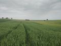
overview
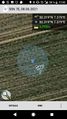
proof
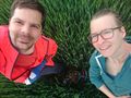
StupidGrinTM with Pedro
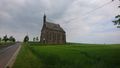
St. Marcus


Achievements
Santu & Gefrierbrand earned the Land geohash achievement
|
Santu & Gefrierbrand earned the GeoTrash Geohash Achievement
|
Gefrierbrand earned the OpenStreetMap achievement
|