Difference between revisions of "2021-06-11 50 7"
(Created page with "{{subst:Expedition}}") |
(→Tracklog) |
||
| (7 intermediate revisions by 2 users not shown) | |||
| Line 1: | Line 1: | ||
| − | + | [[Image:{{{image|2021-06-11 50 7 cover.jpg}}}|thumb|left]] | |
| − | + | {{meetup graticule | |
| − | |||
| − | |||
| − | |||
| − | |||
| − | |||
| − | |||
| lat={{#explode:{{SUBPAGENAME}}| |1}} | | lat={{#explode:{{SUBPAGENAME}}| |1}} | ||
| lon={{#explode:{{SUBPAGENAME}}| |2}} | | lon={{#explode:{{SUBPAGENAME}}| |2}} | ||
| date={{#explode:{{SUBPAGENAME}}| |0}} | | date={{#explode:{{SUBPAGENAME}}| |0}} | ||
| − | }} | + | }} |
__NOTOC__ | __NOTOC__ | ||
== Location == | == Location == | ||
| − | + | A field just outside of Remagen-Oedingen. There’s a footpath that passes by GZ at about 15 m distance, and from the satellite photo it looks like there’s only some minor agriculture, no significant obstacle, in the way. | |
== Participants == | == Participants == | ||
| − | + | * [[User:Mirabilos|mirabilos]] ([[User talk:Mirabilos|talk]]) 2906﹟ | |
| − | + | * eyeinthesky (his SO) | |
== Plans == | == Plans == | ||
| − | + | mirabilos +1 intends to be there by 20:30 localtime (18:30 UTC) because 16:00 would be too hot. We plan on geocaching around the area as well, probably afterwards. | |
| + | |||
| + | I’ll place a virtual Munzee right on the spot and a physical Munzee as close-by as possible. | ||
== Expedition == | == Expedition == | ||
| − | + | We ended up having to hurry a bit, but there was a nice parking lot nearby at the Dorfgemeindehaus and local football (soccer, for you Amis) kicking ground, from which we could reach a path towards the hashpoint. | |
| + | |||
| + | The agriculture at this time of day started out with gooseberries; however, GZ had currants instead. Either not yet ripe. | ||
| + | |||
| + | Against expectations I was able to walk on grass between the delicious(but later) shrubs to get within ±1m (plus uncertainty bubble) of GZ. I had borrowed some chalk from the neighbours’ kids, but the path wasn’t tarred so a wooden post had to do for a (environment-friendly) marker. | ||
| + | |||
| + | We managed to arrive around 20:25 and stuck around until about 20:35 localtime. I’ve published a Virtual Munzee right on the spot, and eyeinthesky put a physical Munzee on a metal part of the wooden post closest to the path. We then went on geocaching (but there was no hash collision with one, the nearest one I found was some hundred metres further). | ||
== Tracklog == | == Tracklog == | ||
| − | + | [[Image:{{{image|2021-06-11_50_7_trail.jpg}}}|thumb]] | |
| + | {{tracklog | 2021-06-11_50_7_trail.gpx}} | ||
== Photos == | == Photos == | ||
| − | + | ||
| − | |||
| − | |||
<gallery perrow="5"> | <gallery perrow="5"> | ||
| + | Image:2021-06-11 50 7 cover.jpg|Walking towards the path, looking into the direction of GZ | ||
| + | Image:2021-06-11 50 7 path.jpg|The path towards Ground Zero | ||
| + | Image:2021-06-11 50 7 marker.jpg|The marker we left, in chalk… sorry for being boring, it was '''hot''' | ||
| + | Image:2021-06-11 50 7 ground-zero.jpg|Looking back towards the path, the dashpoint in focus | ||
</gallery> | </gallery> | ||
| Line 39: | Line 44: | ||
{{#vardefine:ribbonwidth|800px}} | {{#vardefine:ribbonwidth|800px}} | ||
<!-- Add any achievement ribbons you earned below, or remove this section --> | <!-- Add any achievement ribbons you earned below, or remove this section --> | ||
| + | to be done | ||
| − | |||
| − | |||
| − | |||
| − | |||
| − | |||
| − | |||
| − | |||
| − | |||
| − | |||
| − | |||
| − | |||
| − | |||
| − | |||
[[Category:Expeditions]] | [[Category:Expeditions]] | ||
| − | |||
[[Category:Expeditions with photos]] | [[Category:Expeditions with photos]] | ||
| − | |||
| − | |||
| − | |||
| − | |||
| − | |||
[[Category:Coordinates reached]] | [[Category:Coordinates reached]] | ||
| − | + | {{location|DE|RP|AW}} | |
| − | |||
| − | |||
| − | |||
| − | |||
| − | |||
| − | |||
| − | |||
| − | |||
| − | |||
| − | |||
| − | |||
| − | |||
| − | |||
| − | |||
| − | |||
| − | |||
| − | |||
Latest revision as of 19:23, 3 December 2021

| Fri 11 Jun 2021 in 50,7: 50.6035520, 7.1620612 geohashing.info google osm bing/os kml crox |
Location
A field just outside of Remagen-Oedingen. There’s a footpath that passes by GZ at about 15 m distance, and from the satellite photo it looks like there’s only some minor agriculture, no significant obstacle, in the way.
Participants
Plans
mirabilos +1 intends to be there by 20:30 localtime (18:30 UTC) because 16:00 would be too hot. We plan on geocaching around the area as well, probably afterwards.
I’ll place a virtual Munzee right on the spot and a physical Munzee as close-by as possible.
Expedition
We ended up having to hurry a bit, but there was a nice parking lot nearby at the Dorfgemeindehaus and local football (soccer, for you Amis) kicking ground, from which we could reach a path towards the hashpoint.
The agriculture at this time of day started out with gooseberries; however, GZ had currants instead. Either not yet ripe.
Against expectations I was able to walk on grass between the delicious(but later) shrubs to get within ±1m (plus uncertainty bubble) of GZ. I had borrowed some chalk from the neighbours’ kids, but the path wasn’t tarred so a wooden post had to do for a (environment-friendly) marker.
We managed to arrive around 20:25 and stuck around until about 20:35 localtime. I’ve published a Virtual Munzee right on the spot, and eyeinthesky put a physical Munzee on a metal part of the wooden post closest to the path. We then went on geocaching (but there was no hash collision with one, the nearest one I found was some hundred metres further).
Tracklog

Photos
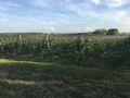
Walking towards the path, looking into the direction of GZ
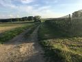
The path towards Ground Zero
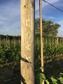
The marker we left, in chalk… sorry for being boring, it was hot
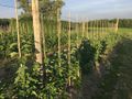
Looking back towards the path, the dashpoint in focus


Achievements
to be done