Difference between revisions of "2021-07-17 47 10"
(Created page with "{{subst:Expedition}}") |
|||
| Line 1: | Line 1: | ||
| − | + | [[Image:{{{image|2021-07-17 47 10 Flora.jpeg}}}|thumb|left]] | |
| − | + | {{meetup graticule | |
| − | [[Image:{{{image| | ||
| − | |||
| − | |||
| − | |||
| − | |||
| − | |||
| − | |||
| lat={{#explode:{{SUBPAGENAME}}| |1}} | | lat={{#explode:{{SUBPAGENAME}}| |1}} | ||
| lon={{#explode:{{SUBPAGENAME}}| |2}} | | lon={{#explode:{{SUBPAGENAME}}| |2}} | ||
| date={{#explode:{{SUBPAGENAME}}| |0}} | | date={{#explode:{{SUBPAGENAME}}| |0}} | ||
| − | }} | + | }} |
| + | |||
__NOTOC__ | __NOTOC__ | ||
== Location == | == Location == | ||
| − | + | Just outside the village of Lähn, a short distance into the forest. | |
== Participants == | == Participants == | ||
| − | + | [[User:Dirimwar|Dirimwar]] ([[User talk:Dirimwar|talk]]) | |
| − | |||
== Plans == | == Plans == | ||
| − | + | Not one, but [[2021-07-17 47 11|two]] hashes easily reachable by train in a single day? This calls for a multihash! | |
| + | |||
| + | The basic plan: starting in Innsbruck, take the train to Lähn, get the hash, take the train back to Innsbruck and straight on to Münster, get that hash, then go back. | ||
| + | |||
| + | This will be my first ever attempted hash! | ||
== Expedition == | == Expedition == | ||
| − | + | ||
| + | After waking up from an awfully short night's worth of sleep, I started packing my stuff. The weather was quite gloomy and miserable, and was forecast to get worse, so I packed plenty of rain protection and spare clothes. The schedule was a tight one: I'd be spending most of my day on the train, and have only 40 minutes to get the first hash. | ||
| + | |||
| + | I got on the S6 train to Garmisch at 10:38, and after a 1.5h ride with some nice (though cloudy) views of the Inn valley, I changed to the RB5514 for the final leg. It had been raining on and off for the entire journey, but just before arriving in Lähn at 12:40, it cleared right up and the sun started to show! | ||
| + | |||
| + | Because I didn't know how long it would take me to actually get to the hash and back, I legged it as far as I could. Eventually, after walking along an unused pasture, I got to the forest - unfortunately, what I had hoped would be a nice flat and dry coniferous forest floor turned out to be a steep, uneven and wet meadow almost a meter deep in some spots. Needless to say, getting to the hash was a bit of a challenge, but I got close enough eventually. After securing the proof and taking some pictures of the surrounding greenery, I made my way back down (another slippery undertaking) and back to the train stop - much less rushed this time, still having over half my allotted time left. Just as I got on the train, it started raining again. | ||
| + | |||
| + | The adventure continues in [[2021-07-17 47 11|the next graticule]]. | ||
== Tracklog == | == Tracklog == | ||
| − | + | {{tracklog|2021-07-17 47 10 Dirimwar.gpx}} | |
| − | == Photos == | + | == Photos == |
| − | <!-- Insert pictures between the gallery tags using the following format: | + | <!-- Insert pictures between the gallery tags using the following format: |
Image:2020-##-## ## ## Alpha.jpg | Witty Comment | Image:2020-##-## ## ## Alpha.jpg | Witty Comment | ||
--> | --> | ||
<gallery perrow="5"> | <gallery perrow="5"> | ||
| + | File:2021-07-17 47 10 proof.png | Proof | ||
| + | File:2021-07-17 47 10 Flora.jpeg | Lots of green | ||
| + | File:2021-07-17 47 10 Into the forest.jpeg | Heading into the forest, the hash point is up the slope on the left | ||
</gallery> | </gallery> | ||
== Achievements == | == Achievements == | ||
{{#vardefine:ribbonwidth|800px}} | {{#vardefine:ribbonwidth|800px}} | ||
| − | |||
| − | + | {{land geohash | |
| − | + | | latitude = 47 | |
| − | [[ | + | | longitude = 10 |
| + | | date = 2021-07-17 | ||
| + | | name = [[User:Dirimwar|Dirimwar]] | ||
| + | }} | ||
| − | + | {{Public transport geohash | |
| + | | latitude = 47 | ||
| + | | longitude = 10 | ||
| + | | date = 2021-07-17 | ||
| + | | name = [[User:Dirimwar|Dirimwar]] | ||
| + | }} | ||
| − | + | {{Two to the N achievement | |
| − | + | | count = 0 | |
| − | [[ | + | | date = 2021-07-17 |
| − | - | + | | latitude = 47 |
| + | | longitude = 10 | ||
| + | | name = [[User:Dirimwar|Dirimwar]] | ||
| + | | reached = true (optional - include if you are counting coordinates reached) | ||
| + | }} | ||
| − | |||
| − | |||
| − | |||
[[Category:Expeditions]] | [[Category:Expeditions]] | ||
| − | |||
[[Category:Expeditions with photos]] | [[Category:Expeditions with photos]] | ||
| − | |||
| − | |||
| − | |||
| − | |||
| − | |||
[[Category:Coordinates reached]] | [[Category:Coordinates reached]] | ||
| − | |||
| − | |||
| − | |||
| − | |||
| − | |||
| − | |||
| − | |||
| − | |||
| − | |||
| − | |||
| − | |||
| − | |||
| − | |||
| − | |||
| − | |||
| − | |||
| − | |||
| − | |||
Revision as of 12:49, 18 July 2021

| Sat 17 Jul 2021 in 47,10: 47.4157251, 10.8332640 geohashing.info google osm bing/os kml crox |
Location
Just outside the village of Lähn, a short distance into the forest.
Participants
Plans
Not one, but two hashes easily reachable by train in a single day? This calls for a multihash!
The basic plan: starting in Innsbruck, take the train to Lähn, get the hash, take the train back to Innsbruck and straight on to Münster, get that hash, then go back.
This will be my first ever attempted hash!
Expedition
After waking up from an awfully short night's worth of sleep, I started packing my stuff. The weather was quite gloomy and miserable, and was forecast to get worse, so I packed plenty of rain protection and spare clothes. The schedule was a tight one: I'd be spending most of my day on the train, and have only 40 minutes to get the first hash.
I got on the S6 train to Garmisch at 10:38, and after a 1.5h ride with some nice (though cloudy) views of the Inn valley, I changed to the RB5514 for the final leg. It had been raining on and off for the entire journey, but just before arriving in Lähn at 12:40, it cleared right up and the sun started to show!
Because I didn't know how long it would take me to actually get to the hash and back, I legged it as far as I could. Eventually, after walking along an unused pasture, I got to the forest - unfortunately, what I had hoped would be a nice flat and dry coniferous forest floor turned out to be a steep, uneven and wet meadow almost a meter deep in some spots. Needless to say, getting to the hash was a bit of a challenge, but I got close enough eventually. After securing the proof and taking some pictures of the surrounding greenery, I made my way back down (another slippery undertaking) and back to the train stop - much less rushed this time, still having over half my allotted time left. Just as I got on the train, it started raining again.
The adventure continues in the next graticule.
Tracklog
Photos

Proof
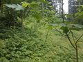
Lots of green
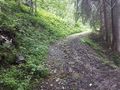
Heading into the forest, the hash point is up the slope on the left


Achievements
Dirimwar earned the Land geohash achievement
|
Dirimwar earned the Public transport geohash achievement
|
