Difference between revisions of "2021-07-19 47 12"
(Created page with "{{subst:Expedition}}") |
|||
| (2 intermediate revisions by 2 users not shown) | |||
| Line 1: | Line 1: | ||
| − | + | [[Image:{{{image|2021-07-19 47 12 Slope.jpeg}}}|thumb|left]] | |
| − | + | {{meetup graticule | |
| − | |||
| − | |||
| − | |||
| − | |||
| − | |||
| − | |||
| lat={{#explode:{{SUBPAGENAME}}| |1}} | | lat={{#explode:{{SUBPAGENAME}}| |1}} | ||
| lon={{#explode:{{SUBPAGENAME}}| |2}} | | lon={{#explode:{{SUBPAGENAME}}| |2}} | ||
| date={{#explode:{{SUBPAGENAME}}| |0}} | | date={{#explode:{{SUBPAGENAME}}| |0}} | ||
| − | }} | + | }} |
| + | |||
__NOTOC__ | __NOTOC__ | ||
== Location == | == Location == | ||
| − | + | In a forest in Kiefersfelden, just across the Austrian-German border. | |
== Participants == | == Participants == | ||
| − | + | [[User:Dirimwar|Dirimwar]] ([[User talk:Dirimwar|talk]]) | |
| − | |||
== Plans == | == Plans == | ||
| − | + | Take the train to Kiefersfelden, hike up to the hash. | |
== Expedition == | == Expedition == | ||
| − | + | I managed to convince my dad to come along for a nice mountain hike. Instead of going to Kiefersfelden by train as originally planned, we decided to only go to Kufstein and walk the rest of the way - a relaxed 1.5h walk throught the forest according to [https://osmand.net/ OsmAnd]. | |
| + | |||
| + | We met up at Innsbruck central station for the 14:40 Eurocity headed for Munich. After buying some snacks, I was quite annoyed to discover that the train was delayed by two whole hours. Our next best option was the 14:35 S-Bahn, but it would take us 1h15min instead of 45min. So, we promptly misread the platform on the departure list and hopped on the wrong train - while we noticed pretty quickly after it had started moving in the wrong direction, the correct train had long left when we got back to the station. Instead, we got on the 15:20 REX and ''finally'' arrived in Kufstein at 16:24. | ||
| + | |||
| + | We started walking along the Inn until we got to the freeway bridge. Through a tiny underpass, we crossed the train tracks and continued on to the federal highway where, a short distance later, a small forest path branches off to the left. We walked along the shady path for about 20 minutes, crossed a very picturesque meadow and then made our way up to the Buchberg cross. From there, the path degraded from a gravelled forest road into a small, muddy trail. A few minutes later, the GPS told us the hash was in the woods right abeam. | ||
| + | |||
| + | After an initial wall of shrubbery, we were greeted by a steep, but otherwise very navigable forest floor. The hash was about 40-50m out, so we started making our way downhill. About 10m from the hashpoint, still outside the awfully good GPS accuracy, we were stopped by the sudden appearance of a cliff! Not wanting to fall victim to mother nature ''this close'' to the hash, I scouted around a bit and found an outcropping that just barely put me close enough to the hash - I took proof and we quickly made our way back to safer ground. | ||
| + | |||
| + | A short snack break at the Buchberg cross later, we made our way back down to Kiefersfelden station to catch the 18:54 train back home. Avoiding any [[Train_wreck_consolation_prize|train wrecks]] this time, we arrived at Innsbruck station at 19:46, concluding a fun afternoon with at least 8 border crossings :) | ||
== Tracklog == | == Tracklog == | ||
| − | + | {{tracklog|2021-07-19 47 12 Dirimwar.gpx}} | |
| − | == Photos == | + | == Photos == |
| − | <!-- Insert pictures between the gallery tags using the following format: | + | <!-- Insert pictures between the gallery tags using the following format: |
Image:2020-##-## ## ## Alpha.jpg | Witty Comment | Image:2020-##-## ## ## Alpha.jpg | Witty Comment | ||
--> | --> | ||
<gallery perrow="5"> | <gallery perrow="5"> | ||
| + | File:2021-07-19 47 12 border stone Austria.jpeg | A border stone, Austrian side | ||
| + | File:2021-07-19 47 12 border stone Germany.jpeg | Same border stone, German side | ||
| + | File:2021-07-19 47 12 blob spotting.jpeg | A nice view down from the Buchberg cross with a glimpse of one of the highly elusive [https://xkcd.com/2472/ fuzzy blobs] | ||
| + | 2021-07-19 47 12 proof.png | Proof! | ||
</gallery> | </gallery> | ||
== Achievements == | == Achievements == | ||
{{#vardefine:ribbonwidth|800px}} | {{#vardefine:ribbonwidth|800px}} | ||
| − | |||
| − | |||
| − | |||
| − | |||
| − | |||
| − | + | {{Border geohash achievement | |
| + | | latitude = 47 | ||
| + | | longitude = 12 | ||
| + | | date = 2021-07-19 | ||
| + | | country1 = Austria | ||
| + | | country2 = Germany | ||
| + | | name = [[User:Dirimwar|Dirimwar]] | ||
| + | }} | ||
| − | + | {{drag-along | |
| − | + | | latitude = 47 | |
| − | [[ | + | | longitude = 12 |
| − | + | | date = 2021-07-19 | |
| + | | partner = his dad | ||
| + | | name = [[User:Dirimwar|Dirimwar]] | ||
| + | }} | ||
| − | + | {{Minesweeper geohash | |
| + | | graticule = Innsbruck, Austria | ||
| + | | ranknumber = 2 | ||
| + | | e = true | ||
| + | | w = true | ||
| + | | name = [[User:Dirimwar|Dirimwar]] | ||
| + | }} | ||
| − | |||
[[Category:Expeditions]] | [[Category:Expeditions]] | ||
| − | |||
[[Category:Expeditions with photos]] | [[Category:Expeditions with photos]] | ||
| − | |||
| − | |||
| − | |||
| − | |||
| − | |||
[[Category:Coordinates reached]] | [[Category:Coordinates reached]] | ||
| − | + | {{location|DE|BY|RO}} | |
| − | |||
| − | |||
| − | |||
| − | |||
| − | |||
| − | |||
| − | |||
| − | |||
| − | |||
| − | |||
| − | |||
| − | |||
| − | |||
| − | |||
| − | |||
| − | |||
Latest revision as of 16:31, 26 August 2021

| Mon 19 Jul 2021 in 47,12: 47.6153023, 12.1767152 geohashing.info google osm bing/os kml crox |
Location
In a forest in Kiefersfelden, just across the Austrian-German border.
Participants
Plans
Take the train to Kiefersfelden, hike up to the hash.
Expedition
I managed to convince my dad to come along for a nice mountain hike. Instead of going to Kiefersfelden by train as originally planned, we decided to only go to Kufstein and walk the rest of the way - a relaxed 1.5h walk throught the forest according to OsmAnd.
We met up at Innsbruck central station for the 14:40 Eurocity headed for Munich. After buying some snacks, I was quite annoyed to discover that the train was delayed by two whole hours. Our next best option was the 14:35 S-Bahn, but it would take us 1h15min instead of 45min. So, we promptly misread the platform on the departure list and hopped on the wrong train - while we noticed pretty quickly after it had started moving in the wrong direction, the correct train had long left when we got back to the station. Instead, we got on the 15:20 REX and finally arrived in Kufstein at 16:24.
We started walking along the Inn until we got to the freeway bridge. Through a tiny underpass, we crossed the train tracks and continued on to the federal highway where, a short distance later, a small forest path branches off to the left. We walked along the shady path for about 20 minutes, crossed a very picturesque meadow and then made our way up to the Buchberg cross. From there, the path degraded from a gravelled forest road into a small, muddy trail. A few minutes later, the GPS told us the hash was in the woods right abeam.
After an initial wall of shrubbery, we were greeted by a steep, but otherwise very navigable forest floor. The hash was about 40-50m out, so we started making our way downhill. About 10m from the hashpoint, still outside the awfully good GPS accuracy, we were stopped by the sudden appearance of a cliff! Not wanting to fall victim to mother nature this close to the hash, I scouted around a bit and found an outcropping that just barely put me close enough to the hash - I took proof and we quickly made our way back to safer ground.
A short snack break at the Buchberg cross later, we made our way back down to Kiefersfelden station to catch the 18:54 train back home. Avoiding any train wrecks this time, we arrived at Innsbruck station at 19:46, concluding a fun afternoon with at least 8 border crossings :)
Tracklog
Photos
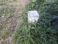
A border stone, Austrian side
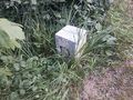
Same border stone, German side
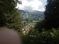
A nice view down from the Buchberg cross with a glimpse of one of the highly elusive fuzzy blobs
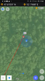
Proof!


Achievements
Dirimwar earned the Border geohash achievement
|
Dirimwar earned the Drag-along achievement
|
Dirimwar achieved level 2 of the Minesweeper Geohash achievement
|