Difference between revisions of "2021-07-24 52 5"
(Created page with "{{subst:Expedition}}") |
m (Location) |
||
| (One intermediate revision by one other user not shown) | |||
| Line 14: | Line 14: | ||
__NOTOC__ | __NOTOC__ | ||
== Location == | == Location == | ||
| − | + | On the Arnhemseweg in Driebergen. | |
== Participants == | == Participants == | ||
| − | + | [[User:Xnyhps|Xnyhps]] ([[User talk:Xnyhps|talk]]) | |
| − | |||
== Plans == | == Plans == | ||
| − | + | The Saturday the week before I happened to be cycling pas the Arnhemseweg as well. That was not a great experience. The cycle path is narrow, there were a lot of other cyclists and it was a busy road. I remembered thinking to myself "better not take this route again on a sunny Saturday". So of course, the next week on Saturday, the geohash lands exactly on this road... | |
| + | |||
| + | I decided to go for it anyway and picked out a route that would take me over this road as little as possible. | ||
== Expedition == | == Expedition == | ||
| − | + | The weather was great, but not as sunny as the week before, so also less busy. I cycled from Zeist over the Driebergseweg and then through Park Sparrendaal, which was a much better route. I went to the point, which was in the middle of the road. I crossed the road at the approximate place, but because it was quite busy didn't try to take a picture while there. | |
| − | |||
| − | |||
| − | |||
== Photos == | == Photos == | ||
| Line 34: | Line 32: | ||
--> | --> | ||
<gallery perrow="5"> | <gallery perrow="5"> | ||
| + | File:Park_Sparrendaal_Driebergen.jpeg | Park Sparrendaal where I took a short break | ||
| + | File:Hashpoint on Arnhemseweg.jpg | The hashpoint is somewhere on the road here | ||
| + | File:Proof 2021-07-24 52 5.png | Proof | ||
| + | File:Heidestein.jpg | Cycling back through Heidestein | ||
</gallery> | </gallery> | ||
| Line 40: | Line 42: | ||
<!-- Add any achievement ribbons you earned below, or remove this section --> | <!-- Add any achievement ribbons you earned below, or remove this section --> | ||
| − | |||
| − | |||
| − | |||
| − | |||
| − | |||
| − | |||
| − | |||
| − | |||
| − | |||
| − | |||
| − | |||
| − | |||
| − | |||
| − | |||
[[Category:Expeditions]] | [[Category:Expeditions]] | ||
| − | |||
[[Category:Expeditions with photos]] | [[Category:Expeditions with photos]] | ||
| − | |||
| − | |||
| − | |||
| − | |||
| − | |||
[[Category:Coordinates reached]] | [[Category:Coordinates reached]] | ||
| − | + | {{location|NL|UT}} | |
| − | |||
| − | |||
| − | |||
| − | |||
| − | |||
| − | |||
| − | |||
| − | |||
| − | |||
| − | |||
| − | |||
| − | |||
| − | |||
| − | |||
| − | |||
| − | |||
| − | |||
Latest revision as of 17:42, 24 July 2021
| Sat 24 Jul 2021 in 52,5: 52.0567163, 5.2970527 geohashing.info google osm bing/os kml crox |
Location
On the Arnhemseweg in Driebergen.
Participants
Plans
The Saturday the week before I happened to be cycling pas the Arnhemseweg as well. That was not a great experience. The cycle path is narrow, there were a lot of other cyclists and it was a busy road. I remembered thinking to myself "better not take this route again on a sunny Saturday". So of course, the next week on Saturday, the geohash lands exactly on this road...
I decided to go for it anyway and picked out a route that would take me over this road as little as possible.
Expedition
The weather was great, but not as sunny as the week before, so also less busy. I cycled from Zeist over the Driebergseweg and then through Park Sparrendaal, which was a much better route. I went to the point, which was in the middle of the road. I crossed the road at the approximate place, but because it was quite busy didn't try to take a picture while there.
Photos
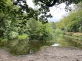
Park Sparrendaal where I took a short break
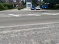
The hashpoint is somewhere on the road here
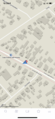
Proof
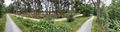
Cycling back through Heidestein


