Difference between revisions of "2021-07-26 50 7"
Gefrierbrand (talk | contribs) (An expedition message sent via Geohash Droid for Android.) |
Gefrierbrand (talk | contribs) m |
||
| (16 intermediate revisions by 2 users not shown) | |||
| Line 1: | Line 1: | ||
| − | + | {{meetup graticule | |
| − | |||
| − | |||
| − | |||
| − | |||
| − | |||
| − | |||
| − | |||
| − | |||
| lat=50 | | lat=50 | ||
| lon=7 | | lon=7 | ||
| date=2021-07-26 | | date=2021-07-26 | ||
| − | }} | + | }} |
__NOTOC__ | __NOTOC__ | ||
== Location == | == Location == | ||
| − | + | In a field near Thür | |
== Participants == | == Participants == | ||
| − | + | *[[User:Gefrierbrand|Gefrierbrand]] | |
| − | + | ||
| + | == Expedition == | ||
| + | After an interesting day with lots of stuff happening, I was glad that the hash was within a reasonable distance and I could use the excuse to go outside on my bike to give my mind some rest. | ||
| − | + | I started in the evening and drove along a few roads I'd taken before, so the initial travel was quite easy. I came along the chapel St. Marcus I knew from my previous [[2021-06-08 50 7|Expedition with Santu]]. Shortly after at some point near Polch, I entered a biketrail which was build upon former railroad tracks, and therefore was really smooth and even. The pleasure of riding there was enhanced even more by the awesome smell of freshly baked cookies in the air. I soon noticed the source: One of the larger european [https://de.wikipedia.org/wiki/Griesson_%E2%80%93_de_Beukelaer pastry producers] has it's factory there. | |
| − | |||
| − | + | The trail led through two interesting tunnels. Even though I've been there before and they were lit inside, it was slightly spooky to drive in there since I was completely alone. No other traffic or pedestrians at all. Immediately afterwards, I drove over the Nette-Viaduct, which provided a nice view. | |
| − | + | ||
| + | Continuing, I came along an adventurepark for children at the edge of Mayen, but unfortunately they had thick bushes all around and I counld't see anything besides the stylized silhouette of a pirate ship at the entrance. | ||
| + | |||
| + | During the expedition, I saw a huge number of combine harvesters driving along the grain fields and producing lots of dust, which together with the strong winds often ended up in my eyes. But this also meant that I might have luck and won't have to carefully squeeze through plants to get to the hashlocation. And indeed I happily noticed that the target was conveniently located in an already harvested field. | ||
| + | |||
| + | I quickly parked my bike at the edge, walked to the location, took obligatory stupid photos and started to head back. As the maps had shown an airfield not far away, I took a different route back home and hoped to be able to get close to some planes, maybe even during takeoff or landing. The entrance of the complex had a barrier which was open, but an ambiguous sign described that entry was only allowed on some conditions. I was unsure if I was allowed in and just turned around. Sadly I didn't see any planes, not even from the outside. | ||
| + | |||
| + | Suddenly, a huge convoy of firefighting vehicles with sirens and blinking lights drove along and right into the airfield complex. I didn't see any fire or smoke so it was probably related to the recent floods in the area. | ||
| + | |||
| + | On the way back I decided I wanted to take a specific road and adjusted my navigation accordingly. This was a mistake. Unbeknownst to me, the area is actively being mined for gravel and other rocks. Usually no problem, but quite often I stood in front of a junction where clearly a road or path once had been, but no longer existed or wasn't traversable. The maps had not been updated accordingly and I often had to turn around or drive in a different direction than anticipated. | ||
| + | |||
| + | But in the end I was able to get to the road I wanted and was rewarded by a really nice view on an interestingly lit old mill. There's just something nice about sodium-vapor lamps inserted in the floor pointing upwards. | ||
== Tracklog == | == Tracklog == | ||
| − | + | {{tracklog | T2021-07-26-20-41gh t.gpx}} | |
== Photos == | == Photos == | ||
| − | |||
| − | |||
| − | |||
<gallery perrow="5"> | <gallery perrow="5"> | ||
| + | Image:2021-07-26_50_7_Gefrierbrand_1627370627090.jpg|Chapel St Markus in Minkelfeld | ||
| + | Image:2021-07-26_50_7_Gefrierbrand_1627370592091.jpg|gooood smell | ||
| + | Image:2021-07-26_50_7_Gefrierbrand_1627370553000.jpg|Nette viadukt (hidden to the left) | ||
| + | Image:2021-07-26_50_7_Gefrierbrand_1627370565964.jpg|spooky tunnel entrance | ||
| + | Image:2021-07-26_50_7_Gefrierbrand_1627373451776.jpg|dusty harvester | ||
| + | Image:2021-07-26_50_7_Gefrierbrand_1627370500077.jpg|hashfield | ||
| + | Image:2021-07-26_50_7_Gefrierbrand_1627370477307.jpg|stupid grin<sup>TM</sup> | ||
| + | Image:2021-07-26_50_7_Gefrierbrand_1627370425472.jpg|thats no road! | ||
| + | Image:2021-07-26_50_7_Gefrierbrand_1627370462340.jpg|birds! | ||
| + | Image:2021-07-26_50_7_Gefrierbrand_1627370403625.jpg|Fancy lighting | ||
| + | Image:2021-07-26_50_7_Gefrierbrand_1627370521860.jpg|proof | ||
</gallery> | </gallery> | ||
== Achievements == | == Achievements == | ||
{{#vardefine:ribbonwidth|800px}} | {{#vardefine:ribbonwidth|800px}} | ||
| − | + | {{land geohash | |
| − | + | | latitude = 50 | |
| − | + | | longitude = 7 | |
| − | + | | date = 2021-07-26 | |
| − | + | | name = Gefrierbrand | |
| − | + | }} | |
| − | + | {{bicycle geohash | |
| − | + | | latitude = 50 | |
| − | + | | longitude = 7 | |
| − | + | | date = 2021-07-26 | |
| − | + | | name = Gefrierbrand | |
| − | -- | + | | distance = 47km |
| − | + | | bothways = true | |
| − | + | }} | |
| − | + | {{Two to the N achievement | |
| − | + | | count = 5 | |
| + | | latitude = 50 | ||
| + | | longitude = 7 | ||
| + | | date = 2021-07-26 | ||
| + | | name = Gefrierbrand | ||
| + | | reached = true | ||
| + | }} | ||
[[Category:Expeditions]] | [[Category:Expeditions]] | ||
| − | |||
[[Category:Expeditions with photos]] | [[Category:Expeditions with photos]] | ||
| − | |||
| − | |||
| − | |||
| − | |||
| − | |||
[[Category:Coordinates reached]] | [[Category:Coordinates reached]] | ||
| − | + | {{location|DE|RP|MYK}} | |
| − | |||
| − | |||
| − | |||
| − | |||
| − | |||
| − | |||
| − | |||
| − | |||
| − | |||
| − | |||
| − | |||
| − | |||
| − | |||
| − | |||
| − | |||
| − | |||
| − | |||
Latest revision as of 08:48, 27 July 2021
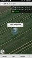
| Mon 26 Jul 2021 in 50,7: 50.3556627, 7.2709638 geohashing.info google osm bing/os kml crox |
Location
In a field near Thür
Participants
Expedition
After an interesting day with lots of stuff happening, I was glad that the hash was within a reasonable distance and I could use the excuse to go outside on my bike to give my mind some rest.
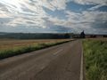
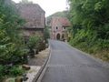
I started in the evening and drove along a few roads I'd taken before, so the initial travel was quite easy. I came along the chapel St. Marcus I knew from my previous Expedition with Santu. Shortly after at some point near Polch, I entered a biketrail which was build upon former railroad tracks, and therefore was really smooth and even. The pleasure of riding there was enhanced even more by the awesome smell of freshly baked cookies in the air. I soon noticed the source: One of the larger european pastry producers has it's factory there.
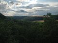
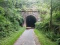
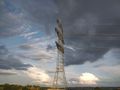
The trail led through two interesting tunnels. Even though I've been there before and they were lit inside, it was slightly spooky to drive in there since I was completely alone. No other traffic or pedestrians at all. Immediately afterwards, I drove over the Nette-Viaduct, which provided a nice view.
Continuing, I came along an adventurepark for children at the edge of Mayen, but unfortunately they had thick bushes all around and I counld't see anything besides the stylized silhouette of a pirate ship at the entrance.
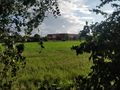
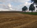
During the expedition, I saw a huge number of combine harvesters driving along the grain fields and producing lots of dust, which together with the strong winds often ended up in my eyes. But this also meant that I might have luck and won't have to carefully squeeze through plants to get to the hashlocation. And indeed I happily noticed that the target was conveniently located in an already harvested field.
I quickly parked my bike at the edge, walked to the location, took obligatory stupid photos and started to head back. As the maps had shown an airfield not far away, I took a different route back home and hoped to be able to get close to some planes, maybe even during takeoff or landing. The entrance of the complex had a barrier which was open, but an ambiguous sign described that entry was only allowed on some conditions. I was unsure if I was allowed in and just turned around. Sadly I didn't see any planes, not even from the outside.
Suddenly, a huge convoy of firefighting vehicles with sirens and blinking lights drove along and right into the airfield complex. I didn't see any fire or smoke so it was probably related to the recent floods in the area.
On the way back I decided I wanted to take a specific road and adjusted my navigation accordingly. This was a mistake. Unbeknownst to me, the area is actively being mined for gravel and other rocks. Usually no problem, but quite often I stood in front of a junction where clearly a road or path once had been, but no longer existed or wasn't traversable. The maps had not been updated accordingly and I often had to turn around or drive in a different direction than anticipated.
But in the end I was able to get to the road I wanted and was rewarded by a really nice view on an interestingly lit old mill. There's just something nice about sodium-vapor lamps inserted in the floor pointing upwards.
Tracklog
Photos
Chapel St Markus in Minkelfeld
gooood smell
Nette viadukt (hidden to the left)
spooky tunnel entrance
dusty harvester
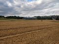
hashfield
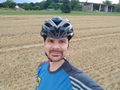
stupid grinTM
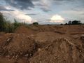
thats no road!
birds!
Fancy lighting
proof


Achievements
Gefrierbrand earned the Land geohash achievement
|
Gefrierbrand earned the Bicycle geohash achievement
|
