Difference between revisions of "2021-08-07 48 7"
(Create expedition) |
(→Achievements: Remove consecutive (current record is 3)) |
||
| (3 intermediate revisions by 2 users not shown) | |||
| Line 11: | Line 11: | ||
== Expedition == | == Expedition == | ||
| + | I had planned to meet with friends to play board games in the afternoon. So no [[Saturday meetup]] for me. | ||
| + | |||
| + | That's my second [[2020-08-17 48 7|expedition to Sigolsheim]]. I decided to take the same route, a small road, parallel to the Eurovelo 5, which goes over the hills and trough the vineyards from Ribeauvillé to Kientzheim. | ||
| + | |||
| + | The coordinates were located on the corner of a street intersection. After recording proof, I though a moment about continuing toward Kaysersberg and its valley. Then I checked the weather app and decided to cycle back home immediately instead. A couple minutes after I left, it started to rain. By the time I arrived home, I was completely soaked. | ||
== Photos == | == Photos == | ||
| + | <gallery> | ||
| + | Image:2021-08-07 48 7 01.jpg | Cycling through the vineyards | ||
| + | Image:2021-08-07 48 7 02.jpg | In Kientzheim | ||
| + | Image:2021-08-07 48 7 03.png | Coordinates reached | ||
| + | Image:2021-08-07 48 7 04.jpg | My bicycle at the geohash | ||
| + | Image:2021-08-07 48 7 05.jpg | Stupid grin | ||
| + | Image:2021-08-07 48 7 06.jpg | Surroundings | ||
| + | </gallery> | ||
== Achievements == | == Achievements == | ||
| Line 27: | Line 40: | ||
| date = 2021-08-07 | | date = 2021-08-07 | ||
| name = [[User:Baarde|Baarde]] | | name = [[User:Baarde|Baarde]] | ||
| − | | distance = | + | | distance = 47 km |
| − | + | | bothways = true | |
| − | |||
| − | |||
| − | |||
| − | |||
| − | |||
| − | | | ||
}} | }} | ||
__NOTOC__ | __NOTOC__ | ||
[[Category:Expeditions]] | [[Category:Expeditions]] | ||
| + | [[Category:Expeditions with photos]] | ||
| + | [[Category:Coordinates reached]] | ||
| + | {{location|FR|68}} | ||
Latest revision as of 08:29, 13 April 2023
| Sat 7 Aug 2021 in 48,7: 48.1341998, 7.3014583 geohashing.info google osm bing/os kml crox |
Location
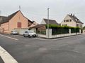
At a street intersection, in Sigolsheim.
Participants
Expedition
I had planned to meet with friends to play board games in the afternoon. So no Saturday meetup for me.
That's my second expedition to Sigolsheim. I decided to take the same route, a small road, parallel to the Eurovelo 5, which goes over the hills and trough the vineyards from Ribeauvillé to Kientzheim.
The coordinates were located on the corner of a street intersection. After recording proof, I though a moment about continuing toward Kaysersberg and its valley. Then I checked the weather app and decided to cycle back home immediately instead. A couple minutes after I left, it started to rain. By the time I arrived home, I was completely soaked.
Photos
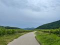
Cycling through the vineyards
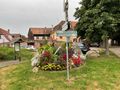
In Kientzheim
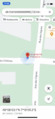
Coordinates reached
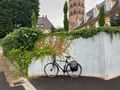
My bicycle at the geohash

Stupid grin
Surroundings


Achievements
Baarde earned the Land geohash achievement
|
Baarde earned the Bicycle geohash achievement
|