Difference between revisions of "2021-08-07 52 5"
m (Location) |
|||
| Line 10: | Line 10: | ||
== Participants == | == Participants == | ||
[[User:FelixTheCat|FelixTheCat]] ([[User talk:FelixTheCat|talk]]) | [[User:FelixTheCat|FelixTheCat]] ([[User talk:FelixTheCat|talk]]) | ||
| + | |||
| + | [[User:xnyhps|xnyhps]] ([[User talk:xnyhps|talk]]) | ||
== Expedition == | == Expedition == | ||
| + | === FelixTheCat === | ||
The past few months have not yielded any doable geohashes around here, so I was happy to see that today's was in a well-accessible spot in a forest. I left home around 08:30 and arrived at a small car park at the forest's entrance about an hour later. The forest is officially a military training area, but no-one was there on a Saturday morning in August. I walked through the forest for about 10 minutes and found the hash just a little off the footpath. After taking the required pictures I further explored the forest and the surrounding area. Afterwards I vitited a museum in Bunnik about the [https://en.wikipedia.org/wiki/Dutch_Water_Line#New_Dutch_Waterline New Dutch Water Line], which was recently added to the World Heritage List. After that I went home again. | The past few months have not yielded any doable geohashes around here, so I was happy to see that today's was in a well-accessible spot in a forest. I left home around 08:30 and arrived at a small car park at the forest's entrance about an hour later. The forest is officially a military training area, but no-one was there on a Saturday morning in August. I walked through the forest for about 10 minutes and found the hash just a little off the footpath. After taking the required pictures I further explored the forest and the surrounding area. Afterwards I vitited a museum in Bunnik about the [https://en.wikipedia.org/wiki/Dutch_Water_Line#New_Dutch_Waterline New Dutch Water Line], which was recently added to the World Heritage List. After that I went home again. | ||
| + | |||
| + | === xnyhps === | ||
| + | Unaware of FelixTheCat's plans, I also visited the geohash. I was already planning a cycling trip anyway, so it seemed a short detour to visit the hash. I cycled to Den Dolder and then through De Paltz, which is apparently open for cyclists during the day. I locked my bike to a tree in the car park and went towards the hash at around 16:30. It took a bit of time to find the right place (I think there are some inconsistencies with foot paths on OSM), but eventually I found it. Just like in the morning, late on a Saturday afternoon there was no-one else around either. On the way back, I think I may have spotted a fox? | ||
== Photos == | == Photos == | ||
| + | === FelixTheCat === | ||
<gallery perrow="5"> | <gallery perrow="5"> | ||
Image:2021-08-07 52 5 FelixTheCat 1.JPG | The entrance to the forest. | Image:2021-08-07 52 5 FelixTheCat 1.JPG | The entrance to the forest. | ||
| Line 27: | Line 34: | ||
Image:2021-08-07 52 5 FelixTheCat 10.JPG | Over near Bunnik, there's a museum dedicated to the New Dutch Water Line. One of the exhibits is a model where you can try inundating certain areas to see what happens. | Image:2021-08-07 52 5 FelixTheCat 10.JPG | Over near Bunnik, there's a museum dedicated to the New Dutch Water Line. One of the exhibits is a model where you can try inundating certain areas to see what happens. | ||
</gallery> | </gallery> | ||
| + | |||
| + | === xnyhps === | ||
== Achievements == | == Achievements == | ||
| Line 35: | Line 44: | ||
| date = 2021-08-07 | | date = 2021-08-07 | ||
| name = [[User:FelixTheCat|FelixTheCat]] ([[User talk:FelixTheCat|talk]]) | | name = [[User:FelixTheCat|FelixTheCat]] ([[User talk:FelixTheCat|talk]]) | ||
| + | }} | ||
| + | {{land geohash | ||
| + | | latitude = 52 | ||
| + | | longitude = 5 | ||
| + | | date = 2021-08-07 | ||
| + | | name = [[User:xnyhps|xnyhps]] ([[User talk:xnyhps|talk]]) | ||
}} | }} | ||
Revision as of 07:04, 11 August 2021
| Sat 7 Aug 2021 in 52,5: 52.1341998, 5.3014583 geohashing.info google osm bing/os kml crox |
Location
In a forest near Soesterberg, Utrecht province.
Participants
Expedition
FelixTheCat
The past few months have not yielded any doable geohashes around here, so I was happy to see that today's was in a well-accessible spot in a forest. I left home around 08:30 and arrived at a small car park at the forest's entrance about an hour later. The forest is officially a military training area, but no-one was there on a Saturday morning in August. I walked through the forest for about 10 minutes and found the hash just a little off the footpath. After taking the required pictures I further explored the forest and the surrounding area. Afterwards I vitited a museum in Bunnik about the New Dutch Water Line, which was recently added to the World Heritage List. After that I went home again.
xnyhps
Unaware of FelixTheCat's plans, I also visited the geohash. I was already planning a cycling trip anyway, so it seemed a short detour to visit the hash. I cycled to Den Dolder and then through De Paltz, which is apparently open for cyclists during the day. I locked my bike to a tree in the car park and went towards the hash at around 16:30. It took a bit of time to find the right place (I think there are some inconsistencies with foot paths on OSM), but eventually I found it. Just like in the morning, late on a Saturday afternoon there was no-one else around either. On the way back, I think I may have spotted a fox?
Photos
FelixTheCat
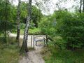
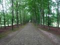
The entrance to the forest.
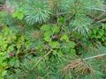
There are ripe blackberries everywhere. I kept stuffing my face with these throughout the expedition.
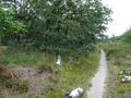
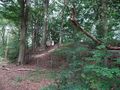
The path near the hash.
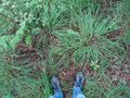
My feet at the exact spot.
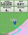
GPS proof.
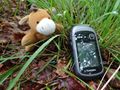
Lloyd posing, with a hash-beetle.
A bit further on is this hilltop called Stompert (51 metres, one of the tallest peaks of the Utrecht Hill Ridge). There's a little cabin at the top. I'm not sure what it does; it's surrounded by a fence.
On the other side of the main road is an old country estate named "Paltz". This is the rather grand main road.
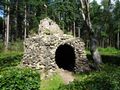
There's a folly named "Hermit's Cave" inside a maze.
Over near Bunnik, there's a museum dedicated to the New Dutch Water Line. One of the exhibits is a model where you can try inundating certain areas to see what happens.


xnyhps
Achievements
FelixTheCat (talk) earned the Land geohash achievement
|
xnyhps (talk) earned the Land geohash achievement
|