Difference between revisions of "2021-08-23 47 -122"
(Queen Anne this afternoon) |
Coyotebush (talk | contribs) |
||
| (15 intermediate revisions by 3 users not shown) | |||
| Line 13: | Line 13: | ||
== Participants == | == Participants == | ||
* [[User:Thomcat|Thomcat]] | * [[User:Thomcat|Thomcat]] | ||
| + | * [[User:Coyotebush|Coyotebush]] ([[User talk:Coyotebush|talk]]) | ||
| + | * [[User:Zebburkeconte|Zebburkeconte]] | ||
== Plans == | == Plans == | ||
Late afternoon, after work - time flexible | Late afternoon, after work - time flexible | ||
| + | * Same. 5:30 is the earliest I can plan on. [[User:Coyotebush|Coyotebush]] ([[User talk:Coyotebush|talk]]) 16:26, 23 August 2021 (UTC) | ||
| + | ::5:30 it is. --[[User:Thomcat|Thomcat]] ([[User talk:Thomcat|talk]]) 19:13, 23 August 2021 (UTC) | ||
== Expedition == | == Expedition == | ||
| − | + | ||
| + | ===Zebburkeconte=== | ||
| + | |||
| + | Not able to be there at 5:30 but happy to have reached my first geohash in a few years! | ||
| + | |||
| + | ===Thomcat=== | ||
| + | I parked across the street. GPS had some difficulties with fix, and it seemed the closer I got to the eye clinic, the further across the street it wanted to put me. Maybe I just need better glasses? | ||
| + | |||
| + | The satellite photo is pretty grainy, but shows the hashpoint as between the two trees at the curb. I chalked the nearby wall - marks on vertical surfaces last a little longer, though we haven't had serious rain in a while. | ||
| + | |||
| + | Meetup and expedition success, coordinates definitely reached - even if the devices were loathe to show it. | ||
| + | |||
| + | ===coyotebush=== | ||
| + | |||
| + | Got briefly confused biking through the neighborhood and rolled up to Thomcat a couple minutes after 5:30. My GPS readings from the curb were well within error. I soon headed home via the scenic trail along the bay. | ||
| + | |||
| + | *Close enough! -- [[User:Coyotebush|Coyotebush]] ([[User talk:Coyotebush|talk]]) [https://openstreetmap.org/?mlat=47.62433190&mlon=-122.36198840&zoom=16 @47.6243,-122.3620] 17:36, 23 August 2021 (PDT) | ||
== Tracklog == | == Tracklog == | ||
| Line 27: | Line 47: | ||
Image:2012-##-## ## ## Alpha.jpg | Witty Comment | Image:2012-##-## ## ## Alpha.jpg | Witty Comment | ||
--> | --> | ||
| + | Zebburkeconte | ||
<gallery perrow="5"> | <gallery perrow="5"> | ||
| + | |||
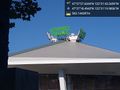
| + | Image:2021-08-23_47_-122_Zebburkeconte_1629750753798.jpg|Haven't gone to a geohash in ages. I just installed the GeoHashDroid app yesterday, so this one seemed like destiny! Finally a Walk Geohash, as well. [https://openstreetmap.org/?mlat=47.62430480&mlon=-122.36196410&zoom=16 @47.6243,-122.3620] | ||
| + | |||
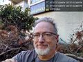
| + | Image:2021-08-23_47_-122_Zebburkeconte_1629751597666.jpg|Stupid grin, possibly rotated incorrectly. | ||
| + | |||
| + | Image:2021-08-23_47_-122_Zebburkeconte_1629751654271.jpg|The hashpoint itself. | ||
| + | |||
| + | Image:2021-08-23_47_-122_thomcat_1629763143000.jpg|Climate Pledge [https://openstreetmap.org/?mlat=47.62180397&mlon=-122.35555100&zoom=16 @47.6218,-122.3556] | ||
| + | |||
| + | Image:2021-08-23_47_-122_thomcat_1629763500000.jpg|Bay viee [https://openstreetmap.org/?mlat=47.62433950&mlon=-122.36190610&zoom=16 @47.6243,-122.3619] | ||
| + | |||
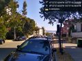
| + | Image:2021-08-23_47_-122_thomcat_1629763692000.jpg|Geohasher [https://openstreetmap.org/?mlat=47.62434240&mlon=-122.36196680&zoom=16 @47.6243,-122.3620] | ||
| + | |||
| + | Image:2021-08-23_47_-122_coyotebush_1629765550627.jpg|The map | ||
| + | |||
| + | Image:2021-08-23_47_-122_coyotebush_1629765603000.jpg|Bike and chalk | ||
</gallery> | </gallery> | ||
| Line 33: | Line 70: | ||
{{#vardefine:ribbonwidth|800px}} | {{#vardefine:ribbonwidth|800px}} | ||
<!-- Add any achievement ribbons you earned below, or remove this section --> | <!-- Add any achievement ribbons you earned below, or remove this section --> | ||
| − | + | {{Bicycle geohash | latitude = 47 | longitude = -122 | date = 2021-08-23 | name = coyotebush }} | |
| − | {{ | ||
| − | | latitude = 47 | ||
| − | | longitude = -122 | ||
| − | | date = | ||
| − | |||
| − | | name = | ||
| − | |||
| − | }} | ||
| − | |||
| − | |||
| − | |||
| − | |||
[[Category:Expeditions]] | [[Category:Expeditions]] | ||
[[Category:Expeditions with photos]] | [[Category:Expeditions with photos]] | ||
[[Category:Coordinates reached]] | [[Category:Coordinates reached]] | ||
| − | |||
| − | |||
| − | |||
| − | |||
| − | |||
| − | |||
| − | |||
| − | |||
| − | |||
| − | |||
{{location|US|WA|KN}} | {{location|US|WA|KN}} | ||
Latest revision as of 21:48, 29 August 2021
| Mon 23 Aug 2021 in Seattle: 47.6243429, -122.3620183 geohashing.info google osm bing/os kml crox |
Location
Curbside geohash outside Queen Anne Vision Clinic
Participants
Plans
Late afternoon, after work - time flexible
- Same. 5:30 is the earliest I can plan on. Coyotebush (talk) 16:26, 23 August 2021 (UTC)
Expedition
Zebburkeconte
Not able to be there at 5:30 but happy to have reached my first geohash in a few years!
Thomcat
I parked across the street. GPS had some difficulties with fix, and it seemed the closer I got to the eye clinic, the further across the street it wanted to put me. Maybe I just need better glasses?
The satellite photo is pretty grainy, but shows the hashpoint as between the two trees at the curb. I chalked the nearby wall - marks on vertical surfaces last a little longer, though we haven't had serious rain in a while.
Meetup and expedition success, coordinates definitely reached - even if the devices were loathe to show it.
coyotebush
Got briefly confused biking through the neighborhood and rolled up to Thomcat a couple minutes after 5:30. My GPS readings from the curb were well within error. I soon headed home via the scenic trail along the bay.
- Close enough! -- Coyotebush (talk) @47.6243,-122.3620 17:36, 23 August 2021 (PDT)
Tracklog
Photos
Zebburkeconte
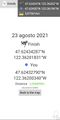
Haven't gone to a geohash in ages. I just installed the GeoHashDroid app yesterday, so this one seemed like destiny! Finally a Walk Geohash, as well. @47.6243,-122.3620
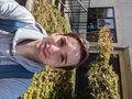
Stupid grin, possibly rotated incorrectly.
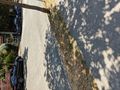
The hashpoint itself.
Climate Pledge @47.6218,-122.3556
Bay viee @47.6243,-122.3619
Geohasher @47.6243,-122.3620
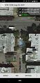
The map
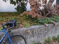
Bike and chalk


Achievements
coyotebush earned the Bicycle geohash achievement
|