Difference between revisions of "2021-09-17 50 7"
Gefrierbrand (talk | contribs) ([retro picture]StupidGrin) |
Gefrierbrand (talk | contribs) |
||
| (7 intermediate revisions by 4 users not shown) | |||
| Line 1: | Line 1: | ||
| − | + | {{meetup graticule | |
| − | |||
| − | |||
| − | |||
| − | |||
| − | |||
| − | |||
| − | |||
| − | |||
| lat=50 | | lat=50 | ||
| lon=7 | | lon=7 | ||
| date=2021-09-17 | | date=2021-09-17 | ||
| − | }} | + | }} |
__NOTOC__ | __NOTOC__ | ||
== Location == | == Location == | ||
| − | + | The hash was located right next to a path above the Moselle. | |
== Participants == | == Participants == | ||
| − | + | *[[User:Santu|Santu]] | |
| − | + | *[[User:Gefrierbrand|Gefrierbrand]] | |
| + | *Pedro the dog | ||
== Plans == | == Plans == | ||
| − | + | After a short discussion about whether to approach from south or north, we decided to go for the latter. This way we hadn't to walk along the main road and were sure to find a good parking place. | |
== Expedition == | == Expedition == | ||
| − | + | Being in the situation to need an honest work to make a living, we could start only around an hour after sunset. Luckily we brought not only a "Leuchti" for Pedro but also a flashlight (and an UV-flashlight, which was of no great use at all but kept Gefrierbrand busy to search the area for mysterious glowing items). | |
| − | + | Parking went as planned and we reached the Carolaturm as intermediate station without any issues. At this point the darkness was only a small inconvenience to Santu. Going on we came to an open field with some trees but a great view on the very bright moon. We occasionally checked the map but were distracted by a) peeing against trees, b) examining botanicals, and c) feeling more and more discomfort due to the darkness (guess who did what). So the inevitable happened: we lost our track and had to reverse. But it was only a few hundred meters and the right track was rather pleasing to walk on and in daylight would have provided a beautiful look over the river and across to Winningen. | |
| − | + | ||
| + | After a while we came to the point where we had to leave the track to reach the hash location. As it was rather steep terrain and covered with slippery plates of slade, we decided to leave Pedro at the track. Not because he wasn't able to handle the underground but because we feared he might get us in a precarious situation with his enthusiastic personality while we struggled to stay upright on our feet. This also had the advantage that he stood there like a light house so we could easily find our way back to the track after climbing up from the hash again. The point itself was about 20m off the path and right before we had to enter the shrubbery. | ||
| + | |||
| + | On the way back Santu felt less and less relaxed. Putting the flashlight to full power at 225 lumen and having Gefrierbrand with Pedro covering her back helped a bit, but reaching the street lights was quite a relief. | ||
== Photos == | == Photos == | ||
| − | < | + | <gallery perrow="4"> |
| − | Image: | + | Image:2021-09-17 50-7 Moon.JPG|Bright moon above us |
| − | -- | + | Image:2021-09-17 50-7 Carolaturm.JPG|Nice little building "Carolaturm" |
| − | + | Image:2021-09-17 50-7 Proof.jpg|Proof | |
| − | + | Image:2021-09-17_50_7_Gefrierbrand_1631909113000.jpg|StupidGrin<sup>TM</sup> which took some effort for Santu | |
| − | Image:2021-09-17_50_7_Gefrierbrand_1631909113000.jpg|StupidGrin | ||
</gallery> | </gallery> | ||
== Achievements == | == Achievements == | ||
{{#vardefine:ribbonwidth|800px}} | {{#vardefine:ribbonwidth|800px}} | ||
| − | + | {{land geohash | |
| − | + | | latitude = 50 | |
| − | + | | longitude = 7 | |
| − | + | | date = 2021-09-17 | |
| − | + | | name = Santu & Gefrierbrand | |
| − | + | }} | |
| − | |||
| − | |||
| − | |||
| − | |||
| − | |||
| − | |||
| − | |||
| − | |||
| − | <!-- | + | <!-- =============== USEFUL CATEGORIES FOLLOW ================ --> |
[[Category:Expeditions]] | [[Category:Expeditions]] | ||
| − | |||
[[Category:Expeditions with photos]] | [[Category:Expeditions with photos]] | ||
| − | |||
| − | |||
| − | |||
| − | |||
| − | |||
[[Category:Coordinates reached]] | [[Category:Coordinates reached]] | ||
| − | + | [[Category:Expeditions with dogs]] | |
| − | + | {{location|DE|RP|KO}} | |
| − | |||
| − | |||
| − | |||
| − | |||
| − | |||
| − | |||
| − | |||
| − | |||
| − | |||
| − | |||
| − | [[Category: | ||
| − | |||
| − | |||
| − | |||
| − | |||
| − | |||
Latest revision as of 07:56, 18 October 2022
| Fri 17 Sep 2021 in 50,7: 50.3052358, 7.5194771 geohashing.info google osm bing/os kml crox |
Location
The hash was located right next to a path above the Moselle.
Participants
- Santu
- Gefrierbrand
- Pedro the dog
Plans
After a short discussion about whether to approach from south or north, we decided to go for the latter. This way we hadn't to walk along the main road and were sure to find a good parking place.
Expedition
Being in the situation to need an honest work to make a living, we could start only around an hour after sunset. Luckily we brought not only a "Leuchti" for Pedro but also a flashlight (and an UV-flashlight, which was of no great use at all but kept Gefrierbrand busy to search the area for mysterious glowing items).
Parking went as planned and we reached the Carolaturm as intermediate station without any issues. At this point the darkness was only a small inconvenience to Santu. Going on we came to an open field with some trees but a great view on the very bright moon. We occasionally checked the map but were distracted by a) peeing against trees, b) examining botanicals, and c) feeling more and more discomfort due to the darkness (guess who did what). So the inevitable happened: we lost our track and had to reverse. But it was only a few hundred meters and the right track was rather pleasing to walk on and in daylight would have provided a beautiful look over the river and across to Winningen.
After a while we came to the point where we had to leave the track to reach the hash location. As it was rather steep terrain and covered with slippery plates of slade, we decided to leave Pedro at the track. Not because he wasn't able to handle the underground but because we feared he might get us in a precarious situation with his enthusiastic personality while we struggled to stay upright on our feet. This also had the advantage that he stood there like a light house so we could easily find our way back to the track after climbing up from the hash again. The point itself was about 20m off the path and right before we had to enter the shrubbery.
On the way back Santu felt less and less relaxed. Putting the flashlight to full power at 225 lumen and having Gefrierbrand with Pedro covering her back helped a bit, but reaching the street lights was quite a relief.
Photos
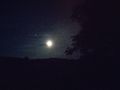
Bright moon above us
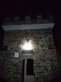
Nice little building "Carolaturm"
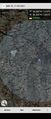
Proof
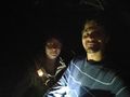
StupidGrinTM which took some effort for Santu


Achievements
Santu & Gefrierbrand earned the Land geohash achievement
|