Difference between revisions of "2021-09-18 50 7"
Gefrierbrand (talk | contribs) ([live] Finally a Water-Geohash possibility on the Mosel.) |
Gefrierbrand (talk | contribs) |
||
| (7 intermediate revisions by 3 users not shown) | |||
| Line 1: | Line 1: | ||
| − | + | {{meetup graticule | |
| − | |||
| − | |||
| − | |||
| − | |||
| − | |||
| − | |||
| − | |||
| − | |||
| lat=50 | | lat=50 | ||
| lon=7 | | lon=7 | ||
| date=2021-09-18 | | date=2021-09-18 | ||
| − | }} | + | }}__NOTOC__ |
| − | __NOTOC__ | ||
== Location == | == Location == | ||
| − | + | On the river Moselle between Reil and Burg | |
== Participants == | == Participants == | ||
| − | + | *[[User:Gefrierbrand|Gefrierbrand]] | |
| − | + | *[[User:Santu|Santu]] | |
| + | *Pedro the dog | ||
== Plans == | == Plans == | ||
| − | + | Drive south along the Moselle, find a parking spot near the water, inflate the kayak and make the rest up along the way. | |
== Expedition == | == Expedition == | ||
| − | + | We noticed the hashlocation was right in the middle of the river Moselle and spontaneously decided to try to reach it. The weather was great and it was not too far from home so it was a nice opportunity for a weekend expedition. | |
| + | Gefrierbrand had previous experience rowing on the river and roughly knew how to approach it best, but Pedro is relatively water shy (strange for a dog but he's special) and never has been on a boat before, so we took his live-west along just to be safe. | ||
| + | |||
| + | Reaching the general area was no problem at all and we had a nice drive along the beautiful vineyards in the Moselle valleys. We found a parking spot about 1,5 km downstream of the hash and prepared our boat there. Pedro was initially unsure of the general situation, but behaved very bravely and made no fuss at all once in the boat so we could start rowing. | ||
| + | |||
| + | Thankfully the river flows relatively slowly and while keeping at the sides near the shore we were able to make progress against the current reaching about 3 km/h. Since we weren't sure whether we could row against the stream in the middle of the river, we decided to go a bit further than needed at the shore and then turn inwards and float back. | ||
| + | |||
| + | Just as we started to go in the middle of the river, a huge passenger ship appeared a few hundred meters away around a corner and we needed to hurry a bit. But we were able to reach the point before it arrived and quickly returned to the shore to not be in it's way. | ||
| + | On our way back it was obviously way easier to row. We found a shallow area which was ideal for swimming, so we affixed the boat to a tree and splashed around in the water, which was quite cold, but refreshing. Pedro also waded into it trying to rescue us, but did not go deeper than to his belly. We're still not sure if he even can swim. | ||
| − | + | Once we returned to the shore we continued to explore the area by car and headed to the nearby Marienburg and the "Prinzenkopfturm" lookout tower where we had an awesome view over one of the many sharp turns of the river. We then went to Cochem and visited the town center (lots of people there!) and finally ate something (we skipped lunch earlier). Obviously we had to walk up to the gorgeous Reichsburg before returning home again. | |
| − | |||
| − | |||
== Photos == | == Photos == | ||
| − | |||
| − | |||
| − | |||
<gallery perrow="5"> | <gallery perrow="5"> | ||
| + | File:2021-09-18 50-7 Boat2.jpg|Brave dog and man | ||
| + | File:2021-09-18 50-7 Grin.jpeg|StupidGrin<sup>TM</sup> | ||
| + | File:2021-09-18 50-7 Moselle.JPG|Looping Moselle | ||
| + | File:2021-09-18 50-7 Reichsburg1.jpg|Reichsburg in Cochem | ||
| + | File:2021-09-18 50-7 Proof.jpg|Proof | ||
</gallery> | </gallery> | ||
== Achievements == | == Achievements == | ||
{{#vardefine:ribbonwidth|800px}} | {{#vardefine:ribbonwidth|800px}} | ||
| − | + | {{water geohash | |
| − | + | | latitude = 50 | |
| − | + | | longitude = 7 | |
| − | + | | date = 2021-09-17 | |
| − | + | | name = Gefrierbrand & Santu | |
| − | + | | vehicle = inflatable kayak | |
| − | + | }} | |
| − | |||
| − | |||
| − | |||
| − | |||
| − | |||
| − | |||
| − | |||
| − | |||
| − | |||
[[Category:Expeditions]] | [[Category:Expeditions]] | ||
| − | |||
[[Category:Expeditions with photos]] | [[Category:Expeditions with photos]] | ||
| − | |||
| − | |||
| − | |||
| − | |||
| − | |||
[[Category:Coordinates reached]] | [[Category:Coordinates reached]] | ||
| − | + | [[Category:Expeditions with dogs]] | |
| − | + | {{location|DE|RP|BKS}} | |
| − | |||
| − | |||
| − | |||
| − | |||
| − | |||
| − | |||
| − | |||
| − | |||
| − | |||
| − | |||
| − | [[Category: | ||
| − | |||
| − | |||
| − | |||
| − | |||
| − | |||
Latest revision as of 07:57, 18 October 2022
| Sat 18 Sep 2021 in 50,7: 50.0125316, 7.1221371 geohashing.info google osm bing/os kml crox |
Location
On the river Moselle between Reil and Burg
Participants
- Gefrierbrand
- Santu
- Pedro the dog
Plans
Drive south along the Moselle, find a parking spot near the water, inflate the kayak and make the rest up along the way.
Expedition
We noticed the hashlocation was right in the middle of the river Moselle and spontaneously decided to try to reach it. The weather was great and it was not too far from home so it was a nice opportunity for a weekend expedition. Gefrierbrand had previous experience rowing on the river and roughly knew how to approach it best, but Pedro is relatively water shy (strange for a dog but he's special) and never has been on a boat before, so we took his live-west along just to be safe.
Reaching the general area was no problem at all and we had a nice drive along the beautiful vineyards in the Moselle valleys. We found a parking spot about 1,5 km downstream of the hash and prepared our boat there. Pedro was initially unsure of the general situation, but behaved very bravely and made no fuss at all once in the boat so we could start rowing.
Thankfully the river flows relatively slowly and while keeping at the sides near the shore we were able to make progress against the current reaching about 3 km/h. Since we weren't sure whether we could row against the stream in the middle of the river, we decided to go a bit further than needed at the shore and then turn inwards and float back.
Just as we started to go in the middle of the river, a huge passenger ship appeared a few hundred meters away around a corner and we needed to hurry a bit. But we were able to reach the point before it arrived and quickly returned to the shore to not be in it's way.
On our way back it was obviously way easier to row. We found a shallow area which was ideal for swimming, so we affixed the boat to a tree and splashed around in the water, which was quite cold, but refreshing. Pedro also waded into it trying to rescue us, but did not go deeper than to his belly. We're still not sure if he even can swim.
Once we returned to the shore we continued to explore the area by car and headed to the nearby Marienburg and the "Prinzenkopfturm" lookout tower where we had an awesome view over one of the many sharp turns of the river. We then went to Cochem and visited the town center (lots of people there!) and finally ate something (we skipped lunch earlier). Obviously we had to walk up to the gorgeous Reichsburg before returning home again.
Photos
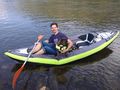
Brave dog and man
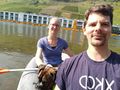
StupidGrinTM
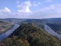
Looping Moselle
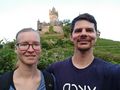
Reichsburg in Cochem

Proof


Achievements
Gefrierbrand & Santu earned the Water geohash achievement
|