Difference between revisions of "2021-10-09 51 4"
FelixTheCat (talk | contribs) (Created page with "{{subst:Expedition |lat = 51 |lon = 4 |date = 2021-10-09 }}") |
m (Location) |
||
| (One intermediate revision by one other user not shown) | |||
| Line 1: | Line 1: | ||
| − | + | {{meetup graticule | |
| − | |||
| − | |||
| − | |||
| − | |||
| − | |||
| − | |||
| − | |||
| − | |||
| lat=51 | | lat=51 | ||
| lon=4 | | lon=4 | ||
| date=2021-10-09 | | date=2021-10-09 | ||
| − | }} | + | }} |
__NOTOC__ | __NOTOC__ | ||
== Location == | == Location == | ||
| − | + | In a park in Halsteren, North Brabant province. | |
== Participants == | == Participants == | ||
| − | + | [[User:FelixTheCat|FelixTheCat]] ([[User talk:FelixTheCat|talk]]) | |
| − | |||
| − | |||
| − | |||
| − | |||
== Expedition == | == Expedition == | ||
| − | + | Today's hash seemed to be in a park in Halsteren, which is a town right next to Bergen op Zoom, the main settlement in western Brabant. I took the hashmobile there and parked behind the swimming pool. The point was on a field that seemed to have had some kind of vegetation there that had recently been cut down. I'm not sure what it was; maybe it was just overgrown with weeds. The point was easy to find, and I reached zero distance on the GPS almost right away. The weather was nice: cool, but sunny and dry. There were lots of people walking their dogs in the park; I think I was the only one without a dog, and I was definitely the only one with a horse and a rat. | |
| − | + | After taking some pictures I walked around the park a bit more. Then I went to have a look at nearby [https://en.wikipedia.org/wiki/Fort_de_Roovere Fort de Roovere] and its world-famous Moses Bridge. There were quite a few people with fancy cameras walking around the fort; I think they belonged to a photography club. Afterwards I went for a drive along the Oesterdam (part of the [https://en.wikipedia.org/wiki/Delta_Works Delta Works]), then toured the island of [https://en.wikipedia.org/wiki/Tholen Tholen] and visited the local museum in [https://en.wikipedia.org/wiki/Sint-Annaland Sint Annaland]. | |
| − | |||
== Photos == | == Photos == | ||
| − | |||
| − | |||
| − | |||
<gallery perrow="5"> | <gallery perrow="5"> | ||
| + | Image:2021-10-09 51 4 FelixTheCat 1.JPG | The entrance to the park. | ||
| + | Image:2021-10-09 51 4 FelixTheCat 2.JPG | Right around the corner we find the hash field. | ||
| + | Image:2021-10-09 51 4 FelixTheCat 3.png | And then we find the hash. | ||
| + | Image:2021-10-09 51 4 FelixTheCat 4.JPG | Lloyd and Templeton celebrating. | ||
| + | Image:2021-10-09 51 4 FelixTheCat 5.JPG | Looking west. | ||
| + | Image:2021-10-09 51 4 FelixTheCat 6.JPG | Looking north. | ||
| + | Image:2021-10-09 51 4 FelixTheCat 7.JPG | Looking east. | ||
| + | Image:2021-10-09 51 4 FelixTheCat 8.JPG | Looking south. | ||
| + | Image:2021-10-09 51 4 FelixTheCat 9.JPG | There's an observation tower at Fort de Roovere. This the the view from the top. Note Moses bridge on the left. | ||
| + | Image:2021-10-09 51 4 FelixTheCat 10.JPG | This is the bridge up close. It gives you the idea that you're parting the waters like Moses did. | ||
</gallery> | </gallery> | ||
== Achievements == | == Achievements == | ||
{{#vardefine:ribbonwidth|800px}} | {{#vardefine:ribbonwidth|800px}} | ||
| − | + | {{land geohash | |
| − | + | | latitude = 51 | |
| − | + | | longitude = 4 | |
| − | + | | date = 2021-10-09 | |
| − | + | | name = [[User:FelixTheCat|FelixTheCat]] ([[User talk:FelixTheCat|talk]]) | |
| − | + | }} | |
| − | |||
| − | |||
| − | |||
| − | |||
| − | |||
| − | |||
| − | |||
| − | |||
| − | |||
| − | |||
[[Category:Expeditions]] | [[Category:Expeditions]] | ||
| − | |||
[[Category:Expeditions with photos]] | [[Category:Expeditions with photos]] | ||
| − | |||
| − | |||
| − | |||
| − | |||
| − | |||
[[Category:Coordinates reached]] | [[Category:Coordinates reached]] | ||
| − | + | {{location|NL|NB}} | |
| − | |||
| − | |||
| − | |||
| − | |||
| − | |||
| − | |||
| − | |||
| − | |||
| − | |||
| − | |||
| − | |||
| − | |||
| − | |||
| − | |||
| − | |||
| − | |||
| − | |||
Latest revision as of 15:42, 9 October 2021
| Sat 9 Oct 2021 in 51,4: 51.5224457, 4.2889687 geohashing.info google osm bing/os kml crox |
Location
In a park in Halsteren, North Brabant province.
Participants
Expedition
Today's hash seemed to be in a park in Halsteren, which is a town right next to Bergen op Zoom, the main settlement in western Brabant. I took the hashmobile there and parked behind the swimming pool. The point was on a field that seemed to have had some kind of vegetation there that had recently been cut down. I'm not sure what it was; maybe it was just overgrown with weeds. The point was easy to find, and I reached zero distance on the GPS almost right away. The weather was nice: cool, but sunny and dry. There were lots of people walking their dogs in the park; I think I was the only one without a dog, and I was definitely the only one with a horse and a rat.
After taking some pictures I walked around the park a bit more. Then I went to have a look at nearby Fort de Roovere and its world-famous Moses Bridge. There were quite a few people with fancy cameras walking around the fort; I think they belonged to a photography club. Afterwards I went for a drive along the Oesterdam (part of the Delta Works), then toured the island of Tholen and visited the local museum in Sint Annaland.
Photos
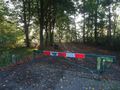
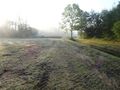
The entrance to the park.
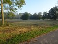
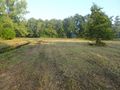
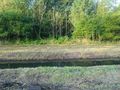
Right around the corner we find the hash field.
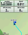
And then we find the hash.
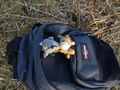
Lloyd and Templeton celebrating.
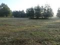
Looking west.
Looking north.
Looking east.
Looking south.
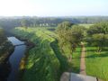
There's an observation tower at Fort de Roovere. This the the view from the top. Note Moses bridge on the left.
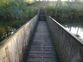
This is the bridge up close. It gives you the idea that you're parting the waters like Moses did.


Achievements
FelixTheCat (talk) earned the Land geohash achievement
|