Difference between revisions of "2021-10-15 52 4"
FelixTheCat (talk | contribs) (Created page with "{{subst:Expedition |lat = 52 |lon = 4 |date = 2021-10-15 }}") |
m (Location) |
||
| (One intermediate revision by one other user not shown) | |||
| Line 1: | Line 1: | ||
| − | + | {{meetup graticule | |
| − | |||
| − | |||
| − | |||
| − | |||
| − | |||
| − | |||
| − | |||
| − | |||
| lat=52 | | lat=52 | ||
| lon=4 | | lon=4 | ||
| date=2021-10-15 | | date=2021-10-15 | ||
| − | }} | + | }} |
__NOTOC__ | __NOTOC__ | ||
== Location == | == Location == | ||
| − | + | Sint Martinuslaan in Voorburg, South Holland province. | |
== Participants == | == Participants == | ||
| − | + | [[User:FelixTheCat|FelixTheCat]] ([[User talk:FelixTheCat|talk]]) | |
| − | |||
| − | |||
| − | |||
| − | |||
== Expedition == | == Expedition == | ||
| − | + | Today's hash was in a residential area in Voorburg. The exact point was about 6 km as the crow flies from my workplace, so I decided to go there on my bike after work. Our last meeting of the week finished at about 17:10 and I set off soon after. The weather was fine and the ride was uneventful. I reached the point, which was in a kind of park next to some apartment buildings, took some photos and then got back on the road. I was quite familiar with the area, since it was pretty much on the route I rode to school. For old times' sake I re-visited that route, had a look at my old school (the building of which has been modernized almost to the point that it isn't recognizable anymore), then got lost and spent about ten minutes finding my way home again. | |
| − | |||
| − | |||
| − | |||
== Photos == | == Photos == | ||
| − | |||
| − | |||
| − | |||
<gallery perrow="5"> | <gallery perrow="5"> | ||
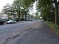
| + | Image:2021-10-15 52 4 FelixTheCat 1.JPG | The bit of Sint Martinuslaan where the hash was located. | ||
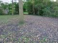
| + | Image:2021-10-15 52 4 FelixTheCat 2.JPG | The point is near the second tree, on the right side of the skip. | ||
| + | Image:2021-10-15 52 4 FelixTheCat 3.png | GPS proof. | ||
| + | Image:2021-10-15 52 4 FelixTheCat 4.JPG | Lloyd celebrating on my bike. | ||
| + | Image:2021-10-15 52 4 FelixTheCat 5.JPG | The hashtree. | ||
| + | Image:2021-10-15 52 4 FelixTheCat 6.JPG | The rest of the street, looking southeast. | ||
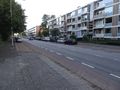
| + | Image:2021-10-15 52 4 FelixTheCat 7.JPG | The rest of the street, looking northwest. | ||
</gallery> | </gallery> | ||
== Achievements == | == Achievements == | ||
{{#vardefine:ribbonwidth|800px}} | {{#vardefine:ribbonwidth|800px}} | ||
| − | + | {{bicycle geohash | |
| − | + | | latitude = 52 | |
| − | + | | longitude = 4 | |
| − | + | | date = 2021-10-15 | |
| − | + | | name = [[User:FelixTheCat|FelixTheCat]] ([[User talk:FelixTheCat|talk]]) | |
| − | + | | distance = 8 km | |
| − | + | }} | |
| − | |||
| − | |||
| − | |||
| − | |||
| − | |||
| − | |||
| − | |||
| − | |||
| − | |||
[[Category:Expeditions]] | [[Category:Expeditions]] | ||
| − | |||
[[Category:Expeditions with photos]] | [[Category:Expeditions with photos]] | ||
| − | |||
| − | |||
| − | |||
| − | |||
| − | |||
[[Category:Coordinates reached]] | [[Category:Coordinates reached]] | ||
| − | + | {{location|NL|ZH}} | |
| − | |||
| − | |||
| − | |||
| − | |||
| − | |||
| − | |||
| − | |||
| − | |||
| − | |||
| − | |||
| − | |||
| − | |||
| − | |||
| − | |||
| − | |||
| − | |||
| − | |||
Latest revision as of 15:42, 19 October 2021
| Fri 15 Oct 2021 in 52,4: 52.0809080, 4.3679645 geohashing.info google osm bing/os kml crox |
Location
Sint Martinuslaan in Voorburg, South Holland province.
Participants
Expedition
Today's hash was in a residential area in Voorburg. The exact point was about 6 km as the crow flies from my workplace, so I decided to go there on my bike after work. Our last meeting of the week finished at about 17:10 and I set off soon after. The weather was fine and the ride was uneventful. I reached the point, which was in a kind of park next to some apartment buildings, took some photos and then got back on the road. I was quite familiar with the area, since it was pretty much on the route I rode to school. For old times' sake I re-visited that route, had a look at my old school (the building of which has been modernized almost to the point that it isn't recognizable anymore), then got lost and spent about ten minutes finding my way home again.
Photos
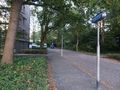
The bit of Sint Martinuslaan where the hash was located.
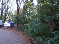
The point is near the second tree, on the right side of the skip.
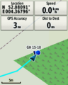
GPS proof.
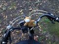
Lloyd celebrating on my bike.
The hashtree.
The rest of the street, looking southeast.
The rest of the street, looking northwest.


Achievements
FelixTheCat (talk) earned the Bicycle geohash achievement
|