Difference between revisions of "2021-10-16 40 -111"
From Geohashing
m (Location) |
(images) |
||
| Line 1: | Line 1: | ||
| − | + | [[Image:2021-10-16 40 -111 Spot.jpg|thumb|left]] | |
| − | [[Image: | ||
| − | |||
| − | |||
| − | |||
| − | |||
| − | |||
| − | |||
{{meetup graticule | {{meetup graticule | ||
| lat=40 | | lat=40 | ||
| Line 27: | Line 20: | ||
== Photos == | == Photos == | ||
| − | |||
| − | |||
| − | |||
<gallery perrow="5"> | <gallery perrow="5"> | ||
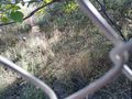
| + | Image:2021-10-16 40 -111 Spot.jpg | spot | ||
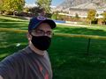
| + | Image:2021-10-16 40 -111 Grin view.jpg | view of the park from the spot with a grin | ||
| + | Image:2021-10-16 40 -111 Grin spot.jpg | grin towards the spot | ||
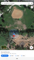
| + | Image:2021-10-16 40 -111 gps.png | the gps | ||
</gallery> | </gallery> | ||
Latest revision as of 15:24, 31 October 2021

| Sat 16 Oct 2021 in 40,-111: 40.4137404, -111.7530277 geohashing.info google osm bing/os kml crox |
Location
In an abandoned lot just south of Heiselt's Hollow Park in Cedar Hills.
Participants
Plans
Head up in the afternoon, and take the kids to a park. See if the coords are easily reachable.
Expedition
I headed to the park, but there was a fence in the way. The lot didn't look abandoned, as there was an RV trailer on it, so I decided not to go on it, but it was close enough to the fence so that I could be within GPS precision whilst staying in the park.
Photos
spot
view of the park from the spot with a grin

grin towards the spot
the gps


