Difference between revisions of "2021-10-18 47 -122"
From Geohashing
([live picture]Stupid grin [https://openstreetmap.org/?mlat=47.66242910&mlon=-122.20473790&zoom=16 @47.6624,-122.2047]) |
m (Location) |
||
| (3 intermediate revisions by 2 users not shown) | |||
| Line 15: | Line 15: | ||
== Location == | == Location == | ||
<!-- where you've surveyed the hash to be --> | <!-- where you've surveyed the hash to be --> | ||
| + | This Geohash is located on Lakeview Drive in Kirkland. | ||
== Participants == | == Participants == | ||
<!-- who attended: If you link to your wiki user name in this section, your expedition will be picked up by the various statistics generated for geohashing. You may use three tildes ~ as a shortcut to automatically insert the user signature of the account you are editing with. | <!-- who attended: If you link to your wiki user name in this section, your expedition will be picked up by the various statistics generated for geohashing. You may use three tildes ~ as a shortcut to automatically insert the user signature of the account you are editing with. | ||
--> | --> | ||
| − | + | *[[User:Zebburkeconte|Zebburkeconte]] | |
| − | + | *his dad | |
| − | |||
== Expedition == | == Expedition == | ||
<!-- how it all turned out. your narrative goes here. --> | <!-- how it all turned out. your narrative goes here. --> | ||
| − | + | *This was an easy one! I was surprised nobody already made it before us. Reached with my dad around 10:30pm. -- [[User:Zebburkeconte|Zebburkeconte]] ([[User talk:Zebburkeconte|talk]]) 22:30, 18 October 2021 (PDT) | |
| − | |||
== Photos == | == Photos == | ||
| Line 36: | Line 35: | ||
Image:2021-10-18_47_-122_Zebburkeconte_1634621202270.jpg|Stupid grin [https://openstreetmap.org/?mlat=47.66242910&mlon=-122.20473790&zoom=16 @47.6624,-122.2047] | Image:2021-10-18_47_-122_Zebburkeconte_1634621202270.jpg|Stupid grin [https://openstreetmap.org/?mlat=47.66242910&mlon=-122.20473790&zoom=16 @47.6624,-122.2047] | ||
| + | |||
| + | Image:2021-10-18_47_-122_Zebburkeconte_1634621355343.jpg|GPS acting up but we definitely got there [https://openstreetmap.org/?mlat=47.66246200&mlon=-122.20469310&zoom=16 @47.6625,-122.2047] | ||
</gallery> | </gallery> | ||
| Line 42: | Line 43: | ||
<!-- Add any achievement ribbons you earned below, or remove this section --> | <!-- Add any achievement ribbons you earned below, or remove this section --> | ||
| − | |||
| − | |||
| − | |||
| − | |||
| − | |||
| − | |||
| − | |||
| − | |||
| − | |||
| − | |||
| − | |||
| − | |||
| − | |||
| − | |||
[[Category:Expeditions]] | [[Category:Expeditions]] | ||
| − | |||
[[Category:Expeditions with photos]] | [[Category:Expeditions with photos]] | ||
| − | |||
| − | |||
| − | |||
| − | |||
| − | |||
[[Category:Coordinates reached]] | [[Category:Coordinates reached]] | ||
| − | + | {{location|US|WA|KN}} | |
| − | |||
| − | |||
| − | |||
| − | |||
| − | |||
| − | |||
| − | |||
| − | |||
| − | |||
| − | |||
| − | |||
| − | |||
| − | |||
| − | |||
| − | |||
| − | |||
| − | |||
Latest revision as of 18:42, 19 October 2021
| Mon 18 Oct 2021 in 47,-122: 47.6624428, -122.2047947 geohashing.info google osm bing/os kml crox |
Location
This Geohash is located on Lakeview Drive in Kirkland.
Participants
- Zebburkeconte
- his dad
Expedition
- This was an easy one! I was surprised nobody already made it before us. Reached with my dad around 10:30pm. -- Zebburkeconte (talk) 22:30, 18 October 2021 (PDT)
Photos
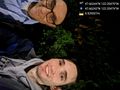
Stupid grin @47.6624,-122.2047
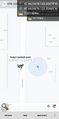
GPS acting up but we definitely got there @47.6625,-122.2047

