Difference between revisions of "2021-11-20 61 23"
From Geohashing
(An expedition message sent via Geohash Droid for Android.) |
m (Location) |
||
| (4 intermediate revisions by 2 users not shown) | |||
| Line 15: | Line 15: | ||
== Location == | == Location == | ||
<!-- where you've surveyed the hash to be --> | <!-- where you've surveyed the hash to be --> | ||
| + | This Geohash is located next to the road to Särkijärvi public beach. | ||
== Participants == | == Participants == | ||
<!-- who attended: If you link to your wiki user name in this section, your expedition will be picked up by the various statistics generated for geohashing. You may use three tildes ~ as a shortcut to automatically insert the user signature of the account you are editing with. | <!-- who attended: If you link to your wiki user name in this section, your expedition will be picked up by the various statistics generated for geohashing. You may use three tildes ~ as a shortcut to automatically insert the user signature of the account you are editing with. | ||
--> | --> | ||
| + | *[[User:Tmsurveys|Tmsurveys]] | ||
== Plans == | == Plans == | ||
| Line 26: | Line 28: | ||
<!-- how it all turned out. your narrative goes here. --> | <!-- how it all turned out. your narrative goes here. --> | ||
| + | |||
| + | *The hashpoint is less than 1 km from where I live, next to the road to Särkijärvi public beach. Going to check out the location and do a survey of the surrounding if feasible. -- [[User:Tmsurveys|Tmsurveys]] ([[User talk:Tmsurveys|talk]]) 13:22, 20 November 2021 (GMT+02:00) | ||
== Tracklog == | == Tracklog == | ||
<!-- if your GPS device keeps a log, you may use Template:Tracklog, post a link here, or both --> | <!-- if your GPS device keeps a log, you may use Template:Tracklog, post a link here, or both --> | ||
| Line 34: | Line 38: | ||
--> | --> | ||
<gallery perrow="5"> | <gallery perrow="5"> | ||
| + | |||
| + | Image:2021-11-20_61_23_tmsurveys_1637407894510.jpg|Reached the hashpoint. It's right next to the road. [https://openstreetmap.org/?mlat=61.45057060&mlon=23.82020020&zoom=16 @61.4506,23.8202] | ||
| + | |||
| + | Image:2021-11-20_61_23_tmsurveys_1637407967208.jpg|This tree stump is pretty close to the center of the hashpoint. [https://openstreetmap.org/?mlat=61.45058100&mlon=23.82020700&zoom=16 @61.4506,23.8202] | ||
</gallery> | </gallery> | ||
| Line 40: | Line 48: | ||
<!-- Add any achievement ribbons you earned below, or remove this section --> | <!-- Add any achievement ribbons you earned below, or remove this section --> | ||
| − | |||
| − | |||
| − | |||
| − | |||
| − | |||
| − | |||
| − | |||
| − | |||
| − | |||
| − | |||
| − | |||
| − | |||
| − | |||
| − | |||
[[Category:Expeditions]] | [[Category:Expeditions]] | ||
| − | |||
[[Category:Expeditions with photos]] | [[Category:Expeditions with photos]] | ||
| − | |||
| − | |||
| − | |||
| − | |||
| − | |||
[[Category:Coordinates reached]] | [[Category:Coordinates reached]] | ||
| − | + | {{location|FI|11}} | |
| − | |||
| − | |||
| − | |||
| − | |||
| − | |||
| − | |||
| − | |||
| − | |||
| − | |||
| − | |||
| − | |||
| − | |||
| − | |||
| − | |||
| − | |||
| − | |||
| − | |||
Latest revision as of 13:42, 23 November 2021
| Sat 20 Nov 2021 in 61,23: 61.4505570, 23.8201584 geohashing.info google osm bing/os kml crox |
Location
This Geohash is located next to the road to Särkijärvi public beach.
Participants
Plans
Expedition
- The hashpoint is less than 1 km from where I live, next to the road to Särkijärvi public beach. Going to check out the location and do a survey of the surrounding if feasible. -- Tmsurveys (talk) 13:22, 20 November 2021 (GMT+02:00)
Tracklog
Photos
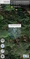
Reached the hashpoint. It's right next to the road. @61.4506,23.8202
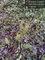
This tree stump is pretty close to the center of the hashpoint. @61.4506,23.8202

