Difference between revisions of "2021-12-17 62 29"
(Created page with "{{Subst:Expedition}}") |
|||
| (5 intermediate revisions by 2 users not shown) | |||
| Line 1: | Line 1: | ||
| − | + | {{meetup graticule | |
| − | |||
| − | |||
| − | |||
| − | |||
| − | |||
| − | |||
| − | |||
| − | |||
| lat={{#explode:{{SUBPAGENAME}}| |1}} | | lat={{#explode:{{SUBPAGENAME}}| |1}} | ||
| lon={{#explode:{{SUBPAGENAME}}| |2}} | | lon={{#explode:{{SUBPAGENAME}}| |2}} | ||
| date={{#explode:{{SUBPAGENAME}}| |0}} | | date={{#explode:{{SUBPAGENAME}}| |0}} | ||
| − | }} | + | }} |
__NOTOC__ | __NOTOC__ | ||
== Location == | == Location == | ||
| − | + | In a forest near Jukolankatu road in Joensuu. About 400 metres from my home. | |
== Participants == | == Participants == | ||
| − | + | * [[User:Kripakko|Kripakko]] | |
| − | |||
== Plans == | == Plans == | ||
| − | + | This point is very close to my home and on public property. Now I have good chances of scoring several achievements, perhaps on several expeditions: | |
| + | # Reconnaissance mission at midnight. As I write this, it is less than two hours to midnight. | ||
| + | # After about half past eight, there is enough daylight so I can see without artificial light. I can try to build a snowman and do other silly things if I feel like it. | ||
| + | # Sunrise at 9:28. Yes, I am not far from the arctic circle, and the winter solstice will occur in a few days. | ||
| + | |||
| + | We discussed a possible [[Frozen Geohash|Frozen]] [[Hobbit achievement]] on Discord. While it will be theoretically possible (the temperature will be about −5 °C), I am afraid of how my feet will cope. I could probably run to the hashpoint barefoot and back home, but stopping twice to eat might be too much to take. I will consider it in the morning. | ||
| + | |||
| + | == Expedition #1 == | ||
| + | I left for the first visit just before midnight. I got outside, and after a couple of minutes of jogging I was at the hashpoint. For some reason, I had a surprising amount of trouble finding it with the GPS receiver: the measured location jumped all over the place, and the GPS uncertainty was high, while it usually stabilises to 2–4 m. Regardless, I was able to get to a place where I could take photos for proof. | ||
| + | |||
| + | I will be back later today. I will need taller rubber boots since there was too much snow for my "winter boots", about 40 cm. The temperature was 0 °C, and it is expected to get down to −5 °C during the day. There was sufficient light from the street lights that I could see perfectly, but I will need to wait for the morning to get enough light for the camera. | ||
| + | |||
| + | == Expedition #2 == | ||
| + | I had more serious things to do, so I decided to just make a quick visit at sunrise. I ended up inadvertently delaying my departure from home and arrived at the hashpoint at exactly the sunrise time of 9:28, which I had determined using [https://xephem.github.io/XEphem/Site/xephem.html XEphem]. [https://www.suncalc.org/#/62.6176,29.8096,14/2021.12.17/10:28/1/3 Suncalc.org], [https://www.timeanddate.com/sun/finland/joensuu timeanddate.com] and [https://sunrisesunsetmap.com/ sunrisesunsetmap.com] give sunrise times 9:28, 9:29 and 9:29 respectively. My Garmin eTrex 30 shows 9:27, but I guess we can ignore that. | ||
| − | + | I took a video of my approach to the hashpoint. It turned out to be not very great, so I will not publish it for now. At the very least, it needs stabilisation, for which I do not have time now. I took two snapshots from it to show how the hashpoint looked like and that I was there at sunrise time. I also brought my thermometer which showed that the temperature was −1 °C, not as low as expected. | |
| − | |||
| − | + | There were criss-crossing tractor tracks in the forest, and I saw a worker working on the tractor a short distance away. Perhaps some forest maintenance work is done here currently. I did not want to draw his attention by doing anything peculiar, so I just took some photos and left. I could make snowballs with some difficulty, but I did not want to spend time building a snowman. | |
| − | + | ||
| + | I decided against trying to get the Frozen Hobbit achievement. It was cold, snowy and slippery. While I would have been physically able to do it, I would likely have gotten my feet frostbitten. I know what it feels like, and I definitely do not want to feel it again. | ||
== Photos == | == Photos == | ||
| − | < | + | <gallery perrow="4"> |
| − | Image: | + | Image:2021-12-17_62_29_01-gpsr1.jpg | GPS receiver at the hashpoint at midnight. The image is blurry, but is shows the location N 62.62078°, E 29.81023°, 3 m to the geohash, with a GPS uncertainty of 6 m. |
| − | -- | + | Image:2021-12-17_62_29_02-gpsr2.jpg | Legible proof of location. |
| − | + | Image:2021-12-17_62_29_03-gpsr3.jpg | Proof of date and time. | |
| + | Image:2021-12-17_62_29_04-selfie1.jpg | Selfie at the hashpoint at midnight. | ||
| + | Image:2021-12-17_62_29_05-hashpoint.jpg | Arriving at the hashpoint. A blurry snapshot from the video. | ||
| + | Image:2021-12-17_62_29_06-gpsr4.jpg | GPS receiver at the hashpoint at sunrise time. Another snapshot from the video. The location is N 62.62072°, E 29.81011°, which is 6.1 m from the geohash. Eh, close enough. | ||
| + | Image:2021-12-17_62_29_07-selfie2.jpg | Selfie at the hashpoint after sunrise. | ||
| + | Image:2021-12-17_62_29_08-thermometer.jpg | My thermometer showing that the temperature was −1 °C. | ||
</gallery> | </gallery> | ||
== Achievements == | == Achievements == | ||
{{#vardefine:ribbonwidth|800px}} | {{#vardefine:ribbonwidth|800px}} | ||
| − | |||
| − | + | {{land geohash | latitude = 62 | longitude = 29 | date = 2021-12-17 | name = Kripakko}} | |
| − | + | {{midnight geohash | latitude = 62 | longitude = 29 | date = 2021-12-17 | name = Kripakko}} | |
| − | + | {{walk geohash | latitude = 62 | longitude = 29 | date = 2021-12-17 | name = Kripakko}} | |
| + | {{sunrise geohash | latitude = 62 | longitude = 29 | date = 2021-12-17 | name = Kripakko}} | ||
| + | {{frozen geohash | latitude = 62 | longitude = 29 | date = 2021-12-17 | name = Kripakko | temperature = −1°C}} | ||
| + | {{couch potato geohash | latitude = 62 | longitude = 29 | date = 2021-12-17 | name = Kripakko | honor = true}} | ||
| − | |||
| − | |||
| − | |||
| − | |||
| − | |||
| − | |||
| − | |||
| − | |||
| − | |||
| − | |||
[[Category:Expeditions]] | [[Category:Expeditions]] | ||
| − | |||
[[Category:Expeditions with photos]] | [[Category:Expeditions with photos]] | ||
| − | |||
| − | |||
| − | |||
| − | |||
| − | |||
[[Category:Coordinates reached]] | [[Category:Coordinates reached]] | ||
| − | + | {{location|FI|13}} | |
| − | |||
| − | |||
| − | |||
| − | |||
| − | |||
| − | |||
| − | |||
| − | |||
| − | |||
| − | |||
| − | |||
| − | |||
| − | |||
| − | |||
| − | |||
| − | |||
| − | |||
Latest revision as of 08:49, 17 December 2021
| Fri 17 Dec 2021 in 62,29: 62.6207624, 29.8101840 geohashing.info google osm bing/os kml crox |
Location
In a forest near Jukolankatu road in Joensuu. About 400 metres from my home.
Participants
Plans
This point is very close to my home and on public property. Now I have good chances of scoring several achievements, perhaps on several expeditions:
- Reconnaissance mission at midnight. As I write this, it is less than two hours to midnight.
- After about half past eight, there is enough daylight so I can see without artificial light. I can try to build a snowman and do other silly things if I feel like it.
- Sunrise at 9:28. Yes, I am not far from the arctic circle, and the winter solstice will occur in a few days.
We discussed a possible Frozen Hobbit achievement on Discord. While it will be theoretically possible (the temperature will be about −5 °C), I am afraid of how my feet will cope. I could probably run to the hashpoint barefoot and back home, but stopping twice to eat might be too much to take. I will consider it in the morning.
Expedition #1
I left for the first visit just before midnight. I got outside, and after a couple of minutes of jogging I was at the hashpoint. For some reason, I had a surprising amount of trouble finding it with the GPS receiver: the measured location jumped all over the place, and the GPS uncertainty was high, while it usually stabilises to 2–4 m. Regardless, I was able to get to a place where I could take photos for proof.
I will be back later today. I will need taller rubber boots since there was too much snow for my "winter boots", about 40 cm. The temperature was 0 °C, and it is expected to get down to −5 °C during the day. There was sufficient light from the street lights that I could see perfectly, but I will need to wait for the morning to get enough light for the camera.
Expedition #2
I had more serious things to do, so I decided to just make a quick visit at sunrise. I ended up inadvertently delaying my departure from home and arrived at the hashpoint at exactly the sunrise time of 9:28, which I had determined using XEphem. Suncalc.org, timeanddate.com and sunrisesunsetmap.com give sunrise times 9:28, 9:29 and 9:29 respectively. My Garmin eTrex 30 shows 9:27, but I guess we can ignore that.
I took a video of my approach to the hashpoint. It turned out to be not very great, so I will not publish it for now. At the very least, it needs stabilisation, for which I do not have time now. I took two snapshots from it to show how the hashpoint looked like and that I was there at sunrise time. I also brought my thermometer which showed that the temperature was −1 °C, not as low as expected.
There were criss-crossing tractor tracks in the forest, and I saw a worker working on the tractor a short distance away. Perhaps some forest maintenance work is done here currently. I did not want to draw his attention by doing anything peculiar, so I just took some photos and left. I could make snowballs with some difficulty, but I did not want to spend time building a snowman.
I decided against trying to get the Frozen Hobbit achievement. It was cold, snowy and slippery. While I would have been physically able to do it, I would likely have gotten my feet frostbitten. I know what it feels like, and I definitely do not want to feel it again.
Photos
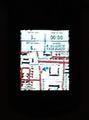
GPS receiver at the hashpoint at midnight. The image is blurry, but is shows the location N 62.62078°, E 29.81023°, 3 m to the geohash, with a GPS uncertainty of 6 m.
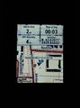
Legible proof of location.
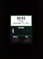
Proof of date and time.
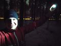
Selfie at the hashpoint at midnight.
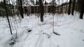
Arriving at the hashpoint. A blurry snapshot from the video.
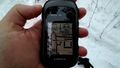
GPS receiver at the hashpoint at sunrise time. Another snapshot from the video. The location is N 62.62072°, E 29.81011°, which is 6.1 m from the geohash. Eh, close enough.
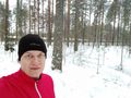
Selfie at the hashpoint after sunrise.
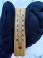
My thermometer showing that the temperature was −1 °C.


Achievements
Kripakko earned the Land geohash achievement
|
Kripakko earned the Midnight Geohash achievement
|
Kripakko earned the Walk geohash Achievement
|
Kripakko earned the Sunrise Geohash Achievement
|

