Difference between revisions of "2021-12-22 51 -2"
(Created page with "{{meetup graticule |lat=51 |lon=-2 |date=2021-12-22 }} __NOTOC__ == Location == East side of Syde; side of a Syde Farm field. == Participants == *DanQ == Plans...") |
|||
| Line 3: | Line 3: | ||
|lon=-2 | |lon=-2 | ||
|date=2021-12-22 | |date=2021-12-22 | ||
| − | }} | + | }} __NOTOC__ |
| − | __NOTOC__ | ||
== Location == | == Location == | ||
East side of Syde; side of a Syde Farm field. | East side of Syde; side of a Syde Farm field. | ||
== Participants == | == Participants == | ||
| − | *[[User:DanQ| | + | *[[User:DanQ|Dan Q]] |
== Plans == | == Plans == | ||
| Line 15: | Line 14: | ||
== Expedition == | == Expedition == | ||
| − | + | Given that I was driving half way from home to this hashpoint to run an errand ''anyway'', I figured I might as well push the battery on the EV a little further. Coming over the graticule line would, if successful, expand my [[Minesweeper Geohash|Minesweeper score]], and as it's such a beautiful frosty morning it seemed like great conditions for a bit of an explore. | |
| + | |||
| + | I'd hoped to drive most of the way to the hashpoint and only walk a short distance, but I soon discovered that the nearest road is signposted as being for access to Syde Farm only (and is narrow enough that passing a vehicle coming the other way would be extremely awkward), so I parked up near geocache [https://www.geocaching.com/geocache/GC1WXE1_a-road-anarchy-a417-stand-deliver GC1WXE1] and hiked along a frozen bridleway to get closer to the hashpoint. | ||
| + | |||
| + | Reached the hashpoint around 10:15, turned around, and headed back, [https://www.geocaching.com/seek/log.aspx?LUID=29b2ca20-b778-4dde-81ac-f69e649b88dd nabbing the geocache] on the way. By the time I reached the car my hands were freezing and it was only as I returned my GPSr to my coat pocket that I remembered that I'd been carrying my gloves all along. | ||
== Tracklog == | == Tracklog == | ||
| − | + | === Entire journey === | |
| + | {{ tracklog | Track_2021-12-22 51 -2.gpx }} | ||
| + | Download: [[:File:Track_2021-12-22 51 -2.gpx]] | ||
| + | |||
| + | === Walking part (after I remembered to start tracking it) === | ||
| + | {{ tracklog | activity_7994361945.gpx }} | ||
| + | Download: [[:File:activity_7994361945.gpx]] | ||
== Photos == | == Photos == | ||
| − | |||
| − | |||
| − | |||
<gallery perrow='5'> | <gallery perrow='5'> | ||
| + | Image:20211222_074253.jpg | Sunrise this morning | ||
| + | Image:20211222_094847.jpg | Syde Farm from a distance | ||
| + | Image:20211222_094912.jpg | I found a footpath! | ||
| + | Image:20211222_101008.jpg | Zero point | ||
| + | Image:20211222_101017.jpg | Silly grin (out standing in my field) | ||
| + | Image:20211222_101022.jpg | View from the hashpoint | ||
</gallery> | </gallery> | ||
== Achievements == | == Achievements == | ||
{{#vardefine:ribbonwidth|100%}} | {{#vardefine:ribbonwidth|100%}} | ||
| − | + | {{Minesweeper geohash | |
| − | + | | graticule = Swindon, United Kingdom | |
| − | + | | ranknumber = 5 | |
| − | + | | n = true | |
| − | + | | ne = true | |
| + | | e = true | ||
| + | | s = true | ||
| + | | w = true | ||
| + | | name = DanQ | ||
| + | }} | ||
| − | |||
| − | |||
| − | |||
| − | |||
| − | |||
| − | |||
| − | |||
| − | |||
| − | |||
| − | |||
[[Category:Expeditions]] | [[Category:Expeditions]] | ||
| − | |||
[[Category:Expeditions with photos]] | [[Category:Expeditions with photos]] | ||
| − | |||
| − | |||
| − | |||
| − | |||
| − | |||
[[Category:Coordinates reached]] | [[Category:Coordinates reached]] | ||
| − | |||
| − | |||
| − | |||
| − | |||
| − | |||
| − | |||
| − | |||
| − | |||
| − | |||
| − | |||
| − | |||
| − | |||
| − | |||
| − | |||
| − | |||
| − | |||
| − | |||
| − | |||
Revision as of 13:51, 22 December 2021
| Wed 22 Dec 2021 in 51,-2: 51.7967124, -2.0728107 geohashing.info google osm bing/os kml crox |
Location
East side of Syde; side of a Syde Farm field.
Participants
Plans
I'm going to be going half way here anyway on an errand. Might as well enjoy a morning hike and expand my Minesweeper grid, if I can.
Expedition
Given that I was driving half way from home to this hashpoint to run an errand anyway, I figured I might as well push the battery on the EV a little further. Coming over the graticule line would, if successful, expand my Minesweeper score, and as it's such a beautiful frosty morning it seemed like great conditions for a bit of an explore.
I'd hoped to drive most of the way to the hashpoint and only walk a short distance, but I soon discovered that the nearest road is signposted as being for access to Syde Farm only (and is narrow enough that passing a vehicle coming the other way would be extremely awkward), so I parked up near geocache GC1WXE1 and hiked along a frozen bridleway to get closer to the hashpoint.
Reached the hashpoint around 10:15, turned around, and headed back, nabbing the geocache on the way. By the time I reached the car my hands were freezing and it was only as I returned my GPSr to my coat pocket that I remembered that I'd been carrying my gloves all along.
Tracklog
Entire journey
Download: File:Track_2021-12-22 51 -2.gpx
Walking part (after I remembered to start tracking it)
Download: File:activity_7994361945.gpx
Photos

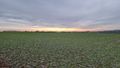
Sunrise this morning
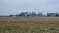
Syde Farm from a distance
I found a footpath!
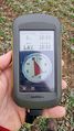
Zero point
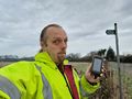
Silly grin (out standing in my field)
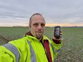
View from the hashpoint


Achievements
DanQ achieved level 5 of the Minesweeper Geohash achievement
|