Difference between revisions of "2021-12-29 48 10"
From Geohashing
m (Location correction) |
|||
| (2 intermediate revisions by one other user not shown) | |||
| Line 42: | Line 42: | ||
Image:2021-12-29_48_10_gnoerz_1640787886838.jpg|Parking exactly at the Landkreisgrenze. | Image:2021-12-29_48_10_gnoerz_1640787886838.jpg|Parking exactly at the Landkreisgrenze. | ||
Image:2021-12-29_48_10_gnoerz_1640788020975.jpg|Ground Zero in der Rückegasse [https://openstreetmap.org/?mlat=48.12492778&mlon=10.88673889&zoom=16 @48.1249,10.8867] | Image:2021-12-29_48_10_gnoerz_1640788020975.jpg|Ground Zero in der Rückegasse [https://openstreetmap.org/?mlat=48.12492778&mlon=10.88673889&zoom=16 @48.1249,10.8867] | ||
| + | |||
| + | Image:2021-12-29_48_10_gnoerz_1640788614696.jpg|HashTrap (empty) at the coordinates. | ||
| + | |||
| + | Image:2021-12-29_48_10_gnoerz_1640788729238.jpg|On my way through the forest: Does deer care about xkcd? [https://openstreetmap.org/?mlat=48.12736944&mlon=10.88371111&zoom=16 @48.1274,10.8837] | ||
</gallery> | </gallery> | ||
--> | --> | ||
| Line 60: | Line 64: | ||
[[Category:Expeditions with photos]] | [[Category:Expeditions with photos]] | ||
[[Category:Coordinates reached]] | [[Category:Coordinates reached]] | ||
| − | {{location|DE|BY| | + | {{location|DE|BY|LL}} |
Latest revision as of 04:52, 30 December 2021
| Wed 29 Dec 2021 in 48,10: 48.1249264, 10.8867442 geohashing.info google osm bing/os kml crox |
Location
In the "Westerholz" near Kaufering.
Participants
Plans
Expedition
It was years ago that i last visited the Westerholz - it was time to see it again. The Hash was located in the middle of the forest, which is one of the most interesting, manmade yet natural forests around. [1] for Details.
It was a 5km walk from the street, and i saw one biker and a women with pants down and her husband waiting on the walk.
Tracklog
Photos
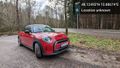
Parking exactly at the Landkreisgrenze.
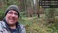
Ground Zero in der Rückegasse @48.1249,10.8867
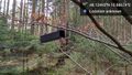
HashTrap (empty) at the coordinates.
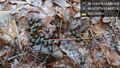
On my way through the forest: Does deer care about xkcd? @48.1274,10.8837


-->
Achievements
gnoerz earned the Land geohash achievement
|