Difference between revisions of "2022-01-01 51 4"
FelixTheCat (talk | contribs) (Created page with "{{subst:Expedition |lat = 51 |lon = 4 |date = 2022-01-01 }}") |
FelixTheCat (talk | contribs) m |
||
| (4 intermediate revisions by 2 users not shown) | |||
| Line 1: | Line 1: | ||
| − | + | {{meetup graticule | |
| − | |||
| − | |||
| − | |||
| − | |||
| − | |||
| − | |||
| − | |||
| − | |||
| lat=51 | | lat=51 | ||
| lon=4 | | lon=4 | ||
| date=2022-01-01 | | date=2022-01-01 | ||
| − | }} | + | }} |
__NOTOC__ | __NOTOC__ | ||
== Location == | == Location == | ||
| − | + | At the intersection of Voorhaven and Dwarshaven, Den Hoorn, municipality of Midden-Delfland, South Holland province. | |
== Participants == | == Participants == | ||
| − | + | * [[User:FelixTheCat|FelixTheCat]] ([[User talk:FelixTheCat|talk]]) | |
| − | + | * Kat the Awesome | |
| − | == | + | == Expedition == |
| − | + | Happy New Year everyone! I was happily surprised to see this hashpoint appear, on public land, about 2.5 km from my home. It even so happened that there was an almost dead straight path between the two, so I got ready to make this a Walk and Juggernaut geohash. Quite a nice surprise after spending December with no geohashes at all. The weather was nice; in fact we broke the record for warmest New Year's Day with temperatures in double digits. Kat and I left home, turned left and walked straight ahead for about 2 km, at which point we made a slight left turn to get closer to the straight-line path, but were foiled when we couldn't cross between two rows of houses where that appeared to be possible on the GPS map. We were forced to walk around the buildings on the right side, but kept as far left as possible to minimize our deviation from the straight line. Once we reached the hash we took a few pictures, and then walked back home again. | |
| − | + | After examining the GPS track log, we found a maximum deviation of 95 m from a straight line measuring 2.6 km. Therefore the deviation ratio is 1:27, qualifying us for the Juggernaut award! | |
| − | |||
== Tracklog == | == Tracklog == | ||
| − | + | {{tracklog | 2022-01-01_51_4_FelixTheCat.gpx}} | |
== Photos == | == Photos == | ||
| − | |||
| − | |||
| − | |||
<gallery perrow="5"> | <gallery perrow="5"> | ||
| + | Image:2022-01-01 51 4 FelixTheCat 1.JPG | Walking along Buitenwatersloot, right behind Delft Central Station. The hash is straight ahead. | ||
| + | Image:2022-01-01 51 4 FelixTheCat 2.JPG | Continuing along the same street. | ||
| + | Image:2022-01-01 51 4 FelixTheCat 3.JPG | And even further. We took a small path between the houses to get closer to the straight line. | ||
| + | Image:2022-01-01 51 4 FelixTheCat 6.JPG | We thought we could cross between those houses up ahead, but that turned out to be a cul-de-sac. We had to turn right and get back to the previous road. | ||
| + | Image:2022-01-01 51 4 FelixTheCat 4.JPG | A bit furter, along Drogerij, we could cross below this building. | ||
| + | Image:2022-01-01 51 4 FelixTheCat 5.JPG | We took this narrow path, again to keep as close to the straight line as possible. | ||
| + | Image:2022-01-01 51 4 FelixTheCat 7.JPG | We made it! The hash is on that little patch of grass. | ||
| + | Image:2022-01-01 51 4 FelixTheCat 8.png | GPS proof. | ||
| + | Image:2022-01-01 51 4 FelixTheCat 9.JPG | Lloyd and Toettoet celebrating. | ||
| + | Image:2022-01-01 51 4 FelixTheCat 10.JPG | A view of the hashgrass. | ||
| + | Image:2022-01-01 51 4 FelixTheCat 11.JPG | About 100 metres from the hash we met and patted this friendly cat. | ||
</gallery> | </gallery> | ||
== Achievements == | == Achievements == | ||
| + | {{Walk geohash | ||
| + | | latitude = 51 | ||
| + | | longitude = 4 | ||
| + | | date = 2022-01-01 | ||
| + | | name = [[User:FelixTheCat|FelixTheCat]] ([[User talk:FelixTheCat|talk]]) and Kat | ||
| + | | distance = 6 km | ||
| + | }} | ||
| + | {{Juggernaut achievement | ||
| + | | latitude = 51 | ||
| + | | longitude = 4 | ||
| + | | date = 2022-01-01 | ||
| + | | deviation = 27 | ||
| + | | name = [[User:FelixTheCat|FelixTheCat]] ([[User talk:FelixTheCat|talk]]) and Kat | ||
| + | }} | ||
{{#vardefine:ribbonwidth|800px}} | {{#vardefine:ribbonwidth|800px}} | ||
| − | + | {{Hashcat | |
| − | + | | latitude = 51 | |
| − | + | | longitude = 4 | |
| − | + | | date = 2022-01-01 | |
| − | [[ | + | | name = [[User:FelixTheCat|FelixTheCat]] ([[User talk:FelixTheCat|talk]]) and Kat |
| − | + | | image = 2022-01-01 51 4 FelixTheCat 11.JPG | |
| − | + | }} | |
| − | |||
| − | |||
| − | |||
| − | [[ | ||
| − | -- | ||
| − | |||
| − | |||
| − | |||
| − | |||
[[Category:Expeditions]] | [[Category:Expeditions]] | ||
| − | |||
[[Category:Expeditions with photos]] | [[Category:Expeditions with photos]] | ||
| − | |||
| − | |||
| − | |||
| − | |||
| − | |||
[[Category:Coordinates reached]] | [[Category:Coordinates reached]] | ||
| − | + | {{location|NL|ZH}} | |
| − | |||
| − | |||
| − | |||
| − | |||
| − | |||
| − | |||
| − | |||
| − | |||
| − | |||
| − | |||
| − | |||
| − | |||
| − | |||
| − | |||
| − | |||
| − | |||
| − | |||
Latest revision as of 09:48, 2 January 2022
| Sat 1 Jan 2022 in 51,4: 51.9990349, 4.3340696 geohashing.info google osm bing/os kml crox |
Location
At the intersection of Voorhaven and Dwarshaven, Den Hoorn, municipality of Midden-Delfland, South Holland province.
Participants
- FelixTheCat (talk)
- Kat the Awesome
Expedition
Happy New Year everyone! I was happily surprised to see this hashpoint appear, on public land, about 2.5 km from my home. It even so happened that there was an almost dead straight path between the two, so I got ready to make this a Walk and Juggernaut geohash. Quite a nice surprise after spending December with no geohashes at all. The weather was nice; in fact we broke the record for warmest New Year's Day with temperatures in double digits. Kat and I left home, turned left and walked straight ahead for about 2 km, at which point we made a slight left turn to get closer to the straight-line path, but were foiled when we couldn't cross between two rows of houses where that appeared to be possible on the GPS map. We were forced to walk around the buildings on the right side, but kept as far left as possible to minimize our deviation from the straight line. Once we reached the hash we took a few pictures, and then walked back home again.
After examining the GPS track log, we found a maximum deviation of 95 m from a straight line measuring 2.6 km. Therefore the deviation ratio is 1:27, qualifying us for the Juggernaut award!
Tracklog
Photos
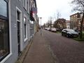
Walking along Buitenwatersloot, right behind Delft Central Station. The hash is straight ahead.
Continuing along the same street.
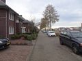
And even further. We took a small path between the houses to get closer to the straight line.
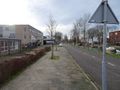
We thought we could cross between those houses up ahead, but that turned out to be a cul-de-sac. We had to turn right and get back to the previous road.
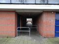
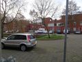
A bit furter, along Drogerij, we could cross below this building.
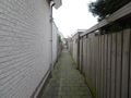
We took this narrow path, again to keep as close to the straight line as possible.
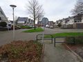
We made it! The hash is on that little patch of grass.
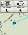
GPS proof.
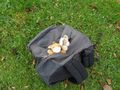
Lloyd and Toettoet celebrating.
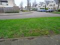
A view of the hashgrass.
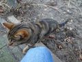
About 100 metres from the hash we met and patted this friendly cat.


Achievements
FelixTheCat (talk) and Kat earned the Walk geohash Achievement
|
FelixTheCat (talk) and Kat earned the Juggernaut achievement
|
FelixTheCat (talk) and Kat earned the Hashcat achievement
|