Difference between revisions of "2022-01-02 49 8"
From Geohashing
(New report) |
m (Location) |
||
| (3 intermediate revisions by one other user not shown) | |||
| Line 1: | Line 1: | ||
| − | + | {{meetup graticule | |
| − | |||
| − | |||
| − | |||
| − | |||
| − | |||
| − | |||
| − | |||
| − | |||
| lat=49 | | lat=49 | ||
| − | | lon= | + | | lon=8 |
| date=2022-01-02 | | date=2022-01-02 | ||
| − | }} | + | }} |
__NOTOC__ | __NOTOC__ | ||
| + | |||
== Location == | == Location == | ||
| − | + | ||
| + | In my childhood neighbourhood in Steinweiler. | ||
== Participants == | == Participants == | ||
| − | + | ||
| − | + | * [[User:DLichti|DLichti]] | |
== Plans == | == Plans == | ||
| − | + | ||
| + | There was no plan. | ||
== Expedition == | == Expedition == | ||
| − | |||
| − | + | This was an easy one. | |
| − | + | I noticed that todays hash point was a mere 900m from my (parents') place. | |
| + | So, I decided to take a short walk in the afternoon to do some OSM mapping and visit the location. | ||
| + | |||
| + | It was getting dark when I got there. | ||
| + | The location was on a short dead end between two gardens and the fields. | ||
| + | I took some pictures, recorded a proof, and went home again. | ||
== Photos == | == Photos == | ||
| − | + | ||
| − | |||
| − | |||
<gallery perrow="5"> | <gallery perrow="5"> | ||
| + | Image:2022-01-02 49 8 street.jpeg | Some christmas decorations in the street | ||
| + | Image:2022-01-02 49 8 fields.jpeg | Street lights of nearby towns in the sky | ||
| + | Image:2022-01-02 49 8 proof.png | proof | ||
| + | Image:2022-01-02 49 8 hat.jpeg | The hat was there. | ||
</gallery> | </gallery> | ||
| − | |||
| − | |||
| − | |||
| − | |||
| − | |||
| − | |||
| − | |||
| − | |||
| − | |||
| − | |||
| − | |||
| − | |||
| − | |||
| − | |||
| − | |||
| − | |||
| − | |||
| − | |||
[[Category:Expeditions]] | [[Category:Expeditions]] | ||
| − | + | [[Category:Coordinates reached]] | |
[[Category:Expeditions with photos]] | [[Category:Expeditions with photos]] | ||
| − | + | {{location|DE|RP|GER}} | |
| − | |||
| − | |||
| − | |||
| − | |||
| − | |||
| − | |||
| − | |||
| − | |||
| − | |||
| − | |||
| − | |||
| − | |||
| − | |||
| − | |||
| − | |||
| − | |||
| − | |||
| − | |||
| − | |||
| − | |||
| − | |||
| − | |||
| − | |||
Latest revision as of 17:42, 2 January 2022
| Sun 2 Jan 2022 in 49,8: 49.1186794, 8.1456915 geohashing.info google osm bing/os kml crox |
Location
In my childhood neighbourhood in Steinweiler.
Participants
Plans
There was no plan.
Expedition
This was an easy one. I noticed that todays hash point was a mere 900m from my (parents') place. So, I decided to take a short walk in the afternoon to do some OSM mapping and visit the location.
It was getting dark when I got there. The location was on a short dead end between two gardens and the fields. I took some pictures, recorded a proof, and went home again.
Photos
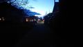
Some christmas decorations in the street
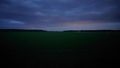
Street lights of nearby towns in the sky
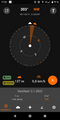
proof
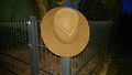
The hat was there.


