Difference between revisions of "2022-01-06 31 121"
(Created page with "{{meetup graticule |lat = 31 |lon = 121 |date = 2022-01-06 }} == Location == Yanggaozhong Road, in the urban area of Shanghai. Note that due to the GPS drift in China,...") |
|||
| Line 16: | Line 16: | ||
== Expedition == | == Expedition == | ||
| − | I left work at 5:30pm, and I took the metro as shown below | + | I left work at 5:30pm, and I took the metro as shown below in the image below. |
| − | + | <gallery perrow="2"> | |
| − | + | Image:Metro path to hashpoint 2022-01-06 31 121.jpg | Follow the black line | |
| − | + | Image:Metro_station_destination_2022-01-06_31_121.jpg | The destination station | |
| − | + | </gallery> | |
| − | + | I left the station at gate 3 of that station, and I saw the most stupid arrangement for metro station entries. | |
| − | + | <gallery perrow="1"> | |
| − | + | Image:Worst_engineering_design_I_have_ever_seen_2022-01-06_31_121.jpg | because someone decided to put two entries at the same location, right in front of each other. | |
| − | + | </gallery> | |
| − | + | Then I took a little walk guided by my phone. I got almost there... | |
| − | + | <gallery perrow="1"> | |
| − | + | Image:Almost there 2022-01-06 31 121.jpg | I have no idea why the GPS location is so inaccurate. | |
| − | + | </gallery> | |
| − | + | Then the accuracy of the GPS suddenly increased to about 5 meters. I had to keep walking. After a few minutes of walking and staring at my phone, waiting for the GPS location to update, I finally reached the hashpoint! | |
| − | + | <gallery perrow="3"> | |
| − | + | Image:Proof_2022-01-06_31_121.jpg | Proof | |
| − | + | Image:Hashpoint 2022-01-06 31 121.jpg | A photo taken at the hashpoint. | |
| − | + | Image:Me 2022-01-06 31 121.jpg | My first geohash. Yah! | |
| − | |||
| − | |||
| − | |||
| − | |||
| − | |||
| − | = | ||
| − | |||
| − | |||
| − | |||
| − | < | ||
| − | |||
| − | |||
| − | |||
| − | |||
| − | = | ||
| − | |||
| − | Image: | ||
| − | -- | ||
| − | |||
</gallery> | </gallery> | ||
== Achievements == | == Achievements == | ||
{{#vardefine:ribbonwidth|800px}} | {{#vardefine:ribbonwidth|800px}} | ||
| − | + | {{land geohash | |
| + | | latitude = 31 | ||
| + | | longitude = 121 | ||
| + | | date = 2022-01-06 | ||
| + | | name = LZ | ||
| + | | image = Hashpoint 2022-01-06 31 121.jpg | ||
| + | }} | ||
| − | + | [[Category:Coordinates reached]] | |
| − | |||
| − | [[Category: | ||
| − | |||
| − | |||
| − | |||
| − | |||
| − | |||
| − | |||
| − | |||
| − | |||
| − | |||
| − | |||
| − | |||
| − | |||
| − | |||
[[Category:Expeditions with photos]] | [[Category:Expeditions with photos]] | ||
| − | |||
| − | |||
| − | |||
| − | |||
| − | |||
[[Category:Coordinates reached]] | [[Category:Coordinates reached]] | ||
| − | |||
| − | |||
| − | |||
| − | |||
| − | |||
| − | |||
| − | |||
| − | |||
| − | |||
| − | |||
| − | |||
| − | |||
| − | |||
| − | |||
| − | |||
| − | |||
| − | |||
| − | |||
Revision as of 14:44, 6 January 2022
| Thu 6 Jan 2022 in 31,121: 31.2303124, 121.5469195 geohashing.info google osm bing/os kml crox |
Location
Yanggaozhong Road, in the urban area of Shanghai. Note that due to the GPS drift in China, the coordinate on many maps (such as Google Maps) does not agree with the true coordinate measured by a GPS device. The offset is around 100 meters (I think).
Participants
Plans
Well, I went to work (just during the school holiday) in the morning, and I checked the hash location. Wow today's location is actually a very nice one. It is in the urban area so it can reached by metros and buses. I checked the detail, it only required me to take the metro for around an hour and a little 5-minute walk from the station.
Expedition
I left work at 5:30pm, and I took the metro as shown below in the image below.
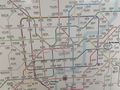
Follow the black line

The destination station


I left the station at gate 3 of that station, and I saw the most stupid arrangement for metro station entries.

because someone decided to put two entries at the same location, right in front of each other.

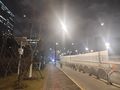
Then I took a little walk guided by my phone. I got almost there...
I have no idea why the GPS location is so inaccurate.

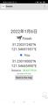
Then the accuracy of the GPS suddenly increased to about 5 meters. I had to keep walking. After a few minutes of walking and staring at my phone, waiting for the GPS location to update, I finally reached the hashpoint!

Proof
A photo taken at the hashpoint.

My first geohash. Yah!


Achievements
LZ earned the Land geohash achievement
|