Difference between revisions of "2022-01-06 40 -3"
(Created page with "<!-- [[Image:{{{image|IMAGE}}}|thumb|left]] --> <!-- Remove this section if you don't want an image at the top (left) of your report. You should remove the "Image...") |
(→Expedition) |
||
| (4 intermediate revisions by 2 users not shown) | |||
| Line 62: | Line 62: | ||
little traffic, the usually busy four lane roads were | little traffic, the usually busy four lane roads were | ||
somewhat deserted. So, set the cruise control at | somewhat deserted. So, set the cruise control at | ||
| − | 110 km/h and let the | + | 110 km/h and let the Wing fly. |
Such laid back highway cruising is really the domain of | Such laid back highway cruising is really the domain of | ||
| Line 75: | Line 75: | ||
called this a recreation area, | called this a recreation area, | ||
but it was a nice expedition anyway. | but it was a nice expedition anyway. | ||
| + | |||
| + | [[User:GeorgDerReisende|GeorgDerReisende]] ([[User talk:GeorgDerReisende|talk]]) found some comprehensive information about the bridge: | ||
| + | : https://route-1963.blogspot.com/2018/11/el-puente-viejo-de-san-martin-de-la-vega.html | ||
== Tracklog == | == Tracklog == | ||
| Line 86: | Line 89: | ||
Image:2022-01-06_40_-3_L1040869.JPG | View from the geohash towards the abandoned bridge. | Image:2022-01-06_40_-3_L1040869.JPG | View from the geohash towards the abandoned bridge. | ||
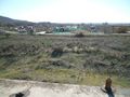
Image:2022-01-06_40_-3_L1040870.JPG | There is also an allotment garden colony, and I assume that the “No passage” refers to its actual area, but not to the way past it. | Image:2022-01-06_40_-3_L1040870.JPG | There is also an allotment garden colony, and I assume that the “No passage” refers to its actual area, but not to the way past it. | ||
| − | Image:2022-01-06_40_-3_L1040872.JPG | | + | Image:2022-01-06_40_-3_L1040872.JPG | Not sure if this would be my idea of a nice picnic spot. |
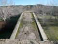
Image:2022-01-06_40_-3_L1040874.JPG | View of the allotment garden colony from the top of the bridge. | Image:2022-01-06_40_-3_L1040874.JPG | View of the allotment garden colony from the top of the bridge. | ||
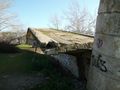
Image:2022-01-06_40_-3_L1040875.JPG | Collapsed… | Image:2022-01-06_40_-3_L1040875.JPG | Collapsed… | ||
| Line 102: | Line 105: | ||
[[Category:Expeditions]] | [[Category:Expeditions]] | ||
| − | + | ||
<!-- ==REQUEST FOR TWITTER BOT== Please leave either the New | <!-- ==REQUEST FOR TWITTER BOT== Please leave either the New | ||
report or the Expedition planning category in as long | report or the Expedition planning category in as long | ||
| Line 117: | Line 120: | ||
[[Category:Easy geohash]] | [[Category:Easy geohash]] | ||
| + | {{location|ES|MD}} | ||
Latest revision as of 15:29, 7 January 2022
| Thu 6 Jan 2022 in 40,-3: 40.2303124, -3.5469195 geohashing.info google osm bing/os kml crox |
Location
Near the remains of an abandoned bridge close to San Martín de la Vega.
Participants
Plans
Expedition
The geohash appeared to be easily accessible by the side of the road. First, looking on large scale on the Maps, I was hoping for another opportunity for a Speed racer achievement, like in expedition 2021-11-20_40_-3, but it was actually off the road.
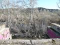
The location looked particularly interesting because it was close to the remains of an abandoned bride. The bridge was marked as a recreation area on the Maps, but the Street View indicated signs prohibiting to go there. So, I wanted to explore this.
The geohash was southeast of Madrid, so almost on the opposite side of my home base. Making use of the ring highway M-50, it were 74 km of mostly straight four lane roads, not very tempting from the motorcycling point of view. However, it turned out to be a bit special on that day.
It was on “Holy Three Kings”, and this is a very important holiday in Spain. Children get there gifts that day and not on Christmas. While on almost all public holidays most supermarkets are open, on “Holy Three Kings” really everything is closed. Thus, there was very little traffic, the usually busy four lane roads were somewhat deserted. So, set the cruise control at 110 km/h and let the Wing fly.
Such laid back highway cruising is really the domain of the Goldwing. It was so little traffic that I rode almost completely under cruise control, with only a few short interruptions when changing from one highway to the other.
The geohash turned out to be indeed easy to reach and the bridge offered opportunities to take photos. Though, not sure if I would have called this a recreation area, but it was a nice expedition anyway.
GeorgDerReisende (talk) found some comprehensive information about the bridge:
Tracklog
Photos
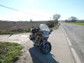
The geohash is 60 meters behind the Goldwing on the field, 20 meters from the road.
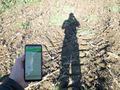
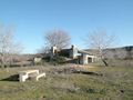
Here we are, after a short walk.
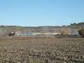
View from the geohash towards the abandoned bridge.
There is also an allotment garden colony, and I assume that the “No passage” refers to its actual area, but not to the way past it.
Not sure if this would be my idea of a nice picnic spot.
View of the allotment garden colony from the top of the bridge.
Collapsed…
…
Barely visible behind the trees, the river Jarama that this bridge once crossed.
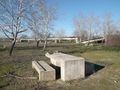
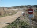
Recreation area 🤔


