Difference between revisions of "2022-01-15 39 -77"
From Geohashing
([live picture]Going to give this one a try, but on the way I saw this serious car accident [https://openstreetmap.org/?lat=39.09508860&lon=-77.15364780&zoom=16&layers=B000FTF @39.0951,-77.1536]) |
m (Location) |
||
| (5 intermediate revisions by 2 users not shown) | |||
| Line 15: | Line 15: | ||
== Location == | == Location == | ||
<!-- where you've surveyed the hash to be --> | <!-- where you've surveyed the hash to be --> | ||
| + | This Geohash is located in a forest near Haviland Hills. | ||
== Participants == | == Participants == | ||
<!-- who attended: If you link to your wiki user name in this section, your expedition will be picked up by the various statistics generated for geohashing. You may use three tildes ~ as a shortcut to automatically insert the user signature of the account you are editing with. | <!-- who attended: If you link to your wiki user name in this section, your expedition will be picked up by the various statistics generated for geohashing. You may use three tildes ~ as a shortcut to automatically insert the user signature of the account you are editing with. | ||
--> | --> | ||
| − | + | *[[User:OfficeLinebacker|OfficeLinebacker]] | |
| − | |||
| − | |||
== Expedition == | == Expedition == | ||
<!-- how it all turned out. your narrative goes here. --> | <!-- how it all turned out. your narrative goes here. --> | ||
| − | |||
| − | |||
| − | |||
== Photos == | == Photos == | ||
| Line 36: | Line 32: | ||
Image:2022-01-15_39_-77_OfficeLinebacker_1642271775713.jpg|Going to give this one a try, but on the way I saw this serious car accident [https://openstreetmap.org/?lat=39.09508860&lon=-77.15364780&zoom=16&layers=B000FTF @39.0951,-77.1536] | Image:2022-01-15_39_-77_OfficeLinebacker_1642271775713.jpg|Going to give this one a try, but on the way I saw this serious car accident [https://openstreetmap.org/?lat=39.09508860&lon=-77.15364780&zoom=16&layers=B000FTF @39.0951,-77.1536] | ||
| + | |||
| + | Image:2022-01-15_39_-77_OfficeLinebacker_1642273653563.jpg|Beautiful view about a mile and a half away [https://openstreetmap.org/?lat=39.17125980&lon=-77.01008260&zoom=16&layers=B000FTF @39.1713,-77.0101] | ||
| + | |||
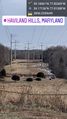
| + | Image:2022-01-15_39_-77_OfficeLinebacker_1642274387355.jpg|This is as close as we will get, I'm afraid. [https://openstreetmap.org/?lat=39.17879410&lon=-76.99997840&zoom=16&layers=B000FTF @39.1788,-77.0000] | ||
| + | |||
| + | Image:2022-01-15_39_-77_OfficeLinebacker_1642274469493.jpg|Got a picture of a cool Frozen waterfall. It's very cold today. [https://openstreetmap.org/?lat=39.17879040&lon=-76.99999640&zoom=16&layers=B000FTF @39.1788,-77.0000] | ||
| + | |||
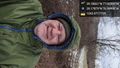
| + | Image:2022-01-15_39_-77_OfficeLinebacker_1642275473272.jpg|This simply cannot pass unnoted and recorded [https://openstreetmap.org/?lat=39.19325150&lon=-76.97570040&zoom=16&layers=B000FTF @39.1933,-76.9757] | ||
</gallery> | </gallery> | ||
| Line 42: | Line 46: | ||
<!-- Add any achievement ribbons you earned below, or remove this section --> | <!-- Add any achievement ribbons you earned below, or remove this section --> | ||
| − | |||
| − | |||
| − | |||
| − | |||
| − | |||
| − | |||
| − | |||
| − | |||
| − | |||
| − | |||
| − | |||
| − | |||
| − | |||
[[Category:Expeditions]] | [[Category:Expeditions]] | ||
| − | |||
[[Category:Expeditions with photos]] | [[Category:Expeditions with photos]] | ||
| − | |||
| − | |||
| − | |||
| − | |||
| − | |||
| − | |||
| − | |||
| − | |||
| − | |||
[[Category:Coordinates not reached]] | [[Category:Coordinates not reached]] | ||
| − | |||
| − | |||
[[Category:Not reached - Mother Nature]] | [[Category:Not reached - Mother Nature]] | ||
| − | + | {{location|US|MD|HO}} | |
| − | |||
| − | |||
| − | |||
| − | |||
| − | |||
| − | |||
| − | |||
| − | |||
| − | |||
| − | |||
Latest revision as of 09:44, 28 January 2022
| Sat 15 Jan 2022 in 39,-77: 39.1806112, -77.0036901 geohashing.info google osm bing/os kml crox |
Location
This Geohash is located in a forest near Haviland Hills.
Participants
Expedition
Photos
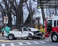
Going to give this one a try, but on the way I saw this serious car accident @39.0951,-77.1536
Beautiful view about a mile and a half away @39.1713,-77.0101
This is as close as we will get, I'm afraid. @39.1788,-77.0000
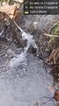
Got a picture of a cool Frozen waterfall. It's very cold today. @39.1788,-77.0000
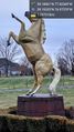
This simply cannot pass unnoted and recorded @39.1933,-76.9757


